
Understanding California’s Seismic Activity
California is renowned for its stunning coastlines, vibrant cities, and diverse landscapes, but it is also a region where the earth beneath our feet is in constant motion. As part of the Pacific Ring of Fire, a horseshoe-shaped zone of intense seismic activity, the state experiences thousands of earthquakes each year, ranging from imperceptible tremors to significant seismic events. For travelers and residents alike, understanding where these earthquakes occur and what drives them is crucial for safety and preparedness.
The most prominent geological feature responsible for California’s seismic drama is the San Andreas Fault. This massive transform fault runs for nearly 800 miles through the state, marking the boundary between the Pacific Plate and the North American Plate. As these tectonic plates grind past each other, immense stress builds up, which is periodically released in the form of earthquakes.
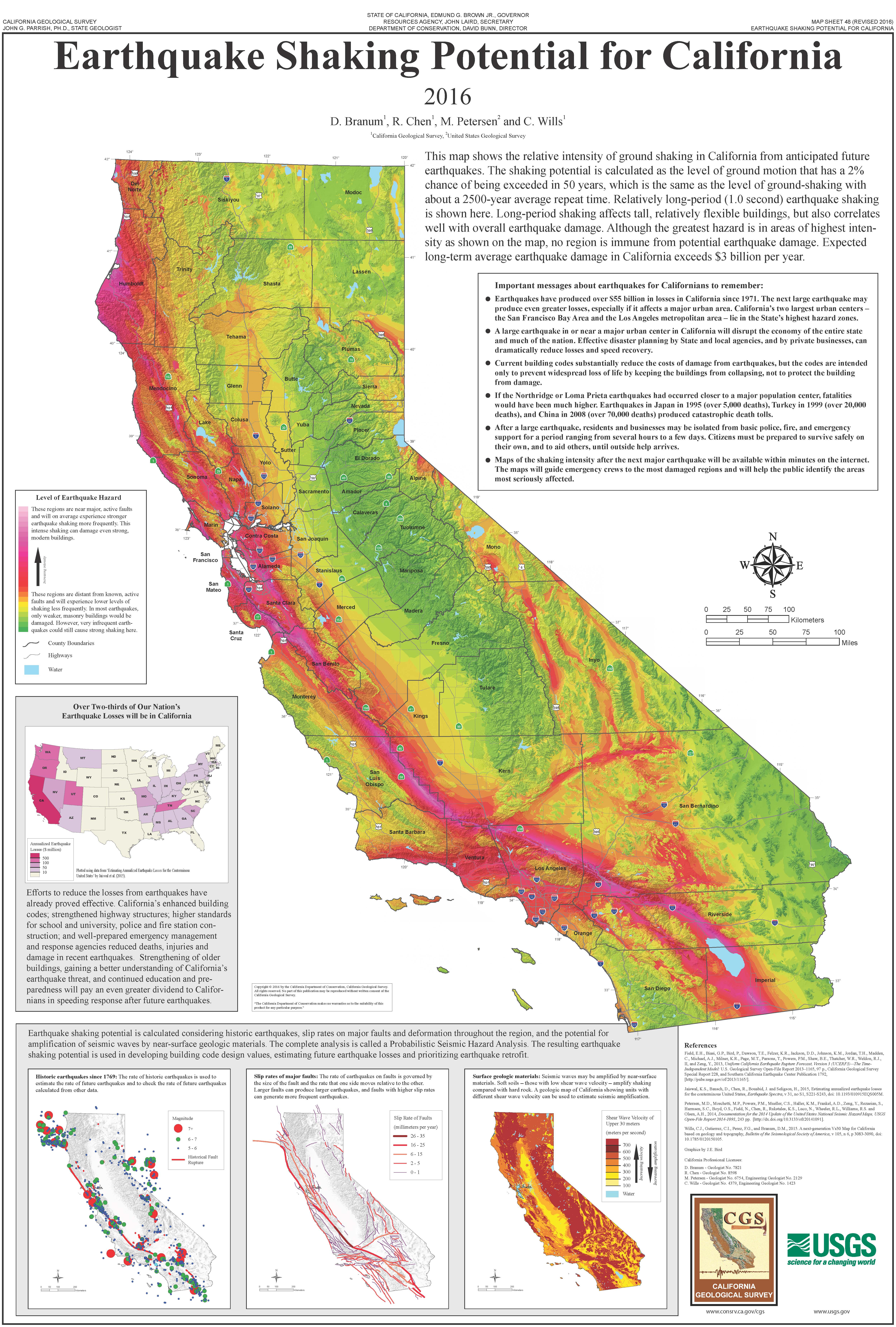
While the San Andreas Fault is the most famous, it’s far from the only source of seismic activity in California. Numerous smaller fault systems, often branching off the main fault or existing independently, crisscross the state. These include the Hayward Fault in the Bay Area, the Garlock Fault in Southern California, and the Owens Valley Fault near the Sierra Nevada. Each of these faults has the potential to generate earthquakes, influencing different regions of the state.
The distribution of seismic activity is not uniform. Historically, major earthquakes have occurred in various parts of California. The 1906 San Francisco earthquake devastated the city and surrounding areas. The 1989 Loma Prieta earthquake, a magnitude 6.9 event, significantly impacted the San Francisco Bay Area. In Southern California, the 1994 Northridge earthquake caused widespread damage in the Los Angeles metropolitan area, and the 1952 Kern County earthquake was one of the largest in Southern California’s recorded history. Recent significant events, like the 2019 Ridgecrest earthquakes, have highlighted the ongoing seismic potential in the Mojave Desert region.
The San Andreas Fault System
The San Andreas Fault is the principal fault system in California, a complex network of fractures in the Earth’s crust. It is a classic example of a strike-slip fault, meaning that the Earth’s blocks on either side of the fault move horizontally past each other. This movement is not smooth; the plates often get stuck, accumulating immense strain energy. When this strain exceeds the rock’s strength, a sudden slip occurs, releasing the energy as seismic waves, which we feel as an earthquake.
The fault can be broadly divided into three segments, each with a different seismic behavior:
- Northern Segment: This section runs from near Cape Mendocino south to Parkfield in San Luis Obispo County. It has been the source of major historical earthquakes, including the 1906 event. This segment is characterized by a high degree of locking, meaning significant stress accumulates here, posing a risk for a large future earthquake.
- Central Segment: From Parkfield to the Carrizo Plain, this segment exhibits more creep, a slow, continuous movement that releases stress gradually. While less prone to very large earthquakes, it can still produce moderate events. The town of Parkfield is famously studied for its earthquake behavior.
- Southern Segment: Extending from the Carrizo Plain southeast through the San Bernardino Mountains and into the desert regions, this segment has not experienced a major rupture in over 300 years. Geologists believe this “seismic gap” is storing a significant amount of energy, making it a prime candidate for a future large earthquake. This segment has produced significant earthquakes in the past, but the lack of a recent major rupture raises particular concern.
Other Significant Fault Zones
Beyond the San Andreas, California is laced with a multitude of other fault zones, each contributing to the state’s complex seismic landscape. Understanding these secondary systems is crucial as they can cause significant localized damage and contribute to the overall seismic hazard.

- Hayward Fault Zone: Located in the densely populated San Francisco Bay Area, the Hayward Fault is considered one of the most dangerous faults in the region. It runs directly through communities like Oakland, Berkeley, and Hayward. It is known for its significant creep, but also carries the potential for a magnitude 6.7 or larger earthquake, which could have devastating consequences due to the proximity of major urban centers.
- Owens Valley Fault System: This system, located east of the Sierra Nevada mountain range, was responsible for the destructive 1872 Owens Valley earthquake, one of the largest earthquakes ever recorded in California. It is a normal fault system, distinct from the strike-slip motion of the San Andreas, and has the potential to generate significant seismic events.
- Garlock Fault: This major thrust fault extends for over 150 miles east-west across Southern California, north of the San Andreas Fault, and runs through the Mojave Desert. While it hasn’t produced a major earthquake in historical times, studies suggest it is capable of generating large seismic events.
- Newport-Inglewood Fault Zone: This fault runs along the coast of Los Angeles County and Orange County, passing through densely populated coastal cities like Santa Monica, Long Beach, and Huntington Beach. It is capable of producing moderate to strong earthquakes that could cause significant damage to coastal infrastructure and communities.
Factors Influencing Earthquake Location and Intensity
The location and intensity of an earthquake are determined by a complex interplay of geological factors. When discussing where an earthquake might hit in California, several key elements come into play:
- Proximity to Plate Boundaries: Earthquakes are most common and tend to be strongest near the boundaries of tectonic plates. The San Andreas Fault system, being the primary boundary between the Pacific Plate and the North American Plate, is therefore the locus of much of California’s seismic activity. Areas immediately adjacent to this fault system are at the highest risk for experiencing the direct effects of a rupture.
- Fault Type and Behavior: Different types of faults generate earthquakes differently. Strike-slip faults, like the San Andreas, produce horizontal shaking. Normal faults, common in areas like the Owens Valley, involve one block of crust dropping relative to another, creating vertical displacement. Reverse faults, including thrust faults like the Garlock Fault, involve one block being pushed up and over another, capable of significant ground deformation. The specific behavior of a fault – whether it creeps slowly or locks up – also dictates its earthquake potential and the likelihood of large events.
- Depth of the Earthquake: The depth at which an earthquake originates, known as its hypocenter or focus, significantly influences the intensity of shaking felt at the surface. Shallow earthquakes (those occurring within a few miles of the surface) generally produce more intense shaking and damage than deeper ones, even if their magnitude is the same.
- Local Geology and Soil Conditions: The type of rock and soil beneath a particular area can amplify or attenuate seismic waves. Soft, unconsolidated sediments, such as those found in many California valleys and coastal plains, can significantly amplify shaking during an earthquake, leading to greater damage. Hard bedrock, on the other hand, tends to transmit seismic waves more efficiently, resulting in less amplification. This is why, for example, the shaking in cities built on landfill, like parts of the Bay Area, can be more severe than in areas with solid rock foundations, even if the earthquake’s epicenter is the same distance away.
- Magnitude of the Earthquake: The magnitude of an earthquake, a measure of the energy released, is the primary determinant of its potential for widespread impact. Larger magnitude earthquakes release more energy, travel further, and cause more significant ground motion. For instance, a magnitude 7.0 earthquake will have a far greater impact than a magnitude 4.0 earthquake, affecting a much larger area and causing more substantial damage.

Preparing for Seismic Events
Given California’s inherent seismic risk, preparedness is paramount for anyone living in or visiting the state. Understanding where earthquakes tend to hit is the first step in this process. While predicting the exact time and location of the next major earthquake remains impossible, scientists have a good understanding of which fault systems are most active and where future large ruptures are most probable.
For travelers planning a trip to California, it’s wise to familiarize yourself with the seismic history and fault lines of the specific regions you intend to visit. Many popular tourist destinations, such as Los Angeles, San Francisco, and San Diego, are located near active fault systems. Understanding the local seismic hazard can inform accommodation choices and activity planning. For example, choosing hotels with good seismic retrofitting or opting for accommodations away from areas known for liquefaction risk can be prudent.
In terms of personal safety, the “Drop, Cover, and Hold On” strategy is universally recommended. During an earthquake, it’s crucial to:
- Drop to your hands and knees.
- Cover your head and neck with your arms.
- Hold On to a sturdy piece of furniture until the shaking stops.
It’s also advisable to identify safe places in any building you occupy, such as under a sturdy desk or table, and to be aware of potential hazards like falling objects. Having an emergency kit with essentials like water, non-perishable food, a flashlight, and a first-aid kit is also a wise precaution for both residents and longer-term visitors.
The California Earthquake Authority (CEA) and other local emergency management agencies provide extensive resources on earthquake preparedness, safety tips, and information about seismic risks across the state. Staying informed about current seismic activity through official channels like the United States Geological Survey (USGS) can also provide valuable real-time information.
By understanding the geological forces at play and the specific fault systems that define California’s seismic landscape, individuals can better prepare themselves and their families for the inevitable earthquakes that shape this dynamic state. This knowledge not only enhances safety but also deepens an appreciation for the powerful natural processes that have sculpted the Golden State.
LifeOutOfTheBox is a participant in the Amazon Services LLC Associates Program, an affiliate advertising program designed to provide a means for sites to earn advertising fees by advertising and linking to Amazon.com. Amazon, the Amazon logo, AmazonSupply, and the AmazonSupply logo are trademarks of Amazon.com, Inc. or its affiliates. As an Amazon Associate we earn affiliate commissions from qualifying purchases.