
The Colorado River is a monumental artery of the American Southwest, carving dramatic landscapes and sustaining life across an arid expanse. Its journey from the Rocky Mountains to the Gulf of California is a testament to nature’s enduring power and a vital resource for millions. Understanding which states the Colorado River traverses is key to appreciating its ecological significance, the diverse human populations it supports, and the multitude of natural wonders and recreational opportunities it offers. This legendary river’s path is etched across seven American states, each contributing to its unique character and historical importance.

The Upper Basin: Headwaters and High Country
The headwaters of the Colorado River are nestled in the majestic Rocky Mountains of Colorado. This is where the river begins its extraordinary journey, fed by snowmelt from some of the highest peaks in the contiguous United States. The initial stretches are characterized by pristine alpine environments, rushing whitewater, and a sense of untamed wilderness.
Colorado: The Centennial State’s Lifeline
Colorado is the birthplace of the Colorado River. The river is formed by the confluence of the Grand Lake outlet and the Colorado River at the mouth of the Troublesome Creek, near Kremmling, Colorado. Key tributaries that contribute to its volume in this upper region include the Gunnison River and the Dolores River. The state’s mountainous terrain shapes the river’s early course, creating opportunities for thrilling whitewater rafting and kayaking adventures in areas like Glenwood Springs and through the dramatic canyons of Black Canyon of the Gunnison National Park. The ecological health of the Rocky Mountains directly impacts the water availability for the entire Colorado River Basin, underscoring Colorado’s crucial role as the river’s origin.
Wyoming: The Cowboy State’s Contribution
Though its main stem doesn’t flow directly through Wyoming, significant tributaries of the Colorado River originate in the southwestern part of the state. The Green River, a major tributary, rises in the Wind River Range and flows south into Utah, eventually joining the Colorado River. This contribution from Wyoming is vital for the river’s water supply, especially in its upper basin. The rugged beauty of Wyoming’s landscapes, including areas like the Flaming Gorge National Recreation Area, which impounds the Green River, are intrinsically linked to the health of the larger river system.
Utah: Gateway to Canyons and Arches
As the Colorado River flows out of Colorado, it enters Utah, where its character begins to transform dramatically. Here, the river carves its way through the iconic red rock landscapes that define the American Southwest. The Green River joins the Colorado River in Cataract Canyon, within Canyonlands National Park. This confluence marks the beginning of some of the most challenging and spectacular whitewater stretches in the United States. Utah‘s segment of the river is renowned for its geological formations, including the famous Arches National Park and the vast expanse of Canyonlands National Park, where the forces of erosion have sculpted the land into breathtaking vistas. Exploring the river here offers unparalleled opportunities for adventure, from multi-day rafting trips to scenic boat tours.
The Lower Basin: Deserts and Demands
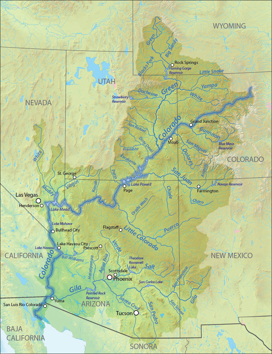
Leaving the dramatic canyons of Utah, the Colorado River enters the more arid regions of the lower basin, where its waters are increasingly managed and utilized for a burgeoning population and vast agricultural lands.
Arizona: The Grand Canyon State’s Jewel
Arizona is perhaps most famously associated with the Colorado River due to the presence of the Grand Canyon. This natural wonder, carved by the river over millions of years, is a UNESCO World Heritage Site and one of the most iconic landmarks in the world. The river flows for over 277 miles through the Grand Canyon, creating a spectacle of immense scale and beauty. Beyond the Grand Canyon, the river forms a significant portion of the border between Arizona and Nevada, and then between Arizona and California. The Hoover Dam, a marvel of engineering, and Lake Mead, its vast reservoir, are located on the Colorado River at the border of Arizona and Nevada, playing a critical role in water management and power generation for the region. The river’s presence in Arizona is deeply intertwined with its identity, supporting both natural ecosystems and significant human settlements.
New Mexico: The Land of Enchantment’s Eastern Edge
While the main stem of the Colorado River does not directly flow through New Mexico, a significant portion of the river’s drainage basin extends into the northwestern part of the state. Key tributaries like the San Juan River originate in the San Juan Mountains of Colorado and flow through New Mexico before eventually joining the Colorado River in Utah. This contribution from New Mexico is part of the upper basin’s water supply, highlighting the interconnectedness of the entire river system across state lines. The arid landscapes of New Mexico also depend on the water resources managed by the basin, even if the main river is geographically distant.
Nevada: A Thirsty Neighbor
The Colorado River forms a significant part of the border between Nevada and Arizona. The Hoover Dam and Lake Mead are prime examples of the river’s impact on Nevada, providing essential water for the rapidly growing Las Vegas metropolitan area and supporting industries and tourism. The river’s managed flow and the creation of Lake Mead have transformed the desert landscape, enabling significant human development. Though Nevada is one of the driest states in the U.S., the Colorado River is its most critical water source, making its management a paramount concern.
California: The Golden State’s Artery
California is the southernmost state on the main stem of the Colorado River. The river forms the border between California and Arizona for a considerable stretch before flowing into Mexico. Historically, the Colorado River has been a lifeline for southern California, providing water for the vast agricultural regions of the Imperial Valley and for major urban centers like Los Angeles. The Imperial Dam, located on the Colorado River near the US-Mexico border, diverts water into the All-American Canal, which is crucial for irrigating millions of acres of farmland in California. The river’s diversion and management in California have been central to the state’s agricultural and economic development, though they also highlight the intense competition for this precious resource.

The River’s Enduring Legacy
The journey of the Colorado River through these seven states is a narrative of geological marvels, ecological resilience, and human ingenuity. From the snow-capped peaks of the Rocky Mountains to the arid plains of the Southwest, the river’s influence is profound. It shapes landscapes, sustains diverse ecosystems, and provides essential water for millions of people and vast agricultural lands. Recognizing the states that the Colorado River runs through is more than just a geographical exercise; it is an acknowledgment of a shared resource and a collective responsibility to manage it sustainably for generations to come. The river’s path is a constant reminder of the interconnectedness of natural systems and the critical role water plays in the life and prosperity of the American West.
LifeOutOfTheBox is a participant in the Amazon Services LLC Associates Program, an affiliate advertising program designed to provide a means for sites to earn advertising fees by advertising and linking to Amazon.com. Amazon, the Amazon logo, AmazonSupply, and the AmazonSupply logo are trademarks of Amazon.com, Inc. or its affiliates. As an Amazon Associate we earn affiliate commissions from qualifying purchases.