
Mesa Verde National Park, a UNESCO World Heritage site, stands as a testament to human ingenuity and the enduring spirit of ancient peoples. Its location, nestled within the southwestern corner of the state of Colorado, is as integral to its mystique as the remarkably preserved cliff dwellings that draw visitors from across the globe. Understanding where Mesa Verde is situated is the first step in appreciating its unique geological setting, its cultural significance, and the logistical considerations for planning a visit to this extraordinary archaeological preserve.
Geographic Placement in Southwestern Colorado
Mesa Verde National Park is strategically positioned in Montezuma County, Colorado, approximately 35 miles east of the Arizona border and about 20 miles north of the New Mexico border. This locale places it squarely within the Four Corners region, a unique quadripoint where the boundaries of four U.S. states converge. The park itself is situated atop the southern end of the Mesa Verde plateau, a sprawling tableland that rises dramatically from the surrounding landscape. The Spanish translation of “Mesa Verde” is “green table,” an apt description for the flat-topped mountain covered in piñon pine and juniper forests.
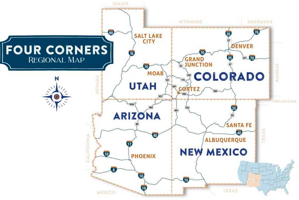
The park’s elevation ranges from approximately 7,000 feet (2,134 meters) to over 8,500 feet (2,591 meters) above sea level. This significant elevation contributes to the park’s distinct climate, characterized by warm summers, cold winters, and a semi-arid environment. The landscape is rugged and characterized by deep canyons, steep mesas, and a dramatic juxtaposition of desert flora and alpine forests. The primary access points to the park are from the north, via Cortez, Colorado, and from the south, though this route is less direct.
Proximity to Major Cities and Transportation Hubs
While Mesa Verde National Park is a remote destination, its location in southwestern Colorado means it is accessible via several regional transportation networks. The nearest major airport is Durango–La Plata County Airport (DRO), located about 50 miles east of the park. This airport offers commercial flights, primarily from hubs like Denver International Airport. Visitors flying into DRO can then rent a car to drive to Mesa Verde.
Another option, though requiring a longer drive, is Grand Junction Regional Airport (GJT) in Colorado, situated approximately 175 miles to the northwest. For those traveling from the south, airports in Flagstaff, Arizona, or Albuquerque, New Mexico, are also potential gateways, though these are considerably further away.
The closest significant towns to Mesa Verde National Park are Cortez, Colorado, to the west, and Mancos, Colorado, to the southeast. These towns offer essential services for travelers, including lodging, dining, and supplies. The park entrance is easily accessible from these communities, making them popular staging points for explorations of Mesa Verde and the surrounding Four Corners area.
Navigating to Mesa Verde National Park
The journey to Mesa Verde is an integral part of the experience, often involving scenic drives through the diverse landscapes of southwestern Colorado. Understanding the primary routes will ensure a smooth and enjoyable arrival.
Access from the North via Cortez
The most common and direct route to Mesa Verde National Park is from the north, typically through the town of Cortez, Colorado. Travelers arriving in Cortez via U.S. Highway 160 will find clear signage directing them to the park entrance. From Cortez, it’s a drive of approximately 8 miles east on Highway 160 to the junction with State Highway 160 Spur, which leads directly to the park’s main entrance. This route offers a relatively straightforward approach, with services available in Cortez for last-minute needs.
Access from the East via Durango
Another common approach is from the east, originating from Durango, Colorado. Travelers follow U.S. Highway 160 West for approximately 45 miles to Mancos, and then continue west for another 15 miles to Cortez. Alternatively, from Durango, one can take Highway 160 West to Highway 184 West towards Mancos, then rejoin Highway 160 West to Cortez, before taking the park spur. This route offers more opportunities to experience the wider San Juan Basin region and its charming towns.
Access from the South

While less direct, visitors may also approach Mesa Verde from the south, crossing from New Mexico. This typically involves traveling north on U.S. Highway 491 and then heading east on U.S. Highway 160 towards Cortez. This route might be preferred by those exploring other attractions in northern New Mexico, such as Chaco Culture National Historical Park.
The Park’s Internal Geography and Layout
Once inside the park boundaries, visitors will discover a vast landscape with distinct features that house the archaeological wonders. The park spans over 52,000 acres, and its most famous sites are situated on or accessible from the mesa itself.
The Mesa Top and Cliff Dwellings
The heart of Mesa Verde National Park lies on the plateau, where ancient Pueblo people constructed their homes. The main road, Mesa Top Loop Road, offers spectacular views and access to several significant sites, including Mesa Top View and Sun Point View. This loop road, which is approximately 6 miles long, takes visitors past various ancestral Pueblo sites and overlooks, providing context for the dwellings below.
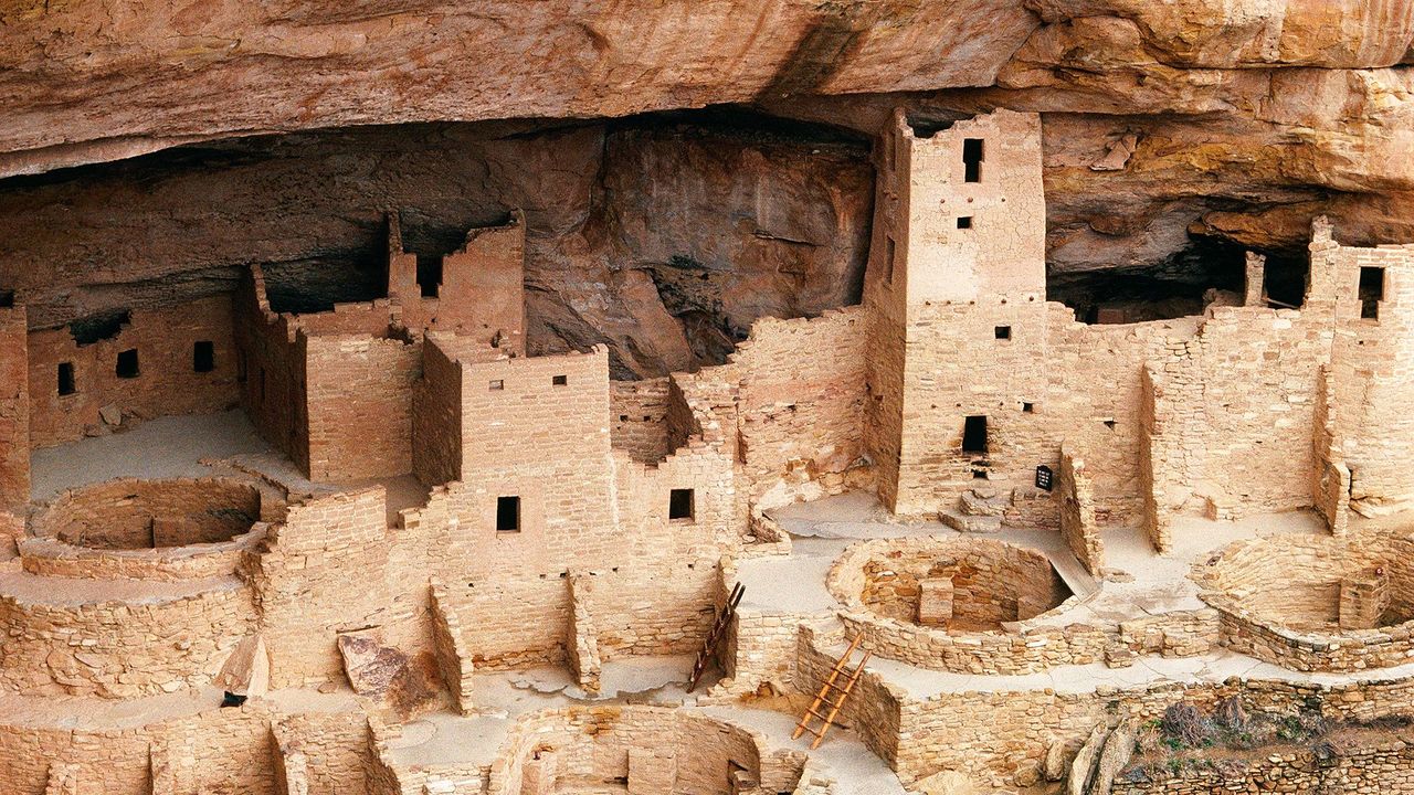
The most iconic cliff dwellings, such as Cliff Palace, Balcony House, and Spruce Tree House, are nestled within the alcoves of the canyon walls. Access to these sites often involves hiking, climbing ladders, and navigating narrow passages, adding an element of adventure to the historical exploration. These dwellings, constructed between 1200 and 1300 CE, represent the pinnacle of ancestral Pueblo architecture and engineering.
Chapin Mesa and its Archaeological Museum
Chapin Mesa is a central area within the park that hosts the Mesa Verde Museum, providing invaluable context and interpretation of the archaeological findings. Adjacent to the museum are several important sites, including Spruce Tree House, which is often accessible year-round. Chapin Mesa offers a comprehensive overview of the ancestral Puebloan culture, from their daily lives to their agricultural practices and eventual migration.
Wetherill Mesa and Far View Sites
Wetherill Mesa, accessible seasonally, offers further opportunities for exploration, including the impressive Long House and various other smaller sites. The Far View sites, located on the northern end of the mesa, represent an earlier period of ancestral Pueblo habitation and offer insight into community structures and ceremonial practices. These areas, while perhaps less dramatic than the cliff dwellings, are crucial for understanding the long and complex history of human presence in Mesa Verde.
Understanding the Context: The Four Corners Region
Mesa Verde’s location within the Four Corners region is not merely a geographical fact but a key to understanding its cultural context. This area is rich in archaeological and cultural heritage, sharing a common history with other significant ancestral Puebloan sites.
The Ancestral Puebloan Legacy
The people who built Mesa Verde were part of a larger cultural group known as the ancestral Puebloans, who inhabited the Four Corners region for over 700 years. Their civilization flourished, developing sophisticated agricultural techniques, intricate social structures, and remarkable architectural achievements. The reasons for their eventual departure from Mesa Verde around 1300 CE remain a subject of ongoing research, with theories ranging from drought and resource depletion to social and environmental pressures.
Influence of Nearby Landmarks
The presence of other significant ancestral Puebloan sites in the vicinity, such as Chaco Culture National Historical Park in New Mexico and Hovenweep National Monument along the Utah-Colorado border, underscores the broad reach and influence of this ancient civilization. Mesa Verde is an indispensable piece of this larger historical puzzle, offering a unique and well-preserved glimpse into a vanished world. The park’s location in southwestern Colorado places it at the nexus of a profound cultural landscape, inviting visitors to explore not just a single park, but a region steeped in history and mystery.
LifeOutOfTheBox is a participant in the Amazon Services LLC Associates Program, an affiliate advertising program designed to provide a means for sites to earn advertising fees by advertising and linking to Amazon.com. Amazon, the Amazon logo, AmazonSupply, and the AmazonSupply logo are trademarks of Amazon.com, Inc. or its affiliates. As an Amazon Associate we earn affiliate commissions from qualifying purchases.