
The question of where Hurricane Helene made landfall in Florida is a critical one for residents, emergency responders, and anyone planning travel to the Sunshine State during hurricane season. While the direct impact of a hurricane can vary significantly, understanding its trajectory and the areas most affected is paramount for preparedness and recovery. Hurricane Helene, like many powerful storms, presents a complex scenario that requires a detailed look at its path and the specific regions that bore the brunt of its fury.
Understanding Hurricane Paths and Landfall
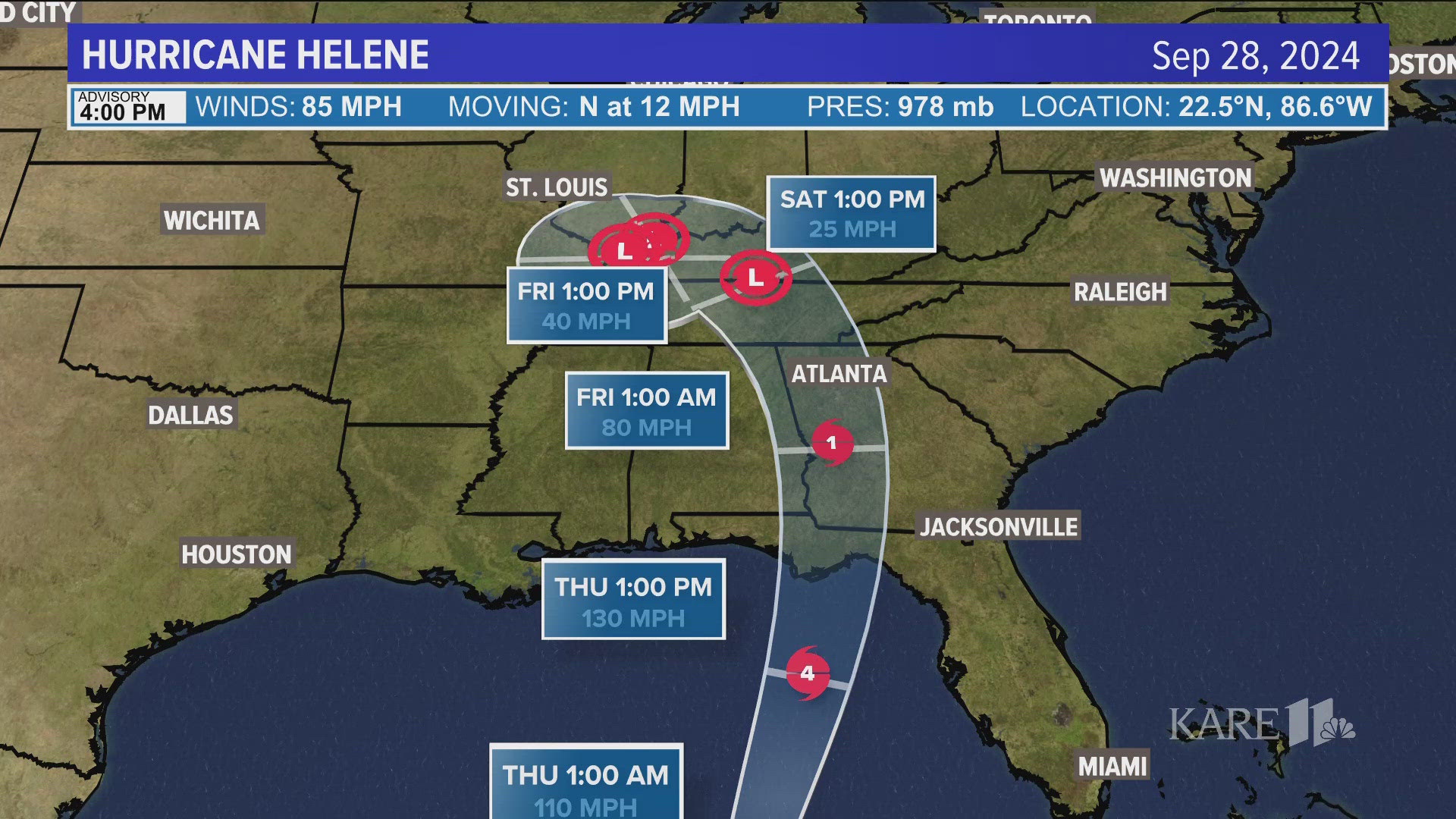
Hurricanes are dynamic weather systems, and their paths can be influenced by a multitude of atmospheric factors. Tracking a hurricane involves monitoring its development in the Atlantic Ocean, its westward or northward movement, and the steering currents that dictate its ultimate destination. When a hurricane is forecast to impact a region like Florida, emergency management agencies and meteorologists focus intensely on the projected landfall point. This point is not always a single, precise spot but can often be a stretch of coastline, with the storm’s immense size meaning that impacts are felt far beyond the immediate center.
Factors Influencing Landfall
Several key factors contribute to a hurricane’s landfall location:
- Steering Currents: High-pressure systems and prevailing winds in the upper atmosphere act like highways, guiding hurricanes. A strong ridge of high pressure can push a storm westward, while a trough can pull it northward.
- Sea Surface Temperatures: Warm ocean waters provide the fuel for hurricanes. Areas with exceptionally warm waters can intensify a storm as it approaches land.
- Interaction with Other Weather Systems: The presence of other storms or frontal boundaries can alter a hurricane’s speed and direction.
The intensity and size of a hurricane also play a significant role in the breadth of its impact. Even if the eye of Hurricane Helene were to make landfall at a specific point, its associated winds, heavy rainfall, and storm surge could affect hundreds of miles of coastline and inland areas.
Hurricane Helene’s Projected and Actual Impact Zones in Florida
To understand where Hurricane Helene hit Florida, it’s essential to distinguish between its projected path and its actual landfall. Meteorologists use sophisticated computer models to predict a storm’s course, but these are always subject to change. Real-time observations from satellites, aircraft, and reconnaissance missions provide crucial data to refine these predictions.
Pre-Landfall Projections
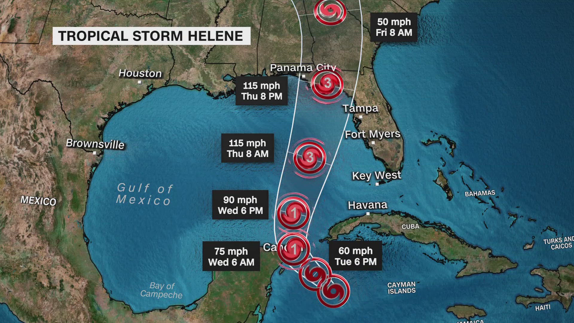
In the days leading up to potential landfall, various forecasting centers, such as the National Hurricane Center (NHC) in the United States, issue advisories and track cones of uncertainty. These projections offer a general idea of where the storm is most likely to track and where impacts might occur. For Hurricane Helene, these projections would have indicated a probability of landfall along different sections of Florida’s coast, from the panhandle to the Keys. Residents in these projected zones would be advised to prepare for potential impacts, including evacuations if necessary.

Actual Landfall and Immediate Impact
When Hurricane Helene made its eventual landfall, its precise location would have been pinpointed by meteorologists. This is the point where the storm’s center, or eye, crossed the coastline. However, the “hit” of a hurricane extends far beyond the eye. Tropical-storm-force winds, which can cause significant damage, often extend hundreds of miles from the center. Heavy rainfall, leading to inland flooding, can also be a major threat. Storm surge, the abnormal rise of water generated by a storm’s winds, is a particularly dangerous aspect, capable of inundating coastal communities.
For Hurricane Helene, the specific location of landfall would dictate which counties and cities experienced the most severe conditions. For instance, a landfall in the Florida Panhandle would mean areas like Pensacola, Panama City, and Destin would be directly in the storm’s path, facing its strongest winds and highest storm surge. A landfall further south, perhaps along the Gulf Coast near Tampa or Fort Myers, would impact different communities with their own unique vulnerabilities.
Assessing the Damage and Recovery Efforts
Following any hurricane landfall, the focus shifts to assessing the damage and initiating recovery efforts. The areas that experienced the most direct hit from Hurricane Helene would have seen the most significant structural damage, power outages, and disruptions to daily life.
Damage Assessment
Damage assessment is a multi-faceted process involving:
- Aerial Surveys: Drones and aircraft provide an overview of widespread damage, especially in hard-to-reach areas.
- Ground Teams: First responders, insurance adjusters, and government officials survey affected neighborhoods to document property damage.
- Infrastructure Review: Assessment of damage to roads, bridges, power lines, and communication networks is crucial for restoring essential services.
The type of damage is also contingent on the storm’s characteristics. High winds can tear roofs off buildings, uproot trees, and turn debris into dangerous projectiles. Torrential rains can lead to flash floods and prolonged inundation, causing extensive water damage. Storm surge can devastate coastal properties, eroding beaches and flooding entire communities.
Recovery and Rebuilding
Recovery efforts in the wake of Hurricane Helene would involve a coordinated response from local, state, and federal agencies. This includes:
- Emergency Services: Search and rescue operations, provision of essential supplies like food, water, and medical aid.
- Infrastructure Repair: Restoring power, water, and communication services as quickly as possible.
- Debris Removal: Clearing roads and public spaces of fallen trees and wreckage.
- Financial Assistance: Providing aid to individuals and businesses through programs like those offered by the Federal Emergency Management Agency (FEMA).
- Long-Term Rebuilding: This phase involves not only rebuilding damaged structures but also implementing mitigation strategies to enhance resilience against future storms. This might include updating building codes, improving drainage systems, and restoring natural coastal defenses like dunes and wetlands.
The resilience of Florida communities is often tested by hurricanes, but the spirit of cooperation and determination to rebuild is a hallmark of post-storm recovery. Understanding the specifics of where a storm like Helene made landfall is the first step in appreciating the challenges and triumphs of these recovery processes.
LifeOutOfTheBox is a participant in the Amazon Services LLC Associates Program, an affiliate advertising program designed to provide a means for sites to earn advertising fees by advertising and linking to Amazon.com. Amazon, the Amazon logo, AmazonSupply, and the AmazonSupply logo are trademarks of Amazon.com, Inc. or its affiliates. As an Amazon Associate we earn affiliate commissions from qualifying purchases.