
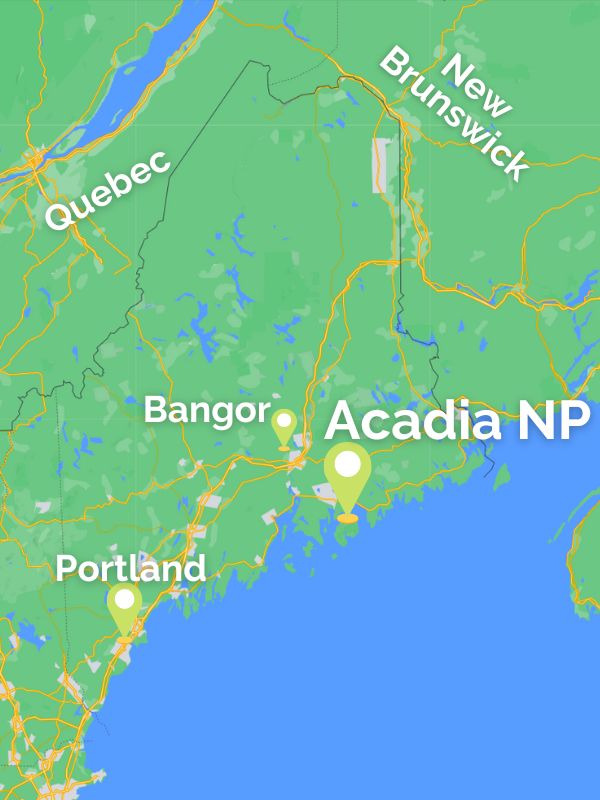
Spanning the rugged, windswept coastline of the North Atlantic, Acadia National Park stands as the crown jewel of the American Northeast. For travelers planning their inaugural excursion to this geological marvel, the first question is often one of geography. Acadia is primarily situated on Mount Desert Island, located along the mid-coast region of Maine. While the park encompasses several smaller satellite areas, including the Schoodic Peninsula and parts of Isle au Haut, its heart beats within the granite peaks and coastal forests of this iconic island.
The Geography of Acadia National Park
Understanding the layout of this coastal sanctuary is essential for anyone hoping to navigate its diverse landscapes effectively. The park is characterized by a unique collision of mountainous terrain and deep-sea inlets, a result of ancient glacial activity.

Mount Desert Island: The Main Hub
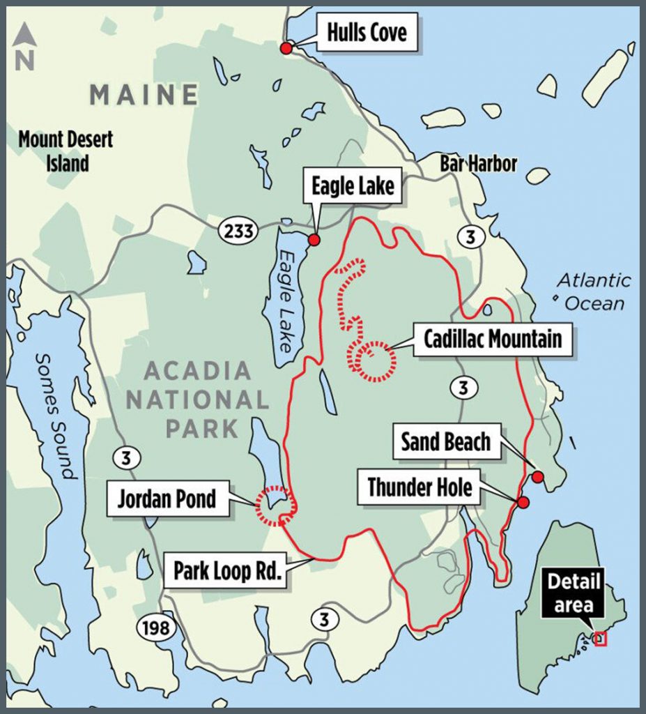
The vast majority of the park’s landmass, trails, and visitor amenities are concentrated on Mount Desert Island. This island is connected to the mainland by a short causeway, making it easily accessible by car. The geography here is a dramatic mix of exposed pink granite cliffs, sparkling freshwater lakes, and spruce-fir forests. Most visitors base themselves in nearby gateway towns like Bar Harbor, which serves as the primary access point for the most popular segments of the park, including the famous Park Loop Road.
The Schoodic Peninsula
Often overlooked by first-time visitors, the Schoodic Peninsula represents the only portion of Acadia National Park located on the mainland. Situated directly across Frenchman Bay from the main island, this area offers a more tranquil, rugged experience. The granite headlands here crash into the ocean with incredible force, providing a pristine alternative to the bustling tourist centers of the primary island. Accessing the peninsula requires a scenic drive through quintessential coastal fishing villages, further immersing travelers in the local atmosphere of Downeast Maine.
Reaching the Park: Navigation and Travel Tips
Getting to this remote corner of New England requires a bit of logistical planning. Because the park is spread across islands and mainland reaches, relying on a personal vehicle is typically the most efficient way to see the various sections, though public transit alternatives exist during the peak summer months.
Airports and Transit Hubs
Most travelers flying into the region will utilize Bangor International Airport, located approximately 50 miles northwest of the park. From there, the drive to the entrance of the park is a relatively straightforward journey through the rural beauty of the Maine countryside. For those arriving from further afield, Portland International Jetport is another common choice, though it necessitates a significantly longer drive along the Atlantic Ocean coastline.
Navigating the Park Roads
The most iconic way to experience the geography of Acadia National Park is by driving the Park Loop Road. This 27-mile thoroughfare acts as a primary artery, connecting many of the most famous landmarks, including Sand Beach, Thunder Hole, and the trailhead for Jordan Pond. While the road is masterfully engineered to showcase the park’s beauty, it can become congested during peak summer months, emphasizing the importance of planning travel times to avoid mid-day bottlenecks at popular scenic overlooks.
Top Geographical Features and Landmarks
The allure of this national park lies in its verticality and proximity to the sea. Unlike many inland wilderness areas, Acadia National Park places the visitor at the intersection of high alpine terrain and the salt-sprayed shoreline.
Cadillac Mountain
Rising as the highest point along the North Atlantic seaboard, Cadillac Mountain is a mandatory destination. Located near the center of Mount Desert Island, it offers panoramic views of the surrounding archipelago. It is perhaps best known for being one of the first places in the United States to see the sunrise during the autumn and winter months, drawing crowds of photographers and outdoor enthusiasts to its summit.
The Carriage Roads
Woven throughout the interior of the park are the historic Carriage Roads. Commissioned by John D. Rockefeller Jr., these stone-crushed paths span 45 miles and are closed to motorized vehicles. They represent a unique logistical feat, using innovative engineering—such as arched stone bridges—to navigate the rugged, uneven topography of the island. Exploring these paths by bicycle or foot provides a quiet, introspective way to appreciate the deep woods and hidden vistas that are otherwise inaccessible by car.
Coastal Inlets and Shoreline
The interplay between the land and the ocean is the defining characteristic of the park’s location. The Gulf of Maine influences the climate, the vegetation, and the recreational activities available. From the sheltered coves that host historic lobster boats to the exposed, wave-battered cliffs at Otter Cliff, the geographic diversity is staggering. Hikers can spend their morning trekking through the boreal forests on the slopes of The Bubbles and their afternoon walking along the tidal pools at the edge of the Atlantic Ocean.
Seasonal Considerations for Your Visit
Because of its northern latitude, the location of Acadia National Park dictates a strict seasonal calendar. Planning a trip involves choosing between the vibrant, high-traffic summer season and the quiet, introspective shoulder seasons of spring and autumn.
- Summer (June – August): This is when the park is most accessible. All roads and facilities are open, and the Island Explorer shuttle bus provides reliable service across the island. The weather is generally mild, though coastal fog can descend rapidly, adding a moody, ethereal quality to the scenery.
- Autumn (September – October): Many locals consider this the “golden time” to visit. As the foliage turns to brilliant shades of crimson and gold, the crowds begin to thin, and the air becomes crisp. It is an ideal time for hiking, as the humidity drops and the landscape takes on a stark, beautiful clarity.
- Winter (November – April): For the adventurous traveler, the winter offers a solitary experience. While many roads are closed due to snow and ice, the park remains open for cross-country skiing and snowshoeing. Visiting during this time requires a high degree of preparation and self-sufficiency, as most visitor services are suspended until the arrival of spring.
By understanding the distinct zones of Mount Desert Island, the Schoodic Peninsula, and the remote Isle au Haut, visitors can tailor their experience to match their own pace. Whether you are looking for the challenge of a strenuous mountain climb, a peaceful bike ride along historic paths, or simply a breathtaking vantage point to watch the sunrise over the vast expanse of the Atlantic Ocean, the geography of this park offers endless discovery. It remains a testament to the rugged, untamed spirit of Maine, inviting all who journey to its borders to witness the timeless dance between land and sea.
LifeOutOfTheBox is a participant in the Amazon Services LLC Associates Program, an affiliate advertising program designed to provide a means for sites to earn advertising fees by advertising and linking to Amazon.com. Amazon, the Amazon logo, AmazonSupply, and the AmazonSupply logo are trademarks of Amazon.com, Inc. or its affiliates. As an Amazon Associate we earn affiliate commissions from qualifying purchases.