
For travelers planning a visit to the Crescent City, understanding the geography of New Orleans is essential. While the city is world-renowned for its jazz, Creole cuisine, and historic architecture, its relationship with water is a defining characteristic of its existence. Situated between the Mississippi River and Lake Pontchartrain, the city’s complex drainage systems and unique elevation levels mean that certain neighborhoods are more susceptible to water accumulation during heavy rainfall than others.
Understanding the Topography and Drainage Challenges
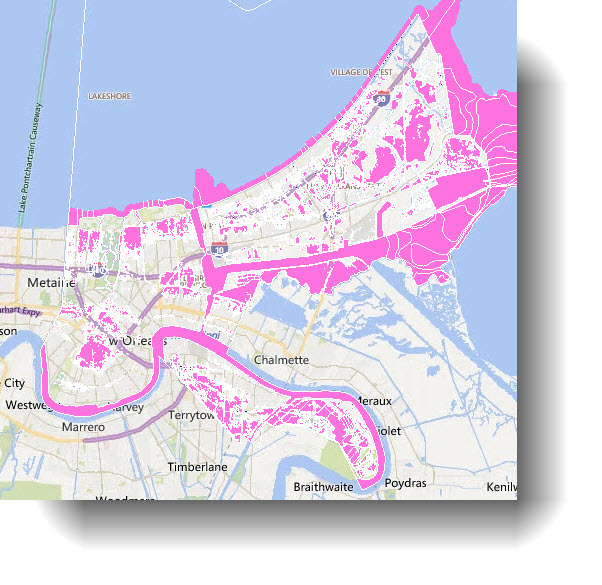
New Orleans is often described as a bowl, with significant portions of the city sitting at or below sea level. This topographical reality makes efficient water management a constant priority for the United States Army Corps of Engineers and local city planners.

The Low-Lying Neighborhoods
Historically, areas that were developed later in the city’s expansion, particularly those built on reclaimed swampland, often sit at lower elevations. Neighborhoods like Gentilly and parts of the Lower Ninth Ward have historically faced greater challenges with localized flooding. During intense tropical storms or standard heavy afternoon downpours—common during the summer months—these areas can experience rapid surface water accumulation.
The Role of Infrastructure
The city relies on an extensive network of pump stations to push water out of the interior and toward the surrounding water bodies. When these systems are overwhelmed by an extraordinary volume of rain in a short window of time, streets in low-lying areas often become impassable for several hours. For visitors, understanding these infrastructure limitations is part of navigating the city’s unique, albeit occasionally challenging, environment.
Historic Districts and Elevation Advantages
Travelers primarily stick to the French Quarter and the Garden District, and there is a geographical reason why these neighborhoods became the city’s commercial and residential hubs.
The Natural Levee
The French Quarter sits upon the natural levee of the Mississippi River. Because this area was the first to be settled, builders chose the highest ground available—the silt deposits left by the river over centuries. Consequently, the French Quarter is generally the most resilient part of the city when it comes to standard rain events.
High-Ground Neighborhoods
Similarly, areas along St. Charles Avenue and the Uptown region tend to sit on higher ground than the areas closer to the lakefront. Because these sections of New Orleans were developed along the river’s path, they benefit from slightly more elevation, providing a level of natural protection that neighborhoods developed in the 20th century lack.

Strategic Travel Planning and Safety Tips
For those exploring Louisiana, it is important to realize that “flooding” in this city is often a temporary, localized phenomenon rather than a constant state of being. However, knowing where to be—and when—can make a significant difference in your trip quality.
Navigating the Summer Storms
New Orleans is famous for its sudden, violent afternoon thunderstorms, especially from June through September. If you find yourself in the city during these months, keep an eye on local news outlets. If a heavy rain event is predicted, avoid driving through underpasses or low-lying streets in the Broadmoor or Mid-City districts, as these areas can quickly become traps for vehicles.
The Importance of Transit
One of the best ways to explore the city without worrying about street flooding is to utilize public transit. The New Orleans Streetcar system, particularly the St. Charles Streetcar Line, travels along higher ground. Relying on these historic transit methods not only adds a charming layer to your vacation experience but also helps you avoid the stress of navigating flooded streets during a downpour.
Checking Forecasts Before Heading Out
Before you set off to explore the Audubon Zoo or the New Orleans Museum of Art, check the local weather apps. If you are staying in a neighborhood outside of the tourist corridor, consult with your hosts or hotel front desk staff about current street conditions. They are well-versed in which roads tend to collect water and can provide the most accurate, real-time advice for your specific location.
Recognizing the Resilience of the City
It is impossible to talk about flooding in New Orleans without acknowledging the immense effort put into flood protection since 2005. The Hurricane and Storm Damage Risk Reduction System is a massive, multi-billion-dollar network of levees, floodwalls, and gates designed to protect the city from large-scale storm surges.
Living With Water
For the local population, flooding is a manageable, albeit recurring, reality. The city has become a hub for water management innovation, integrating green infrastructure like bioswales and permeable pavements into the urban landscape. This “living with water” philosophy is gradually reshaping how the city handles excess rain, making areas like Treme and Marigny more resilient than they were in decades past.
Advice for Tourists
Do not let the fear of flooding deter you from visiting one of the most culturally significant cities in the United States. Millions of people visit every year, and the vast majority encounter nothing more than a temporary inconvenience during a summer shower. By choosing accommodations in historically high-ground districts and paying attention to the weather during the peak of Hurricane Season, travelers can safely enjoy everything the city has to offer.
Summary for Travelers
When selecting where to stay or planning your itinerary, remember the elevation rule: if you are closer to the Mississippi River, you are likely on higher, more stable ground. If you are venturing deep into Lakeview or other areas approaching Lake Pontchartrain, be mindful of the weather reports during heavy rain.
The geography of New Orleans is a fascinating part of its character. It is a city that fights to exist between the river and the lake, a fact that makes every visit an opportunity to appreciate the sheer ingenuity and spirit of the people who call this unique place home. By staying informed and respecting the local environment, you can have a seamless, memorable, and safe adventure in the Big Easy.
LifeOutOfTheBox is a participant in the Amazon Services LLC Associates Program, an affiliate advertising program designed to provide a means for sites to earn advertising fees by advertising and linking to Amazon.com. Amazon, the Amazon logo, AmazonSupply, and the AmazonSupply logo are trademarks of Amazon.com, Inc. or its affiliates. As an Amazon Associate we earn affiliate commissions from qualifying purchases.