California State Route 1, more commonly known as the Pacific Coast Highway (PCH), is an iconic American road trip, renowned for its breathtaking coastal vistas, dramatic cliffs, and charming seaside towns. It winds its way along the edge of the continent, offering unparalleled views of the Pacific Ocean. However, the very beauty and ruggedness of its location, particularly through areas like Big Sur, make it susceptible to natural events such as landslides and severe weather, which can lead to temporary closures. For any traveler planning a journey along this legendary route, understanding its current status is paramount to a successful and enjoyable experience.
Navigating the Dynamics of California’s Iconic Highway
The allure of Highway 1 lies in its unpredictable charm, a characteristic that also necessitates vigilance for those eager to traverse it. The California Department of Transportation (Caltrans) is the official body responsible for monitoring and maintaining the highway, and their real-time updates are the most crucial resource for travelers. Understanding the typical reasons for closures and where these are most likely to occur can help in planning your trip effectively and mitigating potential disruptions.
Understanding Potential Closure Causes
The most frequent cause for Highway 1 closures, especially in the central and northern sections, is landslides. The steep, unstable terrain of areas like Big Sur is prone to rockfalls and mudslides, particularly after heavy rainfall. These events can deposit large amounts of debris onto the roadway, rendering it impassable and often requiring extensive cleanup and repair work.
Beyond landslides, severe weather events such as heavy rain, high winds, and even coastal flooding can impact the highway’s integrity and safety. In winter months, increased rainfall can saturate the hillsides, leading to the aforementioned slides. Coastal storms can create hazardous driving conditions due to reduced visibility, strong crosswinds, and potential for waves to reach the roadway. Wildfires, while less common as a direct cause of road closure, can also impact access to certain sections due to smoke, evacuation orders, or damage to infrastructure near the highway.
Key Areas Prone to Closures
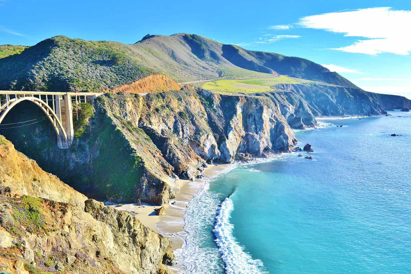
While stretches of Highway 1 can be affected, certain sections are historically more susceptible to closures due to their geographical characteristics. The roughly 90-mile stretch through Big Sur is arguably the most well-known for its vulnerability. This segment features dramatic cliffs that plunge into the ocean, with winding roads carved into the mountainside. Areas around Bixby Creek Bridge, McWay Falls, and the numerous overlooks are breathtaking but also exist within geologically active zones.
Further north, sections between Monterey and Carmel-by-the-Sea, and between San Simeon and Cambria in the south, can also experience temporary disruptions, though typically less frequently than the core Big Sur corridor. Understanding these specific zones allows travelers to anticipate potential detours or adjustments to their itinerary.
Real-Time Information Sources for Highway 1 Status
In the age of instant information, staying updated on the status of Highway 1 is easier than ever, provided you know where to look. Relying on official and up-to-date sources is critical to avoid disappointment and ensure safety. These resources are constantly refreshed by Caltrans and other relevant agencies, providing the most accurate picture of the highway’s condition.
Caltrans: The Official Source
The California Department of Transportation, or Caltrans, is the definitive authority on highway conditions throughout the state. Their website and dedicated tools are designed to provide travelers with the most current information regarding closures, construction, and incidents.
Caltrans QuickMap: This is arguably the most valuable tool for real-time highway information. Caltrans QuickMap offers a dynamic map interface displaying traffic conditions, incidents, construction, and importantly, highway closures. Users can zoom into specific areas of Highway 1 to see the exact status of the road. Color-coded indicators clearly show whether lanes are open, closed, or experiencing delays.
Caltrans Social Media: Caltrans actively uses social media platforms like Twitter to disseminate urgent updates regarding highway conditions, including significant closures. Following the relevant Caltrans district accounts for the areas you plan to travel through can provide timely notifications.
Caltrans Public Information: For more detailed information or to speak with a representative, Caltrans also offers public information lines. While QuickMap is excellent for a quick overview, direct contact can be helpful for understanding the scope of repairs or expected reopening times for major closures.

Alternative Resources and Traveler Alerts
While Caltrans is the primary source, several other resources can supplement your information gathering, particularly from a traveler’s perspective.
California State Parks: For closures affecting access to specific state parks along Highway 1, such as Julia Pfeiffer Burns State Park or Pfeiffer Big Sur State Park, checking the California State Parks website can provide localized alerts. These parks often have their own access roads or trail closures that may be impacted by broader highway conditions.
Local Tourism Websites: Many towns and regions along Highway 1, such as Monterey, Carmel-by-the-Sea, San Simeon, and Morro Bay, maintain visitor information websites. These sites often feature updates on local road conditions and can offer advice on navigating temporary closures and recommended alternative routes. They can also be invaluable for understanding the impact of a closure on local businesses and attractions.
Navigation Apps: While not official sources, popular navigation applications like Google Maps and Waze often incorporate Caltrans data and user-reported incidents. They can be a helpful tool for identifying real-time traffic and potential detours as you drive, but should always be cross-referenced with official Caltrans information for definitive closure status.
Planning Your Highway 1 Journey with Current Conditions in Mind
A road trip along Highway 1 is a bucket-list experience for many, and with diligent planning, even temporary closures can be navigated. The key is to be flexible, informed, and to have backup plans in place. Understanding the potential for closures, knowing how to access real-time information, and being prepared to adapt your itinerary are all crucial components of a successful journey along this magnificent route.
Pre-Trip Preparation and Checking Status
Before embarking on your trip, especially if your itinerary heavily relies on Highway 1, it is imperative to check Caltrans QuickMap for the most up-to-date information. It is advisable to do this a day or two before your departure and then again on the morning of your travel. Pay close attention to the specific segments you intend to drive, particularly the areas within Big Sur.
Consider the time of year. Winter and early spring typically see more rainfall, increasing the likelihood of landslides. Summer and fall generally offer more stable conditions, but unexpected events can still occur.
Developing Flexible Itineraries and Detour Strategies
Given the dynamic nature of Highway 1, a rigid itinerary can quickly become unworkable. Embrace flexibility and have alternative plans ready.
Southbound vs. Northbound: If a significant section of Highway 1 is closed, you may need to decide whether to drive the open segments from the north and south and adjust your overall travel time or explore alternative routes entirely.
Inland Detours: For closures in Big Sur, the primary inland detour is State Route 46, which connects Paso Robles on US Route 101 to Cambria on Highway 1. Another significant detour involves taking US Route 101 north or south to bypass the closed section, and then rejoining Highway 1 at accessible points. Be aware that these detours can add significant travel time and may not offer the same scenic views as the coastal highway.
Accommodation and Activity Adjustments: If a closure impacts your access to planned accommodations or attractions, research alternative lodging in nearby towns or explore nearby attractions that remain accessible. Many visitors choose to base themselves in towns like Monterey, San Luis Obispo, or Santa Barbara and then drive the open sections of Highway 1 as day trips.

Embracing the Journey, Not Just the Destination
Ultimately, the spirit of a Highway 1 road trip is about the journey itself. While closures can be frustrating, they also serve as a reminder of the raw, untamed beauty of the California coast. By staying informed and remaining adaptable, travelers can still experience the magic of this legendary highway, making memories that are as resilient and awe-inspiring as the landscape itself. Whether it’s navigating a temporary closure or enjoying an unobstructed drive, the adventure along Highway 1 is an unforgettable experience.
LifeOutOfTheBox is a participant in the Amazon Services LLC Associates Program, an affiliate advertising program designed to provide a means for sites to earn advertising fees by advertising and linking to Amazon.com. Amazon, the Amazon logo, AmazonSupply, and the AmazonSupply logo are trademarks of Amazon.com, Inc. or its affiliates. As an Amazon Associate we earn affiliate commissions from qualifying purchases.