
Crater Lake Oregon stands as a testament to the raw power and breathtaking artistry of nature. Nestled within the Cascade Range of Oregon, this sapphire-blue gem is the deepest lake in the United States and a truly awe-inspiring natural wonder. Its formation is a dramatic saga written in volcanic ash and molten rock, a story that unfolds over millennia, culminating in the pristine beauty we can witness today. For travelers and nature enthusiasts alike, understanding the geological journey that birthed Crater Lake adds an invaluable layer of appreciation to any visit. This article delves into the captivating geological history of how this iconic landmark came to be, exploring the colossal volcanic events and the subsequent processes that sculpted its unforgettable landscape.

The Volcanic Genesis: Mount Mazama’s Fiery Past
The story of Crater Lake begins with a colossal volcano named Mount Mazama. This massive stratovolcano, once towering over 12,000 feet, was an active and imposing presence in the Oregon landscape for thousands of years. Like many volcanoes in the Cascade Range, Mount Mazama was part of the Pacific Ring of Fire, a horseshoe-shaped zone characterized by frequent volcanic activity and earthquakes. Its formation was a slow, incremental process, with eruptions layering lava and ash upon each other, building its impressive stature over countless cycles.
Eruptions and Pyroclastic Flows
The life of Mount Mazama was not always peaceful. It experienced numerous eruptive phases, some of which were incredibly violent. The volcano spewed ash, cinders, and lava, shaping the surrounding terrain. Evidence of these past eruptions can still be seen in the geological formations around the lake. The most significant events, however, were the massive eruptions that occurred tens of thousands of years ago, leading to its ultimate demise.
These cataclysmic events were characterized by pyroclastic flows – fast-moving currents of hot gas, ash, and rock that surged down the volcano’s slopes. These flows were devastating, capable of incinerating everything in their path and drastically altering the landscape. Geologists have identified distinct layers of ash and pumice from these eruptions that are found scattered across vast areas of Oregon and beyond, serving as silent witnesses to the volcano’s immense power. The composition of these ejected materials, primarily basaltic and andesitic, reveals the type of magma that fueled Mount Mazama’s fury.
The Climactic Collapse: Caldera Formation
The most pivotal moment in the formation of Crater Lake occurred approximately 7,700 years ago. Following a prolonged period of intense volcanic activity, the magma chamber beneath Mount Mazama became largely depleted. With the support from below significantly weakened, the immense weight of the volcano’s summit became unsustainable.
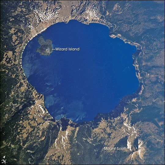
This led to a dramatic and catastrophic collapse. The mountain’s peak essentially imploded, falling inward into the emptied magma chamber. This process is known as caldera formation. The result was a vast, bowl-shaped depression at the summit, measuring approximately five miles wide and nearly a mile deep. The sheer scale of this collapse was staggering, and the ejected material from this final eruption blanketed the surrounding region in thick layers of ash and pumice, an event that geologists refer to as the Mazama eruption. The remnants of Mount Mazama today, the steep, jagged walls surrounding the lake, are the caldera rim, a stark reminder of the mountain that once stood there.
The Birth of a Lake: Precipitation and Purity
Once the colossal collapse of Mount Mazama had subsided, the newly formed caldera was a massive, empty basin. It was not immediately a lake; instead, it was a stark, barren landscape shaped by volcanic destruction. The subsequent transformation into the pristine body of water we know today was a patient, natural process driven by the abundant precipitation in the region and the unique characteristics of the caldera.
Gathering Waters: Snowmelt and Rainfall
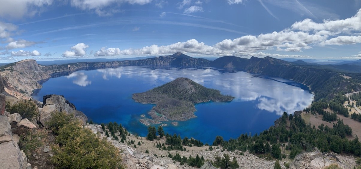
The location of the caldera at a high elevation within the Cascade Range means it receives significant snowfall and rainfall. Over hundreds of years, this accumulated precipitation began to fill the vast depression. Unlike many lakes that are fed by rivers and streams, Crater Lake is primarily fed by snowmelt and rainfall. There are no significant inlets or outlets. Water enters the lake through precipitation and seeps into the ground, and it leaves only through slow evaporation and a small, trickling spring at the base of the caldera wall known as The Pinnacles. This lack of riverine inflow is crucial to the lake’s exceptional clarity.
Unrivaled Clarity: The Absence of Sediments
One of the most remarkable features of Crater Lake is its astonishing clarity and vibrant blue color. This clarity is a direct consequence of its formation and its isolated hydrological system. The caldera walls are composed of volcanic rock that is largely impermeable, preventing significant sediment from washing into the lake. Furthermore, the lack of inflowing rivers means there are no sediment-laden waters introducing silt and debris.
The deep blue hue of the lake is due to the extreme depth and the purity of the water. Water absorbs longer wavelengths of light (reds, oranges, yellows) more readily than shorter wavelengths (blues). In a deep, clear body of water like Crater Lake, the light penetrates deeply, and the blue light is scattered back, creating the intense, captivating color that has become its hallmark. The lake’s average depth of 1,943 feet contributes significantly to this phenomenon. The absence of dissolved organic matter, which would typically give other lakes a greenish tint, further enhances the visual purity.
Post-Formation: Volcanic Resurgence and Iconic Features
While the primary formation of the caldera and the subsequent filling of the lake were monumental events, the geological story of Crater Lake did not end there. The volcanic forces that shaped the region continued to leave their mark, contributing to some of the lake’s most distinctive and memorable features.
Wizard Island and the Phantom Ship
Within the vast expanse of Crater Lake, two prominent volcanic formations stand out: Wizard Island and the Phantom Ship. These are not mere geological accidents but rather remnants of Mount Mazama’s earlier activity and subsequent volcanic resurgence.
Wizard Island is a cinder cone volcano that formed on the floor of the caldera after the main collapse. It is believed to have been created by a series of smaller eruptions that occurred as the magma system was still settling. Standing approximately 764 feet above the lake’s surface, it resembles a miniature volcano within the grander caldera. Its formation is a testament to the lingering volcanic energy in the area, even after the cataclysmic event.
The Phantom Ship is a small, rugged island composed of ancient lava flows that predate the main Mount Mazama caldera collapse. It is a remnant of an older, eroded volcano that was partially submerged during the collapse and has since been sculpted by wave action. Its dramatic, jagged appearance, particularly when shrouded in mist, gives it an ethereal and ghostly quality, hence its name. Both Wizard Island and the Phantom Ship are now popular landmarks and attractions for boat tours and scenic views within Crater Lake National Park.
The Rim Drive and Geological Insights
Today, visitors can experience the grandeur of Crater Lake by driving the scenic Rim Drive. This picturesque road encircles the lake, offering breathtaking viewpoints at every turn. As one travels along the Rim Drive, the geological story of the lake’s formation becomes palpable.
Pullouts and overlooks provide opportunities to observe the caldera walls, study the layers of volcanic ash and rock, and gain a deeper understanding of the forces that sculpted this remarkable landscape. Geologists have meticulously studied the exposed rock formations, piecing together the timeline of eruptions, collapses, and subsequent erosion. The varied rock types, including pumice, ash, and lava flows, tell a story of a dynamic and powerful geological past. The Rim Drive itself is an engineering marvel, carefully designed to showcase the natural beauty while minimizing environmental impact. It allows for easy access to the most stunning vistas, making the geological wonders of Crater Lake accessible to a wide audience, from casual tourists to serious geology enthusiasts. Exploring these viewpoints offers a profound connection to the ancient volcanic forces that created this natural masterpiece.
LifeOutOfTheBox is a participant in the Amazon Services LLC Associates Program, an affiliate advertising program designed to provide a means for sites to earn advertising fees by advertising and linking to Amazon.com. Amazon, the Amazon logo, AmazonSupply, and the AmazonSupply logo are trademarks of Amazon.com, Inc. or its affiliates. As an Amazon Associate we earn affiliate commissions from qualifying purchases.