
For many travelers, Idaho represents the quintessential rugged beauty of the United States. Known for its jagged mountain peaks, crystal-clear alpine lakes, and vast stretches of untouched wilderness, the “Gem State” is a premier destination for outdoor enthusiasts. However, like much of the Pacific Northwest and the Rocky Mountains, this landscape is also shaped by the natural and sometimes destructive cycle of wildfire. Understanding the patterns, locations, and safety protocols regarding forest fires is essential for any visitor planning a trip to this region between July and October.
Wildfires in Idaho are not confined to a single “spot” but are dynamic events influenced by lightning, human activity, and dry climatic conditions. For a tourist, the question is rarely just about where the fires are, but rather how they impact air quality, trail accessibility, and the overall travel experience.

Understanding the Geographic Distribution of Fires
Idaho is geographically diverse, and the prevalence of forest fires often depends on the specific ecosystem. The state is divided into several administrative and ecological zones, each with its own fire profile.
The Central Mountains and Wilderness Hubs
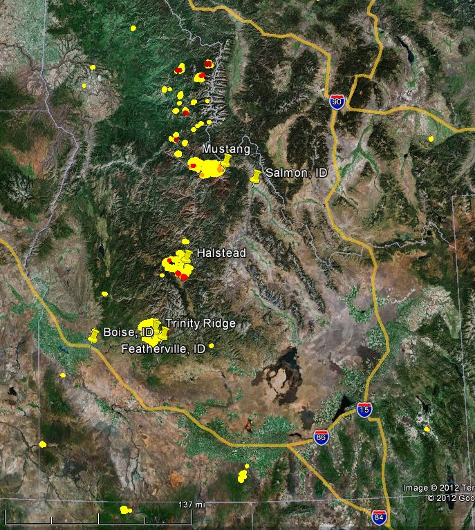
Central Idaho contains some of the most remote land in the lower 48 states. This area includes the Salmon-Challis National Forest and the massive Frank Church-River of No Return Wilderness. Because these areas are heavily forested and characterized by steep, inaccessible terrain, fires here are common and often allowed to burn for ecological benefits unless they threaten structures. Tourists heading to Stanley or Redfish Lake should be particularly aware of central fires, as smoke tends to settle in the valleys, potentially obscuring the iconic views of the Sawtooth Mountains.
The Northern Panhandle and Heavy Timber
The northern part of the state, home to Coeur d’Alene and Sandpoint, is known for its dense, moist forests. While this region typically has a shorter fire season than the south, the Idaho Panhandle National Forests can experience significant “stand-replacing” fires during drought years. These fires can impact major travel corridors like Interstate 90 and can affect water-based recreation on Lake Coeur d’Alene or Lake Pend Oreille due to thick smoke and firefighting aircraft using the lakes to scoop water.
The Southern High Desert and Sagebrush Steppe
In southern Idaho, near Boise and Twin Falls, the landscape shifts toward sagebrush and grasslands managed by the Bureau of Land Management. Fires here move much faster than timber fires. While they may not last as long as a mountain fire, they can rapidly affect visibility on highways and threaten recreational areas like Craters of the Moon National Monument. The Boise National Forest, located just north of the capital, is a frequent site for lightning-sparked fires that can affect the popular Payette River rafting routes.
Tourism Impacts: How to Plan Around Fire Season
Planning a trip to Idaho during the summer requires a degree of flexibility. While most fires do not result in total evacuations of tourist towns, they can significantly alter the “vibe” and safety of your activities.
Monitoring Air Quality
Perhaps the most widespread impact of forest fires on tourism is smoke. Even if a fire is 100 miles away in Oregon or Washington, prevailing winds can carry thick haze into Idaho valleys. For tourists, this means that the spectacular views of the Bitterroot Range might be replaced by a gray wall. More importantly, high levels of particulate matter can make strenuous hiking or biking dangerous, especially for children or the elderly. Tools like AirNow provide real-time updates that are essential for planning daily outings in places like McCall or Sun Valley.
Trail and Road Closures
When a fire is active, the United States Forest Service may issue emergency area closures. This can be frustrating for those who have spent months planning a thru-hike on the Idaho Centennial Trail. Before heading to a trailhead, it is vital to check local ranger station reports. Roads like Highway 21, which connects Boise to the Sawtooth Valley, are frequently subject to temporary closures or “pilot car” escorts if a fire is burning near the shoulder.

Water-Based Recreation and Fishing
Fire season often coincides with the best fly-fishing months on the South Fork of the Snake River or the Kelly Creek area. While fires rarely “close” a river, ash fallout can temporarily change water chemistry or visibility. Furthermore, if a fire is nearby, the Idaho Department of Fish and Game may restrict access to certain boat ramps to allow for emergency operations. If you are booked with an outfitter in Riggins for a Salmon River trip, stay in close contact with them; these professionals are experts at navigating fire-related logistical shifts.
Responsible Tourism: Preventing the Next Spark
Tourism is a vital part of the Idaho economy, but it also brings increased risk. A significant percentage of wildfires in the state are human-caused. Being a responsible tourist means adhering to strict fire safety protocols to protect the very landscapes you have come to enjoy.
Fire Restrictions and Campfire Bans
As the summer progresses, the Idaho Department of Lands often implements “Stage 1” or “Stage 2” fire restrictions.
- Stage 1: This usually limits campfires to established fire rings in developed campgrounds.
- Stage 2: This is much stricter, often banning campfires entirely, as well as smoking outdoors or operating internal combustion engines (like chainsaws or ATVs) during certain hours.
Disregarding these rules isn’t just a safety hazard; it carries heavy fines and potential legal liability for the cost of fire suppression.
Vehicle and Equipment Safety
Many visitors explore Idaho via RV or by towing trailers to spots like Yellowstone National Park (which borders eastern Idaho). Dragging safety chains on the pavement can create sparks that ignite dry roadside grass. Similarly, parking a hot vehicle over tall, dry grass in a dispersed camping spot in the Payette National Forest can start a fire in seconds. Always stay on designated roads and check your equipment frequently.
The “Leave No Trace” Philosophy in Fire Season
The principles of Leave No Trace are amplified during fire season. This includes properly disposing of cigarette butts and being extremely cautious with portable stoves. In the Nez Perce-Clearwater National Forests, where the terrain is dense and the fuel loads are high, even a small mistake can lead to a massive conflagration.
Essential Resources for Travelers
If you are currently in Idaho or planning a visit, several real-time resources can help you stay informed about fire locations and safety.
Using InciWeb
InciWeb is the official interagency system for tracking wildfires across the country. By filtering for Idaho, you can see a map of all active fires, read daily updates from Incident Commanders, and view maps of the fire’s growth. This is the most reliable source for knowing if a fire is moving toward a town like Ketchum or if a specific park like Hells Canyon is affected.
Local Visitor Bureaus
The tourism offices in towns like Lewiston or Idaho Falls are excellent resources. They often have the most up-to-date information on how local fires are affecting tourism services, such as hotel availability (which can be squeezed when firefighters move into town) or local festival cancellations.
The National Interagency Fire Center
Based in Boise, the National Interagency Fire Center (NIFC) is the nation’s logistical heart for wildfire response. While it isn’t a “tourist site” in the traditional sense, their reports provide a high-level overview of the fire season’s severity across the Western United States. Monitoring their national outlook can help you decide if a late-August trip to North America’s mountain regions is the right move for your group.
Wildfire is a natural part of the Idaho landscape, a force that rejuvenates the soil and creates new habitats. By staying informed, remaining flexible, and practicing responsible recreation, tourists can safely enjoy everything the state has to offer while respecting the power of the forest fires that shape it. Whether you are gazing at the Lochsa River or exploring the heights of Mount Borah, being “fire-aware” is the hallmark of a savvy and respectful traveler.
LifeOutOfTheBox is a participant in the Amazon Services LLC Associates Program, an affiliate advertising program designed to provide a means for sites to earn advertising fees by advertising and linking to Amazon.com. Amazon, the Amazon logo, AmazonSupply, and the AmazonSupply logo are trademarks of Amazon.com, Inc. or its affiliates. As an Amazon Associate we earn affiliate commissions from qualifying purchases.