
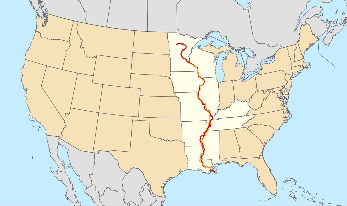
The Mississippi River, a colossal artery of the North American continent, is an iconic natural landmark whose presence has shaped the history, economy, and geography of the United States. Its sheer scale and significance make it a focal point for understanding the nation’s internal landscape. To pinpoint its location on a map is to grasp the vastness of the American heartland, from its northern origins to its southern delta.
The River’s Extensive Reach: From Headwaters to Gulf
The Mississippi River is the second-longest river in North America, surpassed only by its tributary, the Missouri River. Its drainage basin, however, is the fourth largest in the world, encompassing all or parts of 32 U.S. states and two Canadian provinces. This immense watershed underscores the river’s fundamental role in the continent’s hydrological system.
Originating in the North: Lake Itasca and Minnesota
The journey of the Mississippi River begins in the northern reaches of the United States, specifically in the state of Minnesota. Its official source is Lake Itasca, a small, picturesque lake nestled within the Itasca State Park. Here, at an elevation of approximately 1,475 feet (450 meters) above sea level, the river emerges as a humble, shallow stream, a stark contrast to its mighty stature downstream. Visitors can famously walk across the river at its headwaters, a symbolic step into the river’s immense journey.
The Great Plains and the Central United States
As the Mississippi River flows southward, it carves its path through the vast and fertile plains of the Midwest. It forms the eastern border of states like Minnesota, Wisconsin, Iowa, and Missouri, and the western border of Illinois, Kentucky, and Tennessee. This stretch is crucial for agriculture, with the river providing water for crops and serving as a vital transportation route for goods.
Navigating the Lower Mississippi: Towards the Delta
Further south, the river becomes significantly wider and more powerful. It forms the western border of Arkansas and Mississippi, and then the eastern border of Louisiana. This region is characterized by its lush landscapes, bayous, and a humid subtropical climate. It is here that the river’s historical significance is perhaps most palpable, with numerous port cities and cultural hubs dotting its banks.
The Final Destination: The Gulf of Mexico
The ultimate endpoint of the Mississippi River is the Gulf of Mexico, where it empties through a sprawling deltaic complex in southern Louisiana. This delta, a testament to the river’s sediment-carrying power, is a unique and ecologically rich environment. The river’s mouth is a critical point for global trade, as it connects the American interior to international waterways.
Key States and Cities Along the Mississippi
Understanding the Mississippi River’s location involves recognizing the states and prominent cities that lie along its course. Each location offers a unique perspective on the river’s influence.
The Upper Mississippi: From Headwaters to St. Louis
The upper section of the river, from Lake Itasca to the confluence with the Ohio River near St. Louis, is often characterized by its natural beauty and historical significance.
- Minneapolis–Saint Paul, Minnesota: Known as the “Twin Cities,” these metropolitan areas are major economic and cultural centers situated on the Mississippi River.
- Galesburg, Illinois: While not directly on the river, its proximity to the Mississippi River has historically linked it to river trade and transportation.
- Davenport, Iowa; Rock Island, Illinois; Bettendorf, Iowa; and Moline, Illinois: These four cities, collectively known as the “Quad Cities,” form a significant urban area along the river, straddling the border between Iowa and Illinois.
- Dubuque, Iowa: A historic river port city in Iowa, known for its steep hills and vibrant riverfront.
- La Crosse, Wisconsin: Situated in a scenic region where the river widens, La Crosse is a popular destination for outdoor recreation.
- Hannibal, Missouri: Famously known as the boyhood home of author Mark Twain, whose writings often captured the spirit of life on the Mississippi River.
The Middle Mississippi: St. Louis to the Ohio River Confluence

This section of the river is characterized by its increasing width and the confluence with major tributaries.
- St. Louis, Missouri: Home to the iconic Gateway Arch, St. Louis is a major metropolitan area situated at the confluence of the Mississippi River and the Missouri River. The Missouri River joins the Mississippi River just north of the city, significantly increasing the latter’s volume.
The Lower Mississippi: From the Ohio River to the Gulf
This is the most voluminous and widest part of the river, flowing through the southern United States.
- Memphis, Tennessee: A major port city and cultural hub, Memphis is renowned for its music heritage and its significant role in the nation’s logistics.
- Vicksburg, Mississippi: A city with a rich Civil War history, Vicksburg sits atop bluffs overlooking the river, offering strategic views.
- Baton Rouge, Louisiana: The capital of Louisiana, Baton Rouge is an important industrial and petrochemical center on the river.
- New Orleans, Louisiana: Perhaps the most famous city on the Mississippi River, New Orleans is a global destination known for its unique culture, cuisine, and lively atmosphere. It lies just upstream of the river’s delta.
Mapping the Mississippi: A Geographic Perspective
From a cartographic standpoint, the Mississippi River is a defining feature of any map of the United States. Its sinuous path can be traced across numerous states, acting as a natural boundary and a central artery.
The Continental Divide and Drainage Basins
The Mississippi River system is a significant part of the North American continent’s drainage system. Its watershed is vast, encompassing drainage from the Rocky Mountains in the west to the Appalachian Mountains in the east. Understanding its location on a map is also understanding the flow of water across a massive portion of the continent.
Navigational Importance and Cartographic Representation
Historically, the Mississippi River has been a crucial waterway for exploration, settlement, and commerce. Maps have long depicted its course, with its navigability and the locations of its ports and cities being of paramount importance. Modern maps show its detailed path, including dams, locks, and major bridges that facilitate passage and control its flow. The river’s changing course over centuries is also a subject of historical cartography, illustrating its dynamic nature.
The Mississippi River Basin: A Vast Ecological and Economic Zone
The region surrounding the Mississippi River, known as the Mississippi River Basin, is an area of immense ecological diversity and economic activity. Its location on a map defines a significant portion of the American landscape.
Ecological Significance of the Delta Region
The Mississippi River Delta is a globally important wetland ecosystem, providing habitat for countless species of birds, fish, and other wildlife. It is also a vital area for buffering coastal communities from storm surges. Its location at the river’s mouth, facing the Gulf of Mexico, makes it a unique geographical and environmental zone.

Economic Powerhouse: Agriculture and Transportation
The fertile floodplains of the Mississippi River support some of the most productive agricultural land in the world. The river itself is a superhighway for barges, transporting commodities like grain, coal, and petroleum. Mapping the river is thus also mapping a critical component of the U.S. economy. The major ports along its course, from Minneapolis to New Orleans, are vital nodes in this economic network.
In essence, locating the Mississippi River on a map is not merely an exercise in geography; it is an invitation to explore the heart of America, a region defined by its monumental natural landmark and the vibrant tapestry of life and commerce it supports.
LifeOutOfTheBox is a participant in the Amazon Services LLC Associates Program, an affiliate advertising program designed to provide a means for sites to earn advertising fees by advertising and linking to Amazon.com. Amazon, the Amazon logo, AmazonSupply, and the AmazonSupply logo are trademarks of Amazon.com, Inc. or its affiliates. As an Amazon Associate we earn affiliate commissions from qualifying purchases.