
The question of New Orleans’ elevation is not merely an academic one; it is intrinsically linked to the very identity and resilience of this vibrant, culturally rich American city. Nestled on the Mississippi River delta, New Orleans occupies a unique and often precarious geographical position. Understanding its elevation is key to appreciating its history, its architectural ingenuity, and the ongoing challenges and triumphs of its inhabitants. This exploration delves into the precise elevations of New Orleans, the geological factors that shape them, and how this fundamental characteristic influences life in the Crescent City.
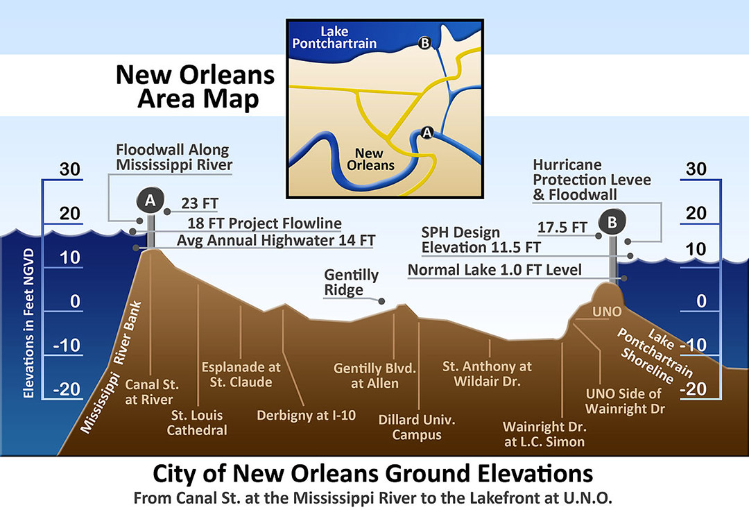
The Geological Foundation: A City Below Sea Level
New Orleans is renowned for its unique geography, a characteristic that profoundly impacts its elevation. The city is situated on the Mississippi River delta, a region formed by millennia of sediment deposition. This process, while creating fertile land, also results in soils that are inherently unstable and prone to subsidence.
Understanding Land Subsidence
One of the most critical factors influencing New Orleans’ elevation is land subsidence. This is the sinking of the land surface relative to sea level. In New Orleans, subsidence is driven by a complex interplay of natural and human-induced causes. Naturally, the consolidation of the deltaic sediments, the compaction of organic material, and the withdrawal of groundwater all contribute to the land sinking over time. The Mississippi River, once a natural builder of the delta, has also been heavily engineered with levees and dams, reducing the natural replenishment of sediment that historically counteracted subsidence. The consequence is a significant portion of the city is now below sea level, a fact that shapes its infrastructure and vulnerability.
The Role of Coastal Wetlands
The surrounding coastal wetlands, particularly the Louisiana marshes, play a vital role in the city’s elevation and protection. These wetlands act as natural sponges, absorbing storm surges and reducing the impact of hurricanes. However, these wetlands are themselves shrinking due to a combination of factors, including sea-level rise, canal dredging, and coastal erosion. The loss of this natural buffer exacerbates the vulnerability of New Orleans, making its below-sea-level elevation an even more pressing concern.
The Average Elevation: A Closer Look at Ground Level
When discussing the elevation of New Orleans, it’s important to understand that it’s not a uniform landscape. The city’s topography varies significantly, with different neighborhoods experiencing different levels of risk and requiring different adaptations.

The Lowest Points and Highest Ground
The average elevation of New Orleans is often cited as around 6 feet (1.8 meters) below sea level in many areas. However, this is a generalization. The lowest points in the city can be found in areas like the West Bank and portions of the Lower Ninth Ward, where elevations can dip as low as 10 feet (3 meters) below sea level. Conversely, some areas, particularly those in older, more established neighborhoods like parts of the French Quarter and Uptown, are situated on natural levees or higher ground, offering slightly more elevated positions. These higher areas, while still vulnerable, historically provided a marginal advantage during flood events. The city’s development has historically followed these slightly higher natural formations.
The Impact of Drainage Systems
Given that much of New Orleans lies below sea level, the city’s sophisticated drainage system is a marvel of engineering and a testament to its determination to thrive. A network of canals, pumps, and floodgates works continuously to remove water and prevent the city from inundating. This system is crucial for maintaining the habitable conditions of the city, especially during heavy rainfall or when facing tidal influences. The effectiveness of these systems is directly tied to the elevation of the land they are designed to protect.
Living Below Sea Level: Challenges and Adaptations
The reality of living in a city with large portions below sea level presents a unique set of challenges that have shaped its architecture, infrastructure, and the very lifestyle of its residents.
Architectural Innovations and Building Practices
New Orleans’ unique elevation has necessitated innovative architectural solutions. Traditional Creole cottages, for instance, are often built on stilts or raised foundations to mitigate the risk of flooding. Newer construction also adheres to stringent building codes that require elevated foundations. The concept of “raised architecture” is not merely a stylistic choice but a fundamental necessity for survival and long-term habitation in this environment. This adaptation is evident in everything from single-family homes to commercial buildings and essential infrastructure.

The Specter of Flooding and Resilience
The most significant challenge associated with New Orleans’ elevation is its vulnerability to flooding, particularly from hurricanes and heavy rainfall. The catastrophic events of Hurricane Katrina in 2005 served as a stark reminder of these risks, with widespread levee failures leading to devastating inundation. In response, significant investments have been made in reinforcing and expanding the city’s levee system and flood defenses. The resilience of the New Orleans community, however, extends beyond infrastructure; it is a spirit of determination and adaptation that has allowed the city to rebuild and continue to thrive despite its geographical challenges. This ongoing commitment to preparedness and adaptation is a defining characteristic of life in the Crescent City.
LifeOutOfTheBox is a participant in the Amazon Services LLC Associates Program, an affiliate advertising program designed to provide a means for sites to earn advertising fees by advertising and linking to Amazon.com. Amazon, the Amazon logo, AmazonSupply, and the AmazonSupply logo are trademarks of Amazon.com, Inc. or its affiliates. As an Amazon Associate we earn affiliate commissions from qualifying purchases.