
New York, a name synonymous with ambition, culture, and an undeniable energy, holds a prominent place not just in the global consciousness but also on the world map. For many, it is an abstract concept, a vibrant tapestry woven from films, literature, and dreams. But for those planning a visit or simply curious about its geographical standing, understanding precisely where New York resides is the foundational step in appreciating its scale and significance. This exploration will pinpoint New York’s location, delve into its various facets as a geographical entity, and highlight its interconnectedness with the wider world.

The Empire State: A Geographical Overview
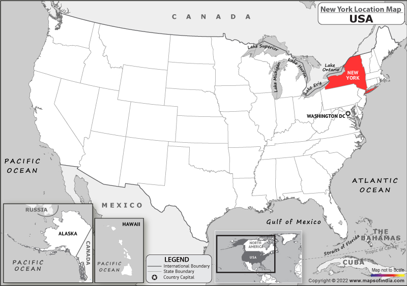
At its core, “New York” refers to a state within the United States of America. It is situated in the northeastern region of the country, often categorized as part of the Mid-Atlantic or Northeastern states. Its strategic location has played a pivotal role in its historical development and ongoing economic prowess.
Borders and Neighbors
The state of New York shares its borders with several other states and even an international boundary.
Eastern and Southern Frontiers
To its east, New York is bordered by Vermont and Massachusetts. Further south along its eastern seaboard, it meets Connecticut. The southern border is shared with two other states: New Jersey to the southwest and Pennsylvania to the south. These bordering states contribute to the diverse cultural and economic landscape of the region, fostering trade and interaction.
Northern Exposure
The northern frontier of New York is marked by a significant international boundary: the St. Lawrence River and Lake Ontario separate it from Canada, specifically the provinces of Ontario and Quebec. This proximity to Canada has historically influenced trade, migration, and cultural exchange, making New York a crucial gateway to and from its northern neighbor.
Western Shores
To the west, New York’s border is defined by Lake Erie and a portion of Lake Ontario. These Great Lakes not only form a natural boundary but also serve as vital waterways for commerce and recreation.
Inland Geography
Beyond its borders, New York possesses a varied and dynamic interior geography.
Appalachian Influence
A significant portion of New York is covered by the Appalachian Mountains, particularly the Catskill Mountains in the southeast and the Adirondack Mountains in the north. The Adirondacks, a vast wilderness area, are renowned for their rugged beauty, numerous lakes, and hiking trails, offering a stark contrast to the urban intensity of the state’s most famous city.
Waterways and Lakes
New York is rich in water resources. The Hudson River is arguably the most famous, flowing from the Adirondacks southward through the state before emptying into the Atlantic Ocean. It is a critical transportation artery and a historical landmark. Beyond the Great Lakes, the state is dotted with countless smaller lakes, including the renowned Finger Lakes region in the west, known for its wineries and picturesque scenery. The Erie Canal, a historic engineering marvel, bisects the state, connecting the Great Lakes to the Hudson River and the Atlantic, thus playing a crucial role in the nation’s development.
The Jewel in the Crown: New York City
While the state of New York is geographically diverse, the name “New York” most commonly conjures images of New York City, a global metropolis located at the mouth of the Hudson River where it meets the Atlantic Ocean. It is the most populous city in the United States and a leading center of international finance, culture, fashion, and diplomacy.
A Southern Tip Location
New York City is situated in the southeastern corner of New York State. It comprises five boroughs: Manhattan, Brooklyn, Queens, the Bronx, and Staten Island. These boroughs are strategically positioned to take advantage of the natural harbor and the confluence of rivers.
Manhattan: The Island Heart
Manhattan, the most iconic of the boroughs, is an island situated between the Hudson River to the west and the East River to the east, with the Harlem River forming its northern boundary, separating it from the Bronx. Its dense urban landscape is world-renowned, home to landmarks like the Empire State Building, Times Square, and Central Park.
Brooklyn and Queens: East River Shores
Brooklyn and Queens are located on Long Island, east of Manhattan, separated by the East River. They form the most populous parts of the city and are connected to Manhattan by numerous bridges and tunnels. Long Island itself is a peninsula that extends eastward into the Atlantic Ocean.
The Bronx: Northern Reach
The Bronx is the only part of New York City that is located on the mainland of North America, north of Manhattan. It shares borders with Westchester County to the north and the Long Island Sound to the east.
Staten Island: The Southern Expanse
Staten Island is an island borough located in the western part of New York Harbor, south of Manhattan and west of Brooklyn. It is separated from New Jersey by the Arthur Kill and the Kill Van Kull.
Global Connectivity
New York City’s position at the mouth of the Hudson River and its access to the Atlantic Ocean have historically made it a major port of entry for immigrants and a hub for international trade. This strategic location continues to facilitate its role as a global city, with major international airports like John F. Kennedy International Airport (JFK) and Newark Liberty International Airport (EWR, located in nearby New Jersey but serving the New York metropolitan area) connecting it to virtually every corner of the globe.
Understanding “New York” in Context
When discussing “New York,” it is crucial to differentiate between New York State and New York City. While the city is undeniably the most famous entity associated with the name, the state encompasses a much larger and more diverse geographical area.
State vs. City: A Crucial Distinction
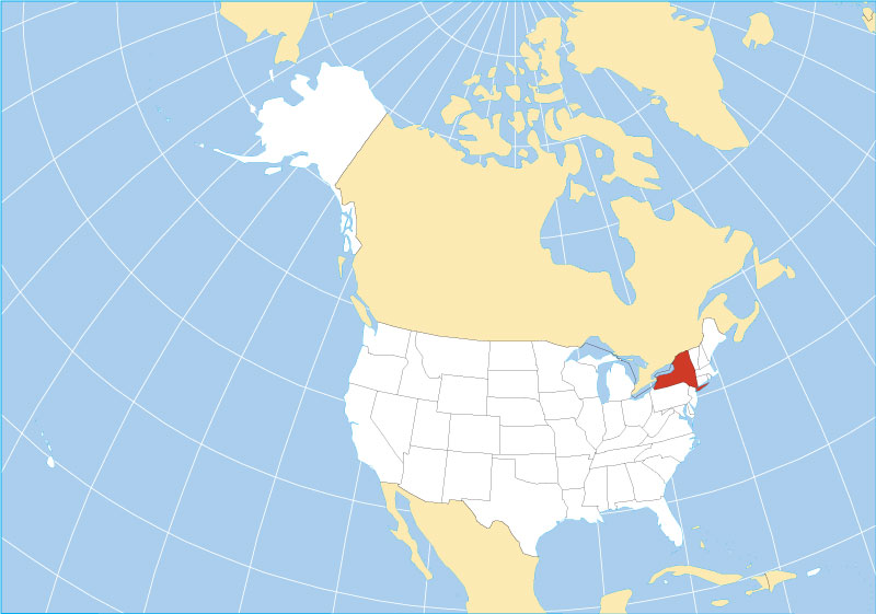
On a map, New York State covers a significant area stretching from the Great Lakes in the west to the Atlantic Ocean in the southeast. New York City occupies a relatively small but densely populated portion of this state, specifically in its southeastern corner. Recognizing this distinction is key to understanding the scale of both the state’s natural beauty and the city’s urban density.
Navigating the Map of New York
To locate New York on a world map, one would first identify the United States of America. Within the US, look to the northeast. You will find New York State positioned between the Atlantic Ocean, the Great Lakes, and Canada. Zooming into the southeastern tip of the state reveals the sprawling urban landscape of New York City. The Hudson River serves as a vital landmark, flowing through the state and its most famous city.
A Hub of Global Activity
New York’s geographical placement—bordered by major waterways, inland mountains, and an international neighbor—has fostered a unique blend of natural resources and human ingenuity. From the agricultural richness of its upstate regions to the financial dynamism of Wall Street in Manhattan, New York’s location underpins its multifaceted identity. It is a state and a city that have consistently leveraged their geographical advantages to become central players on the national and international stage. Understanding where New York is on a map is not just about coordinates; it is about grasping the foundation of its power, its allure, and its enduring significance in the modern world.
LifeOutOfTheBox is a participant in the Amazon Services LLC Associates Program, an affiliate advertising program designed to provide a means for sites to earn advertising fees by advertising and linking to Amazon.com. Amazon, the Amazon logo, AmazonSupply, and the AmazonSupply logo are trademarks of Amazon.com, Inc. or its affiliates. As an Amazon Associate we earn affiliate commissions from qualifying purchases.