
Texas, a state synonymous with vast landscapes, rich history, and a distinct cultural identity, occupies a significant geographical position within the United States. Its location is not merely a point on a map; it’s a strategic crossroads that has profoundly shaped its development and continues to influence its role in the nation’s economy and culture. Understanding where Texas is situated is key to appreciating its unique character, from its diverse terrains to its historical significance as a gateway to the American Southwest.
Strategic Position in the South Central United States
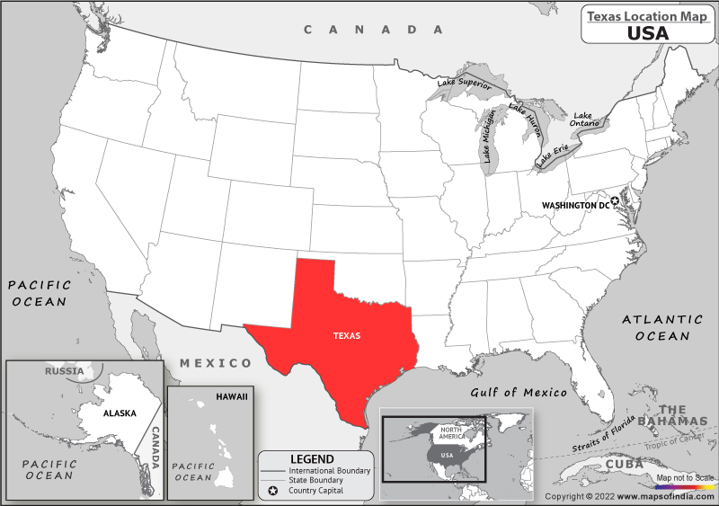
Texas is primarily located in the South Central region of the United States, bordering Mexico to the south and southwest. This extensive southern border, defined largely by the Rio Grande River, has historically been a crucial factor in Texas‘s development, influencing its demographics, economy, and political landscape. The state’s proximity to Mexico has fostered a vibrant cultural exchange and continues to be a focal point for international trade and relations.
Bordering States and Regional Significance
To the east, Texas shares borders with Louisiana and Arkansas. To the north, it is bordered by Oklahoma. To the west, New Mexico lies to its west, and a small portion of Colorado touches its northwestern corner. This complex network of borders places Texas at the nexus of several distinct regional influences, drawing elements from the Deep South, the Southwest, and the Great Plains. This unique positioning has contributed to Texas‘s diverse population, a mosaic of cultures and traditions that have blended over centuries.
The Significance of the Gulf Coast
A substantial portion of Texas‘s southern border is defined by its coastline along the Gulf of Mexico. This extensive shoreline, stretching over 367 miles (589 km), provides the state with vital ports, such as Port of Houston and Port of Corpus Christi, which are instrumental in international trade and commerce. The Gulf Coast also supports significant industries, including fishing, tourism, and petrochemicals, making it a critical economic engine for the state. The climate along the Gulf Coast is characterized by humid subtropical weather, supporting lush vegetation and distinct ecosystems.
Topographical Diversity and Regional Divisions
Beyond its political boundaries, Texas is a state of immense topographical diversity, often divided into several distinct regions, each with its own unique characteristics. This diversity is a direct consequence of its extensive landmass and its varied geographical influences.
The Piney Woods and East Texas
In the eastern part of the state lies the Piney Woods, a region characterized by dense forests of pine and hardwood trees, rolling hills, and abundant rainfall. This area, often considered part of the Deep South, offers a stark contrast to the arid landscapes found elsewhere in Texas. It’s a region rich in natural beauty, with state parks and forests providing opportunities for outdoor recreation. Historically, this region was vital for timber production and agriculture.
The Blackland Prairies and Central Texas
Stretching from the north to the south in the central part of the state are the Blackland Prairies. This fertile region is renowned for its rich, dark soil, making it a prime agricultural area, particularly for cotton and corn. Central Texas, encompassing major cities like Austin, San Antonio, and Waco, is the heart of the state’s cultural and political activity. It’s a region of rolling hills, live oak trees, and a vibrant arts and music scene, shaped by a blend of Southern charm and Southwestern spirit.
The Edwards Plateau and the Hill Country
West of the Blackland Prairies lies the Edwards Plateau, more commonly known as the Texas Hill Country. This region is characterized by its rugged hills, clear streams, and natural springs, offering a picturesque landscape that attracts tourists and residents alike. The Hill Country is famous for its wineries, German heritage in towns like Fredericksburg, and its unique flora and fauna, including the endangered Golden-cheeked Warbler.
The Trans-Pecos and West Texas

To the west, Texas transitions into the arid landscapes of the Trans-Pecos region. This vast expanse is dominated by mountains, deserts, and high plains, forming part of the larger Chihuahuan Desert ecosystem. It’s here that one finds Big Bend National Park, a jewel of natural beauty and wilderness. The Trans-Pecos is also home to significant oil and gas reserves, which have played a crucial role in the state’s economy. The elevation in this region can be quite high, leading to cooler temperatures in some areas compared to the coast.
The Panhandle and North Texas
The northernmost part of Texas is the Panhandle, a flat, elevated plain that forms the top of the state’s distinctive panhandle shape. This region is known for its agricultural productivity, particularly for cattle ranching and grain farming. It also contains the Palo Duro Canyon, the second-largest canyon in the United States. North Texas, centered around the Dallas-Fort Worth metroplex, is a major hub for commerce, transportation, and culture, representing a modern and dynamic facet of Texas.
Historical Context and Geographic Influence
The location of Texas has been central to its storied history, from its time as part of New Spain and Mexico to its status as an independent republic and, finally, as a state within the United States. Its position allowed it to be a buffer zone, a territory of conflict, and a land of opportunity.
From Republic to Statehood
Texas‘s journey to statehood was deeply intertwined with its geography. The desire for independence from Mexico was fueled, in part, by the vast distances and differing governance styles. After achieving independence and forming the Republic of Texas, its strategic location on the border of the United States and Mexico made its annexation a complex and contentious issue, ultimately leading to the Mexican-American War. As a state, Texas continued to serve as a westward expansion frontier, a vital corridor for settlers moving into the Southwest.
Economic Powerhouse and Transportation Hub
Texas‘s expansive territory and its location at the crossroads of the nation have made it a critical hub for transportation and commerce. Major interstate highways crisscross the state, connecting it to all corners of the United States and Mexico. Its numerous airports, including Dallas/Fort Worth International Airport and George Bush Intercontinental Airport in Houston, handle immense passenger and cargo traffic. Furthermore, its extensive network of railroads and its vital ports on the Gulf of Mexico solidify its position as an economic powerhouse. The discovery of vast oil reserves, particularly in the Permian Basin and along the Gulf Coast, has dramatically amplified its economic significance, further cementing its place as a major energy producer for the nation.
Climate Variations Across the State
The sheer size of Texas results in significant climatic variations, from the humid subtropics of the Gulf Coast to the arid conditions of the west. Understanding these variations is crucial for appreciating the state’s diverse ecosystems and its agricultural potential.
Humid Subtropical East and Central Texas
The eastern and central parts of Texas, including the Piney Woods, Blackland Prairies, and much of the Hill Country, experience a humid subtropical climate. This means hot, humid summers and mild winters, with abundant rainfall distributed throughout the year. This climate is ideal for agriculture and supports dense vegetation. Cities like Houston, Dallas, and San Antonio fall within this climatic zone.
Semi-Arid West Texas and Panhandle
As one moves westward, the climate becomes increasingly semi-arid and arid. The Trans-Pecos region and the Panhandle receive significantly less rainfall and experience greater temperature extremes. Summers can be intensely hot, while winters can be cold, especially in the northern Panhandle. The Chihuahuan Desert ecosystem is a hallmark of this drier climate, supporting drought-resistant plants and unique wildlife.
Coastal Climate and Hurricane Risk
The Texas Coast along the Gulf of Mexico has a distinct maritime climate, characterized by high humidity, warm temperatures year-round, and a higher frequency of tropical storms and hurricanes. This coastal environment fosters unique ecosystems, such as marshes and bayous, and is a significant draw for tourism, but it also presents a recurring natural hazard that residents and authorities must continually manage.
In conclusion, Texas‘s location is not just a geographical fact but a fundamental element that has sculpted its identity, shaped its history, and continues to define its present and future. From its strategic southern border with Mexico and its vital Gulf Coast access to its diverse interior landscapes and its position as a pivotal state within the United States, Texas remains a unique and influential entity, a true microcosm of the American experience.
LifeOutOfTheBox is a participant in the Amazon Services LLC Associates Program, an affiliate advertising program designed to provide a means for sites to earn advertising fees by advertising and linking to Amazon.com. Amazon, the Amazon logo, AmazonSupply, and the AmazonSupply logo are trademarks of Amazon.com, Inc. or its affiliates. As an Amazon Associate we earn affiliate commissions from qualifying purchases.