
The vast and varied landscapes of the American West invite exploration, and for many, the question of proximity between two iconic states, Arizona and Colorado, is a key consideration for planning an unforgettable journey. These neighboring states, though sharing a border in the Four Corners region, offer vastly different experiences, from the sun-baked deserts of the Sonoran Desert to the towering peaks of the Rocky Mountains. Understanding the distances involved is crucial for crafting road trips, choosing between air travel, or simply appreciating the geographical relationship between these natural wonders.
Mapping the Miles: Direct and Indirect Routes
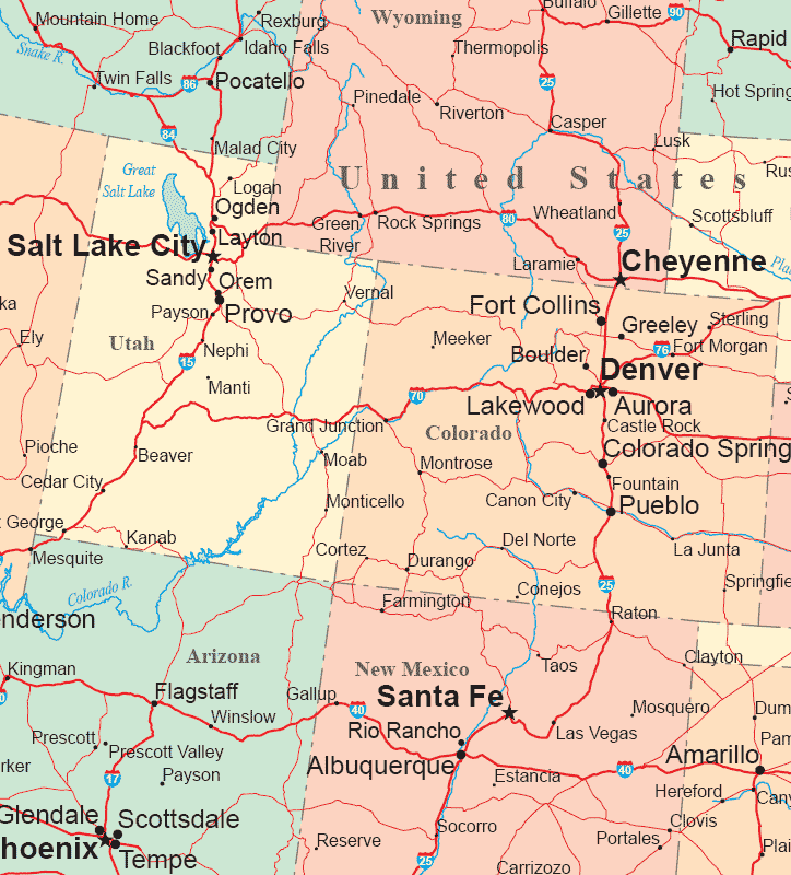
The most direct routes between Arizona and Colorado primarily involve navigating through shared border areas or traversing through key cities within each state. The exact mileage can fluctuate based on your starting point and final destination. For instance, the distance between the northernmost point of Arizona near the Four Corners Monument and the southernmost point of Colorado in Durango is relatively short, covering a mere fifty miles or so. However, this is a simplified view, as most travel plans involve reaching major population centers or iconic attractions.
Driving Distances: Key City Pairings
When planning a road trip, specific city pairings offer a clearer picture of the driving time and distance.
- Phoenix, Arizona to Denver, Colorado: This is a popular route for many travelers. The most common driving path utilizes major interstates like I-17 North from Phoenix to Flagstaff, followed by I-40 East to Albuquerque, New Mexico, and then I-25 North to Denver. This journey typically spans approximately 800 miles and can take anywhere from 12 to 14 hours of pure driving time, not accounting for stops, traffic, or potential weather delays, especially during winter months when mountain passes can be affected.
- Tucson, Arizona to Colorado Springs, Colorado: Another common pairing, this route often follows a similar pattern, heading north from Tucson towards Flagstaff or other connecting routes to New Mexico. The distance is comparable, around 750-800 miles, with a similar driving duration of 12-13 hours.
- Northern Arizona (e.g., Flagstaff) to Southern Colorado (e.g., Durango): For those focusing on the border region and its natural attractions like the Grand Canyon or Mesa Verde National Park, the distances are considerably shorter. Driving from Flagstaff to Durango involves heading north on US-89 and then east on various state highways, covering approximately 300-350 miles and taking about 5-6 hours of driving.
It’s essential to consult real-time navigation apps for the most accurate mileage and estimated travel times based on your exact starting and ending points, as well as current road conditions.
The Influence of Terrain and Border Crossings
The direct line between Arizona and Colorado is not a straight, unimpeded path. The ruggedness of the Colorado Plateau and the vastness of the desert landscapes mean that roads often have to weave around geographical obstacles. Furthermore, the most practical and efficient driving routes frequently involve traversing a portion of New Mexico. This detour, while adding miles, often utilizes better-maintained highways and offers a more direct connection to major interstates.
Air Travel: Bridging the Gap Swiftly
For travelers seeking to minimize transit time, air travel offers a significant advantage. The vast distances that require a full day of driving can be covered in a matter of hours by plane.
Major Airport Hubs and Flight Routes
Both Arizona and Colorado boast major international airports that serve as gateways for travelers.
- Phoenix Sky Harbor International Airport (PHX) in Phoenix, Arizona: As one of the busiest airports in the American Southwest, PHX offers numerous direct and connecting flights to major Colorado airports.
- Denver International Airport (DEN) in Denver, Colorado: This expansive hub is a primary gateway to the Rocky Mountain region and serves a vast array of domestic and international flights.
Other notable airports in Arizona include Tucson International Airport (TUS) and Phoenix-Mesa Gateway Airport (AZA). In Colorado, secondary airports such as Colorado Springs Airport (COS) and Eagle County Regional Airport (EGE) near Vail also facilitate travel, though direct routes from Arizona might be less frequent.

Flight Durations and Connecting Options
A direct flight from Phoenix to Denver typically lasts between 1.5 to 2 hours. Flights from Tucson to Denver are slightly longer, around 2 hours. While direct flights are the most efficient, connecting flights through hubs like Salt Lake City or Las Vegas can sometimes offer more affordable options, though they will naturally extend the overall travel time.
When booking flights, it’s advisable to compare prices and schedules across different airlines and consider the total travel time, including airport security, boarding, and potential layovers. The ease of air travel makes a weekend getaway or a longer vacation bridging the distinct environments of Arizona and Colorado a highly feasible prospect.
Factors Influencing Travel Time and Experience
Beyond raw mileage, several factors significantly influence the travel experience between Arizona and Colorado. These include the time of year, the chosen mode of transport, and the specific destinations within each state.
Seasonal Considerations and Road Conditions
The starkly different climates of Arizona and Colorado mean that seasonal conditions play a critical role in travel planning.
- Summer (June-August): This is a popular time for road trips, with generally clear roads. However, Arizona can experience extreme heat, especially in desert regions, while Colorado offers pleasant temperatures for outdoor activities in its mountainous areas. Monsoons can bring heavy rain and flash floods to parts of Arizona during this period.
- Fall (September-November): Autumn brings stunning fall foliage to the higher elevations of Colorado, making it an ideal time for scenic drives. Arizona experiences milder temperatures, perfect for exploring its national parks.
- Winter (December-February): This is prime ski season in Colorado, but snow can cause significant delays and road closures, particularly on mountain passes. Arizona, while still having cold temperatures in its northern regions, remains largely accessible, though snow can impact areas around Flagstaff and the Grand Canyon.
- Spring (March-May): Spring can be unpredictable. While Arizona begins to warm up, Colorado can still experience significant snowfall, especially in the mountains. Mud season can also be a factor in Colorado.
Always check weather forecasts and road conditions before embarking on your journey, especially if traveling during the winter months or during monsoon season.
Choosing Your Adventure: Road Trip vs. Flying
The choice between driving and flying hinges on your priorities. A road trip offers unparalleled freedom to explore the in-between landscapes, discover roadside attractions, and experience the transition from desert to mountains firsthand. It allows for spontaneous stops at places like Sedona or Moab. However, it demands a significant time commitment.
Flying, on the other hand, prioritizes speed and efficiency. It’s the ideal choice for shorter trips or when maximizing time at your destination is paramount. Upon arrival, you can rent a car to explore the local areas, effectively combining the convenience of air travel with the flexibility of a road trip at your destination.
Destination-Specific Distances
The “how far” question also depends heavily on where in Arizona and Colorado you are headed.
- Southern Arizona to Southern Colorado: Traveling from Yuma to Pueblo, for example, will cover a different distance and take a different amount of time than traveling from Page, Arizona, to Fort Collins, Colorado.
- Iconic Landmarks: Reaching the Grand Canyon National Park from Denver is a different undertaking than reaching Rocky Mountain National Park from Tucson. The former involves a substantial drive of approximately 500-600 miles, taking 8-10 hours, while the latter is a similar distance in reverse.
Ultimately, the distance between Arizona and Colorado is not a static number but a variable that invites careful planning and contributes to the rich tapestry of travel opportunities between these two magnificent Western states.
LifeOutOfTheBox is a participant in the Amazon Services LLC Associates Program, an affiliate advertising program designed to provide a means for sites to earn advertising fees by advertising and linking to Amazon.com. Amazon, the Amazon logo, AmazonSupply, and the AmazonSupply logo are trademarks of Amazon.com, Inc. or its affiliates. As an Amazon Associate we earn affiliate commissions from qualifying purchases.