
California is a dream destination for countless travelers, famous for its diverse landscapes, iconic cities, and unparalleled natural beauty. From the sun-drenched beaches of Southern California to the majestic forests of the north, the Golden State offers an endless array of experiences. However, as climate patterns shift, wildfire season has become an increasingly significant consideration for anyone planning a trip to the region. Understanding where active fires are located and their potential impact is crucial for ensuring a safe, enjoyable, and responsible travel experience.
Understanding California’s Fire Season and Its Impact on Travel
Wildfires are a natural, albeit often devastating, part of California’s ecosystem, particularly during the drier summer and fall months. Factors like prolonged drought, high temperatures, strong winds (such as the Santa Ana and Diablo winds), and an abundance of dry vegetation contribute to the intensity and spread of these blazes. For travelers, an active fire season can introduce a layer of complexity to itinerary planning, impacting everything from route selection to air quality and access to beloved natural attractions.
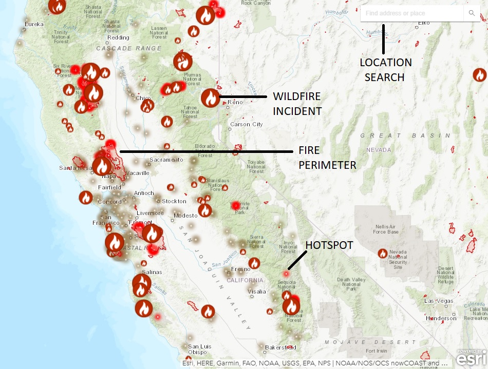
The primary concerns for travelers when fires are active include:
- Road Closures: Major highways and scenic routes, like sections of the Pacific Coast Highway or mountain passes leading to national parks, may be closed for safety reasons or to allow emergency vehicle access. This can lead to significant detours and extended travel times.
- Park and Attraction Closures: National and state parks, forests, and other natural areas are often closed to the public to prevent new ignitions, protect visitors from hazardous conditions, and aid firefighting efforts. This directly impacts outdoor activities such as hiking, camping, and scenic drives.
- Air Quality: Smoke from wildfires can travel hundreds of miles, causing unhealthy air quality levels even in areas far from the active burn zones. This can pose health risks, especially for individuals with respiratory conditions, and can obscure scenic views, diminishing the overall travel experience.
- Evacuations: In severe cases, entire communities, including popular tourist towns, may be under evacuation orders, leading to disruptions in accommodation and services.
- Altered Landscapes: While the immediate danger passes, the long-term impact on natural landscapes can be profound, affecting future visits to once-pristine areas.
Staying informed is paramount. Before and during your trip, consulting official sources for real-time updates on fire locations, containment, road conditions, and air quality will allow for informed decision-making and necessary adjustments to your travel plans.
Key Regions to Monitor and Their Travel Implications
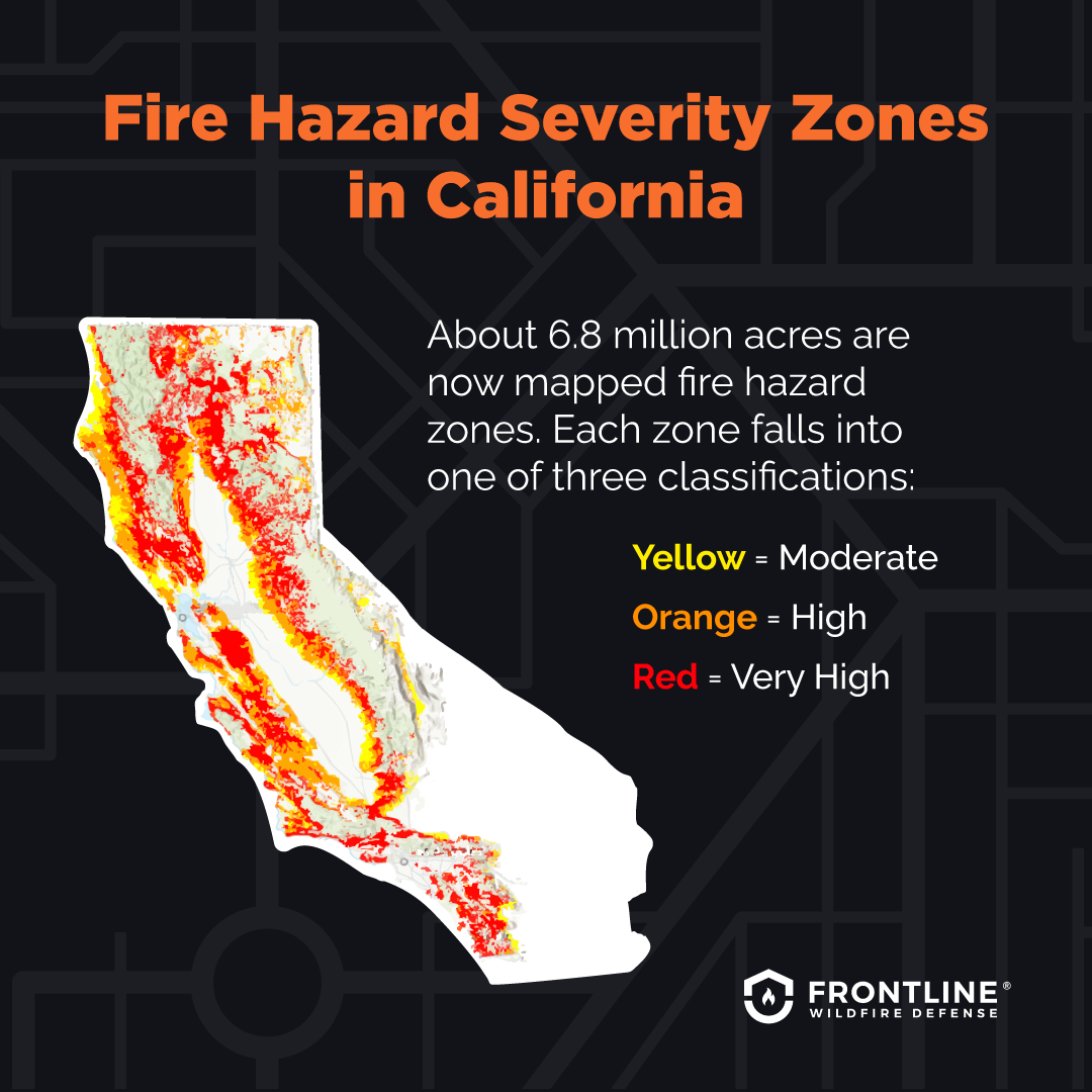
California’s vast geographical diversity means that fire risks and impacts can vary significantly from one region to another. While no area is entirely immune, certain regions are historically more prone to large, destructive fires.
Northern California Concerns: Forests and Wine Country
Northern California encompasses dense forests, mountainous terrains, and world-renowned wine regions. Areas like the Shasta Trinity National Forest, Mendocino National Forest, and the Sierra Nevada foothills are frequently impacted. The wine regions of Napa Valley and Sonoma County, while often recovering with remarkable resilience, have experienced devastating fires that affect wineries, vineyards, and local infrastructure.
Travelers planning to explore areas like Lake Tahoe for outdoor adventures, or the scenic drives through the Redwood National Park and other state parks, should be vigilant. Smoke plumes can travel far, affecting air quality around Lake Tahoe and even extending to urban centers like San Francisco. Road closures, particularly on routes like Highway 395 or smaller mountain roads, can severely limit access to trailheads and campsites.
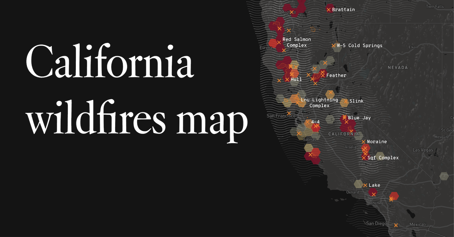
Central California Destinations: National Parks and Coastal Routes
Central California is home to some of the state’s most iconic national parks, including Yosemite National Park, Sequoia National Park, and Kings Canyon National Park. These parks, with their majestic sequoia groves and granite peaks, are often at risk due to their forested environments. Fires near these parks can lead to partial or full closures, impacting access to popular trails, campgrounds, and scenic overlooks. Smoke can also significantly obscure the views of famous landmarks like El Capitan or Half Dome in Yosemite.
The coastal stretch through Big Sur is another area susceptible to fires, which can lead to road closures on the Pacific Coast Highway (Highway 1). While the fires themselves might be inland, the winding roads through canyons and hillsides make access vulnerable. Always check Caltrans for real-time road conditions before embarking on a scenic drive.
Southern California Vulnerabilities: Mountains and Urban Interface
Southern California experiences its own unique fire challenges, often exacerbated by the infamous Santa Ana winds which fan flames across dry brush. Mountainous areas like the Angeles National Forest, San Bernardino National Forest, and Cleveland National Forest are frequent hotspots. Fires here can threaten communities nestled in the foothills, impacting travel routes that serve popular destinations like Palm Springs or the theme parks around Anaheim.
Even major metropolitan areas like Los Angeles and San Diego can experience significant impacts from distant fires, primarily through poor air quality. While the urban centers themselves are generally not directly threatened, the experience of visiting beaches or outdoor attractions can be diminished by hazy skies and the smell of smoke. Joshua Tree National Park and Death Valley National Park are desert environments but are not immune, especially during periods of extreme heat and lightning strikes.
Essential Resources for Travelers During Fire Season
Forewarned is forearmed. To navigate fire season effectively, travelers should rely on a consistent set of trusted information sources:
- Official Fire Agencies: The California Department of Forestry and Fire Protection (CAL FIRE) website is the authoritative source for statewide fire incidents, detailed maps, and containment information. The U.S. Forest Service provides updates for national forests.
- Air Quality Monitoring: Websites like AirNow.gov offer real-time air quality index (AQI) data, allowing travelers to assess conditions in their planned destinations. Many local air quality management districts also provide detailed regional reports.
- Road Conditions: Caltrans (California Department of Transportation) provides up-to-the-minute information on road closures and delays across the state’s highway system. This is crucial for planning driving routes.
- National Park Service and State Parks Websites: Always check the specific park website for current conditions, closures, and advisories before heading out.
- Local Tourism Boards: City and county tourism websites can offer localized information, including which businesses are open, alternative activities, and how to support affected communities.
- Travel Insurance: Consider purchasing travel insurance that covers fire-related disruptions, especially if traveling during peak fire season. Understand what your policy covers in terms of cancellations, delays, or medical emergencies due to smoke inhalation.
- Flexible Bookings: Whenever possible, choose accommodations and activities with flexible cancellation policies, allowing you to adapt your plans if conditions change unexpectedly.
Adapting Your California Itinerary: Safety and Sustainability
Even during fire season, California remains a captivating destination, but it requires a more flexible and informed approach to travel.
- Prioritize Safety: Never ignore evacuation orders or advisories. If an area is deemed unsafe, change your plans. Your safety and the safety of emergency responders are paramount.
- Consider Urban and Coastal Escapes: When inland areas or national parks are affected, pivot to California’s vibrant cities or expansive coastline. Cities like San Francisco, Los Angeles, San Diego, or charming coastal towns like Santa Barbara and Monterey often remain largely unaffected, offering world-class museums, dining, shopping, and beach access.
- Support Local Businesses: If you find yourself in an area affected by fire, either directly or indirectly, consider supporting local businesses that rely on tourism. Purchasing from local shops or dining at local restaurants can aid in their recovery.
- Practice Fire Prevention: Be a responsible traveler. Follow all fire restrictions, avoid campfires in prohibited areas, properly dispose of cigarettes, and be cautious with any spark-producing activities, especially in dry conditions.
- Embrace Flexibility: California’s weather and fire situation can change rapidly. Being prepared to alter your itinerary, choose alternative routes, or even switch destinations will help mitigate potential frustrations and ensure a smoother trip.
- Focus on Resilience: California’s communities and natural environments are incredibly resilient. Many areas bounce back, and visiting after a fire (when it’s safe and sustainable) can be a way to witness recovery and contribute to local economies.
By staying informed and adapting your plans with safety and responsibility in mind, you can still experience the magic of California, even when navigating the complexities of its fire season.
LifeOutOfTheBox is a participant in the Amazon Services LLC Associates Program, an affiliate advertising program designed to provide a means for sites to earn advertising fees by advertising and linking to Amazon.com. Amazon, the Amazon logo, AmazonSupply, and the AmazonSupply logo are trademarks of Amazon.com, Inc. or its affiliates. As an Amazon Associate we earn affiliate commissions from qualifying purchases.