
Understanding Wildfire Season in California
California, a jewel of diverse landscapes ranging from sun-drenched beaches to majestic mountain ranges, is a perennially popular travel destination. However, the state is also known for its annual wildfire season, a critical period that can significantly impact travel plans and experiences. Understanding the dynamics of these fires is the first step for any responsible traveler planning a visit.
The Annual Cycle and Its Impact on Travel
Wildfire season in California typically runs from late spring through late autumn, peaking during the dry, hot summer months and often exacerbated by seasonal winds like the Santa Anas in the south and the Diablos in the north. This period is characterized by increased fire risk due to dry vegetation, high temperatures, and low humidity. For travelers, this means a need for heightened awareness and flexibility. Fires can lead to sudden road closures, evacuation orders, air quality degradation, and the closure of popular attractions like national parks or state forests. While many parts of California remain unaffected, it’s crucial to stay informed about active incidents to ensure both safety and an enjoyable trip. The picturesque landscapes that draw millions—from the towering redwoods of Northern California to the desert expanses near Joshua Tree National Park—can quickly become hazardous if a fire ignites nearby. Proactive research and real-time monitoring are essential components of planning a successful journey during these months.
Key Factors Contributing to Wildfires
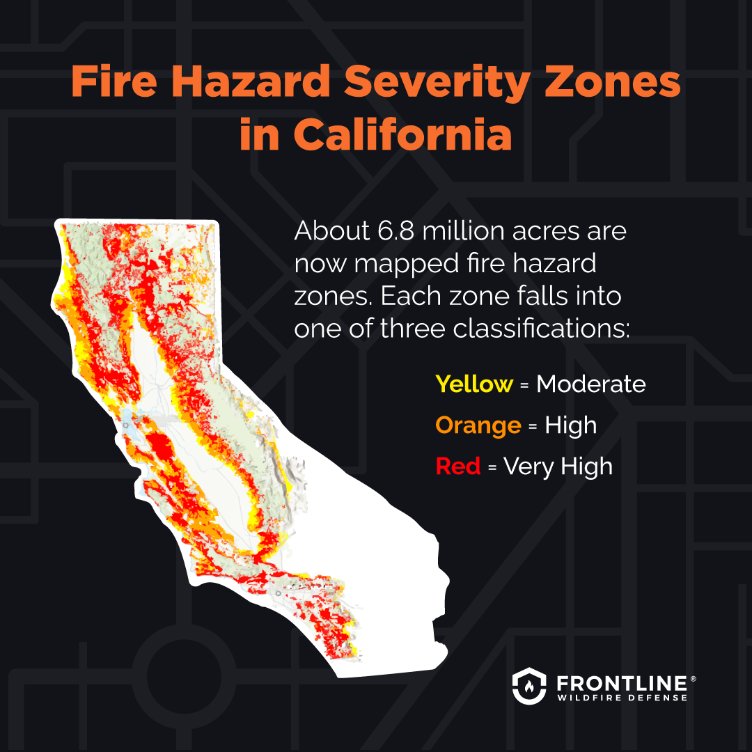
Several interconnected factors contribute to the intensity and frequency of wildfires in California. Prolonged droughts have left vegetation extremely dry, turning forests and grasslands into tinderboxes. High temperatures further desiccate the landscape, increasing flammability. Strong winds, characteristic of certain seasons and geographies within the state, can rapidly spread embers and intensify existing blazes, making containment challenging. Additionally, an accumulation of fuel, such as dead trees and undergrowth, resulting from historical fire suppression policies, creates conditions for larger, more destructive fires when they do occur. Human activity, both accidental and intentional, is often the ignition source for many fires, particularly near populated areas and recreational sites. Climate change is widely recognized as an amplifying factor, contributing to hotter, drier conditions and a longer, more severe fire season. Understanding these underlying causes helps travelers appreciate the scale of the challenge and the importance of adhering to fire safety guidelines.
Current Fire Status and Geographic Impact
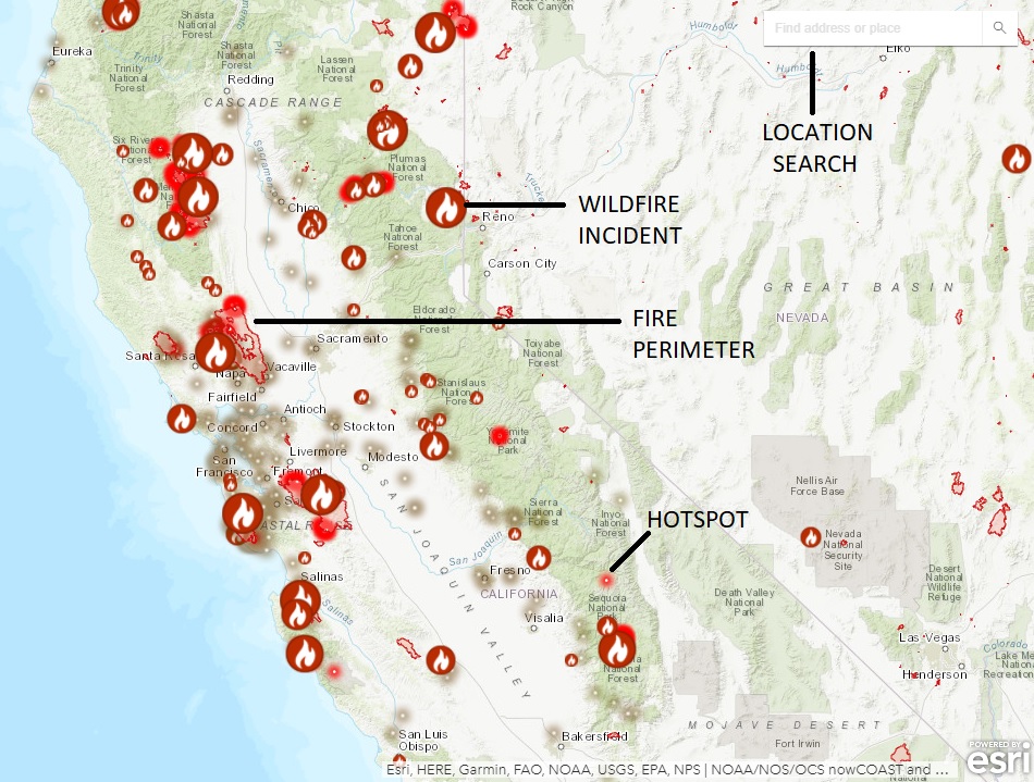
While specific fire incidents change daily, understanding general patterns and high-risk zones is vital for travel planning. This section provides a hypothetical overview of where fires might be concentrated, emphasizing the need for real-time information.
Northern California Hotspots
Northern California frequently faces wildfire challenges, particularly in its extensive forested areas and wine regions. The dry forests of the Sierra Nevada range, including areas surrounding Lake Tahoe, Yosemite National Park, Sequoia National Park, and Kings Canyon National Park, are often vulnerable. Further north, the vast stretches of the Mendocino National Forest and Shasta-Trinity National Forest can experience large, fast-moving fires that produce significant smoke, impacting air quality far beyond the immediate burn zones. The renowned wine regions of Napa Valley and Sonoma County, while often more resilient, have historically been affected by blazes that threaten vineyards, resorts, and tourism infrastructure, leading to closures and disruptions during peak season. Travelers heading to these areas should closely monitor local fire alerts and air quality reports before and during their trip.
Central Coast and Sierra Foothills Considerations
The Central Coast region, famous for its scenic beauty along Pacific Coast Highway (Highway 1) and iconic destinations like Big Sur, is also susceptible to wildfires, particularly in its chaparral-covered hillsides. Fires here can lead to immediate road closures, sometimes isolating communities and impacting coastal travel routes. The Sierra Foothills, serving as the gateway to the Sierra Nevada and historic Gold Country towns, face similar risks. These areas are characterized by a mix of residential communities and wildlands, making fire management complex. Smoke from fires originating deeper in the mountains can drift into these foothill towns, affecting outdoor activities and local businesses. When planning a drive along the coast or a visit to quaint foothill towns, it’s prudent to check for any active incidents that could necessitate route changes or alternative arrangements.
Southern California Regions to Monitor
Southern California, with its dense population centers nestled against wildland-urban interfaces, faces unique wildfire challenges. Areas around Los Angeles, Santa Barbara, and San Diego, particularly the hills and canyons prone to Santa Ana winds, are frequently impacted. The dry, brushy hillsides ignite easily, and strong winds can push fires rapidly into developed areas. Even if directly unaffected, major cities can experience poor air quality due to smoke plume drift. Destinations like Joshua Tree National Park and other desert parks, while seemingly less susceptible, can experience desert fires that are equally destructive to their unique ecosystems. Travelers heading to Southern California must prioritize understanding local fire alerts and emergency information, especially when venturing into natural areas or planning outdoor activities.
Navigating Travel During Wildfire Season
Traveling through California during wildfire season requires an informed and cautious approach. Preparation is key to ensuring a safe and enjoyable journey.
Essential Resources for Real-Time Updates
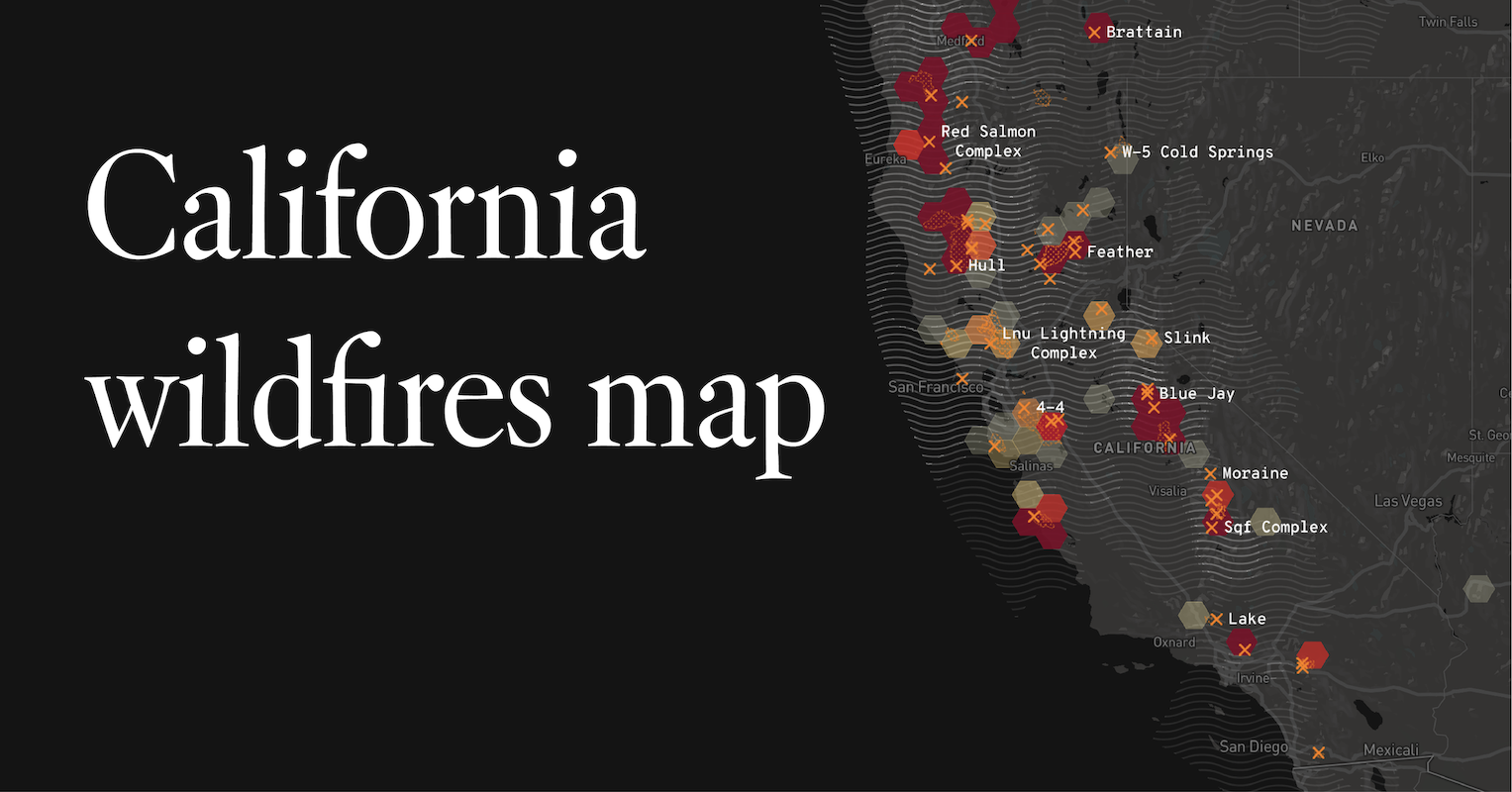
Staying informed is paramount. Official government agencies are the most reliable sources for real-time fire information. The California Department of Forestry and Fire Protection (Cal Fire) provides daily incident reports, interactive fire maps, and public safety information. The National Interagency Fire Center (NIFC) also offers a national overview that includes California incidents. For road closures, the California Department of Transportation (Caltrans) website is indispensable, providing up-to-the-minute updates on highway conditions, closures, and alternative routes. Local sheriff’s departments and emergency services often issue immediate evacuation orders and local alerts via their websites and social media channels. Travelers should bookmark these resources and check them frequently, not just before departure, but throughout their trip. Signing up for local emergency alerts in the areas you plan to visit can also provide critical, timely notifications directly to your phone.
Air Quality and Health Precautions
Smoke from wildfires can travel hundreds of miles, significantly impacting air quality even in areas not directly threatened by fire. Elevated levels of fine particulate matter (PM2.5) in the air can cause respiratory problems, especially for vulnerable individuals such as children, the elderly, and those with pre-existing conditions like asthma or heart disease. Websites like AirNow.gov provide real-time air quality maps and forecasts, utilizing data from the Environmental Protection Agency (EPA). The California Air Resources Board (CARB) also offers detailed state-specific information. If air quality is poor, travelers should limit outdoor activities, keep windows and doors closed, use air purifiers if available in accommodations, and wear N95 masks if venturing outdoors is unavoidable. Always consult the CDC or a healthcare professional for specific health advice related to smoke exposure.
Road Closures and Evacuation Routes
Wildfires often necessitate swift road closures for public safety, fire suppression efforts, and to facilitate evacuations. These closures can be dynamic and unpredictable, changing within hours. Before embarking on any road trip in California, especially during wildfire season, travelers should consult Caltrans QuickMap or use reliable navigation apps that incorporate real-time traffic and closure data. It’s also wise to have a physical map or an offline map download, as cell service can be unreliable in remote areas, particularly during emergencies. Furthermore, familiarize yourself with potential evacuation routes for your planned destinations. Local authorities will designate these routes, and knowing them in advance can save critical time if an emergency arises. Never attempt to drive through areas with active fires or where “road closed” signs are posted. Following these directives is crucial for your safety and the safety of emergency personnel.
Adjusting Your California Travel Plans
Flexibility is a traveler’s greatest asset when visiting California during wildfire season. Having contingency plans can mitigate disruptions and salvage your trip.
Flexibility is Key
Given the unpredictable nature of wildfires, maintaining a flexible itinerary is paramount. Avoid booking non-refundable activities or accommodations too far in advance, especially in high-risk areas. Consider purchasing travel insurance that covers wildfire-related cancellations or interruptions. Be prepared to shift your plans, perhaps opting for coastal destinations if inland areas are affected by smoke, or exploring cities if natural parks are closed. Having backup destinations or alternative activities in mind can reduce stress and allow you to adapt gracefully to unforeseen circumstances. Local tourism boards and visitor centers can be excellent resources for identifying unaffected areas and alternative experiences. Embracing flexibility allows for spontaneous discoveries and ensures that your trip remains enjoyable despite potential environmental challenges.
Exploring Alternative Destinations
If your initial chosen destination is directly impacted by fire or experiencing poor air quality, consider shifting your focus to other parts of California. For instance, if Yosemite National Park is affected, you might explore the untouched beauty of the Redwood National and State Parks further north, or the vibrant urban landscapes of San Francisco, Los Angeles, or San Diego, which often remain unaffected by specific regional fires. The diverse geography of California means that clear skies and open roads are often just a few hours’ drive away. Research areas known for their low fire risk or those historically less impacted during peak season. This might include certain coastal cities or higher elevation regions away from heavy forest cover. Remember that the goal is to experience California’s beauty safely and enjoyably, even if it means adjusting your initial vision.
Insurance and Rebooking Policies
Before booking your trip, thoroughly review the cancellation and rebooking policies of your accommodations, airlines, and tour operators. Understand what circumstances qualify for refunds or changes, particularly regarding natural disasters like wildfires. Many travel insurance policies offer coverage for trip interruption or cancellation due to mandatory evacuations or widespread travel advisories. However, it’s crucial to read the fine print; standard policies may not cover cancellations due to smoke alone, unless an official warning or closure is in place. Consider a “cancel for any reason” (CFAR) policy if you desire maximum flexibility, though these are typically more expensive. Document all communications, receipts, and official advisories should you need to file a claim. Proactive engagement with your travel providers and insurance company can save significant financial loss and stress.
Responsible Tourism Practices
Even when fires are not active, promoting responsible tourism is vital for the long-term health of California’s natural environments and communities.
Fire Prevention Tips for Travelers
Travelers have a significant role to play in preventing wildfires. Always adhere to local fire restrictions, which can include bans on campfires, charcoal grills, or specific recreational activities during high fire danger. Never throw cigarette butts out of car windows; dispose of them properly in designated receptacles. When camping, ensure campfires are completely extinguished with water and cold to the touch before leaving. Park vehicles only in designated areas and avoid parking on dry grass, as hot exhaust systems can easily ignite vegetation. Be mindful of trailer chains dragging, as they can create sparks. Avoid using any equipment that can spark, such as grinders or welders, in dry outdoor environments. Educate yourself and your travel companions about the “Leave No Trace” principles, which include being careful with fire. Report any suspicious activity or unattended fires immediately to authorities like 911 or the US Forest Service. By practicing these simple precautions, travelers contribute directly to protecting California’s natural beauty and its communities.
Supporting Affected Communities
When wildfires impact a region, local businesses, especially those reliant on tourism, suffer significant economic setbacks. If you find your travel plans disrupted, consider how you can still support the affected communities. This might involve purchasing gift certificates from local restaurants, wineries, or shops for future use, or donating to reputable local relief organizations. If a specific area is safe to visit but has experienced recent fires, making an effort to patronize local businesses during your revised trip can be incredibly beneficial. Recovery efforts often extend long after the flames are out, and sustained support from visitors can help these communities rebuild and thrive. Before donating, research organizations to ensure they are legitimate and effective. Engaging thoughtfully with communities, whether through direct support or respectful visitation once it is safe, embodies the spirit of responsible and compassionate travel.
LifeOutOfTheBox is a participant in the Amazon Services LLC Associates Program, an affiliate advertising program designed to provide a means for sites to earn advertising fees by advertising and linking to Amazon.com. Amazon, the Amazon logo, AmazonSupply, and the AmazonSupply logo are trademarks of Amazon.com, Inc. or its affiliates. As an Amazon Associate we earn affiliate commissions from qualifying purchases.