
California, a land of diverse landscapes from sun-drenched beaches to towering mountain ranges, draws millions of travelers annually. However, its natural beauty is often accompanied by the challenging reality of wildfires, particularly during the dry season. For any traveler planning a trip to the Golden State, understanding where wildfires typically occur, how to monitor current situations, and how to plan a safe and enjoyable journey is paramount. This guide provides essential insights for navigating California responsibly, ensuring your travel experiences remain memorable for all the right reasons.
Understanding California’s Wildfire Landscape
Wildfires are a natural, albeit often destructive, part of California’s ecology. A combination of factors makes the state particularly susceptible, influencing where and when fires are most likely to ignite and spread. For travelers, comprehending this landscape is the first step in informed planning.
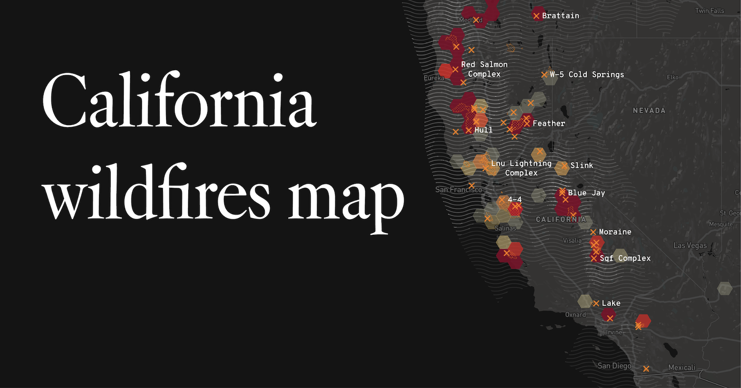
Key Factors Contributing to Wildfires
California’s Mediterranean climate is characterized by hot, dry summers and mild, wet winters. This cycle creates abundant vegetation growth during cooler months, which then dries out and becomes highly flammable fuel by late summer and fall. Drought conditions, which have become increasingly frequent and severe, exacerbate this situation, turning vast expanses of forests and chaparral into tinderboxes. Topography also plays a critical role; steep canyons and hillsides can act as natural chimneys, accelerating fire spread and making containment challenging. Strong winds, especially the infamous Santa Ana winds in Southern California and Diablo winds in Northern California, can push flames rapidly across vast distances, often causing fires to grow exponentially in a matter of hours. Human activity, both accidental and intentional, remains the leading cause of ignitions, although lightning strikes are also a significant factor in remote areas.
Historical Patterns and Seasonal Considerations
Historically, California’s wildfire season typically peaks from late summer through fall, roughly August to November. This period coincides with the driest conditions and the onset of strong seasonal winds. However, climate change has led to a noticeable expansion of the fire season, with significant blazes now occurring year-round in some parts of the state. Early summer fires are becoming more common, and even winter months can see activity if conditions are unusually dry. Certain regions are perpetually more prone to wildfires due to their vegetation, climate, and topography. These include the wildland-urban interface areas found throughout the Sierra Nevada foothills, the coastal mountains of Southern California, and the dense chaparral areas of Napa Valley and Sonoma County. Understanding these patterns allows travelers to assess risk levels for their intended destinations based on the time of year.
Navigating Travel During Fire Season: Safety and Planning
Traveling through California during wildfire season requires vigilance and adaptability. While it’s impossible to predict every fire, being prepared and staying informed can make all the difference in ensuring a safe trip.
Essential Resources for Real-Time Information
The most critical aspect of traveling during wildfire season is access to up-to-date, reliable information. Rely exclusively on official sources for real-time wildfire maps, incident details, and emergency alerts. The California Department of Forestry and Fire Protection (CAL FIRE) website is an indispensable resource, offering interactive maps and incident reports that track current fires. The National Interagency Fire Center (NIFC) also provides broader national wildfire information. For local conditions, check county sheriff’s department websites and emergency management agencies for specific evacuation orders and road closures in the areas you plan to visit. Many news outlets also offer continuously updated wildfire coverage. Bookmark these resources before your trip and check them daily, or even hourly, especially if you are in or near a high-risk area. Social media can be useful for quick updates, but always cross-reference information with official sources to avoid misinformation.
Air Quality Considerations and Health Precautions
Beyond the immediate danger of flames, wildfire smoke poses a significant health risk. Smoke plumes can travel hundreds of miles, impacting air quality far from the actual fire location. Before traveling to or through California, and certainly during your trip, monitor air quality reports. Websites like AirNow.gov provide real-time Air Quality Index (AQI) readings, indicating levels of particulate matter and other pollutants. An AQI above 100 is generally considered unhealthy for sensitive groups, and above 150, unhealthy for everyone. If air quality is poor, especially if you have respiratory conditions, consider modifying your itinerary to avoid outdoor activities or even altering your destination. Wearing N95 masks can offer some protection against smoke particles. Keeping car windows closed and using the recirculate function for air conditioning can also help maintain better air quality inside your vehicle. Prioritize your health and be prepared to adjust plans if smoke conditions are severe.
Evacuation Zones and Road Closures
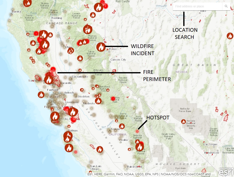
Wildfires frequently necessitate evacuation orders and lead to road closures, which can severely disrupt travel plans. Always be aware of your location relative to any active fire perimeters and potential evacuation zones. Official sources will provide detailed maps of these areas. If an evacuation order is issued for a region you are in, leave immediately and follow all instructions from emergency personnel. Do not wait for conditions to worsen. Road closures are common to allow emergency vehicles access, protect the public, or due to fallen trees and debris. Use mapping applications like Google Maps or Waze, but always cross-reference with official state highway patrol and county road department websites for the most accurate and current road status information. Being rerouted due to closures can add significant time to your journey, so factor in flexibility and alternative routes when planning your daily drives.
Current Wildfire Hotspots and Affected Regions (General Overview)
While specific fire locations are dynamic and constantly changing, understanding the regions historically and frequently impacted by wildfires can help travelers make informed decisions. This overview provides a general sense of areas that often experience significant fire activity.
Northern California Overview
Northern California often faces intense wildfire activity, particularly in its forested and rural areas. The mountainous regions, including the Shasta County area and the vast expanses of the Klamath, Mendocino, and Plumas National Forests, are frequently sites of large and challenging fires. These fires can impact major transportation arteries like I-5, affecting travel to popular spots like Mount Shasta and the remote beauty of the far north. Further south, the wine country regions of Napa Valley and Sonoma County have unfortunately seen devastating fires in recent years. While these areas are resilient and rebuilt, travelers should still monitor conditions closely, as the dense vegetation and rolling hills create a high-risk environment. The proximity to metropolitan areas like Sacramento means smoke impacts can extend far beyond the immediate fire zones, influencing air quality across large swaths of Northern California.
Central and Southern California Landscape
Central California, particularly the Sierra Nevada foothills and the vast agricultural lands of the Central Valley, also experiences regular wildfire activity. The gateway communities to Yosemite National Park, Sequoia National Park, and Kings Canyon National Park are often at risk, and park access can be limited or restricted due to fires or smoke. Even iconic destinations like Lake Tahoe, nestled in the Sierra Nevada, have been threatened.
Southern California is particularly susceptible to fast-moving, wind-driven fires, often fueled by chaparral and dense brush. Los Angeles County, Orange County, Riverside County, and San Diego County all have significant wildland-urban interface areas. The Santa Ana winds, typically occurring from fall through early winter, can rapidly spread fires from the mountains and canyons towards populated coastal areas. While major urban centers like Los Angeles and San Diego are generally less directly threatened by flames, they frequently experience poor air quality due to smoke, which can affect outdoor activities and overall enjoyment of these vibrant cities. Coastal highways, such as sections of Highway 1 along Big Sur, can also be impacted by fires in adjacent steep terrain.
Alternative Destinations and Adapting Your California Itinerary
Flexibility is a traveler’s best friend during California’s wildfire season. Having alternative plans or being willing to adjust your itinerary can save your trip from being derailed by unforeseen events.
Coastal Escapes Away From Fire Risk
When inland areas are experiencing fire activity or heavy smoke, California’s extensive coastline often offers a respite. Coastal breezes typically push smoke inland, leaving beach destinations with clearer air. Cities like San Francisco, Monterey, Santa Barbara, and San Diego can be excellent choices, offering a wealth of attractions, dining, and cultural experiences without the immediate threat or air quality issues associated with wildfires. Consider exploring the rugged beauty of the Redwood National Park and State Parks along the northern coast, where the moist climate generally reduces fire risk compared to inland forests. Surfing, whale watching, exploring charming seaside towns, or simply relaxing on the beach can provide a perfect alternative to smoky mountain trails.
Urban Adventures: San Francisco, Los Angeles, and Beyond
California’s major urban centers offer an incredible array of indoor attractions and city-based experiences that are largely unaffected by wildfires, except perhaps for occasional distant smoke. In San Francisco, explore museums like the de Young Museum or the California Academy of Sciences, visit Alcatraz Island, or enjoy the culinary scene. Los Angeles boasts world-class museums such as The Getty Center and LACMA, vibrant neighborhoods, and entertainment studios. Even if the skies are hazy, these cities offer countless indoor activities, from shopping and fine dining to theatrical performances and sporting events. Many smaller cities like Pasadena, Oakland, and Long Beach also offer unique cultural attractions, historical sites, and diverse food scenes, providing ample opportunities for a fulfilling trip away from wildfire concerns.

Supporting California Safely
When wildfires occur, local communities, especially those reliant on tourism, can face significant economic hardship. Traveling to safe areas of California and supporting local businesses is a valuable way to contribute to the state’s recovery and resilience. Before canceling a trip entirely, consider adjusting your destination to an unaffected region. Many parts of California are always open for business, even during peak fire season. By staying informed, being flexible, and choosing your destinations wisely, you can still have an incredible California adventure while prioritizing safety and supporting the state’s vibrant tourism economy. Always remember to check with your accommodation providers, tour operators, and local tourism boards for the most current advice specific to your travel plans.
LifeOutOfTheBox is a participant in the Amazon Services LLC Associates Program, an affiliate advertising program designed to provide a means for sites to earn advertising fees by advertising and linking to Amazon.com. Amazon, the Amazon logo, AmazonSupply, and the AmazonSupply logo are trademarks of Amazon.com, Inc. or its affiliates. As an Amazon Associate we earn affiliate commissions from qualifying purchases.