
California is a land shaped by dramatic geological forces, a reality profoundly evident in its famed earthquake fault lines. These natural features are not merely lines on a map; they are dynamic boundaries where the Earth’s tectonic plates grind past each other, creating the stunning mountain ranges, valleys, and coastal formations that define the state’s iconic landscape. Far from being hidden, many of these fault lines, particularly the legendary San Andreas Fault, are tangible geological landmarks, visible testaments to the planet’s continuous, slow-motion ballet of creation and destruction. Understanding their location and characteristics offers a unique window into the natural history and ongoing evolution of this remarkable state. For anyone seeking to grasp the fundamental forces that have sculpted California into the vibrant, diverse region it is today, these fault lines stand as monumental, living features of the natural world.

The San Andreas Fault: California’s Defining Geological Landmark
The undisputed titan of California’s geological landscape is the San Andreas Fault, an epic scar on the Earth’s surface that stretches for approximately 800 miles (1,300 kilometers) from the Salton Sea in the south to Cape Mendocino in the north. This colossal strike-slip fault marks the primary boundary between two immense tectonic plates: the Pacific Plate to the west, moving northwest, and the North American Plate to the east, moving southeast. The slow, relentless grinding of these plates, at an average rate of about 1.5 inches (3-5 cm) per year, is the engine behind California’s seismic activity and the dramatic geological features observed across the state.
As a natural landmark, the San Andreas Fault is not a single, continuous crack but rather a complex zone of shattered rock, often manifesting as a linear valley, a series of parallel ridges, or distinct offsets in the landscape. One of the most visually striking segments of the fault can be observed in the Carrizo Plain National Monument, east of San Luis Obispo. Here, the fault appears as a prominent, almost perfectly straight furrow cutting across the desert floor, often accentuated by different vegetation patterns. A prime example of its visible activity is Wallace Creek, an ephemeral stream that has been dramatically offset by hundreds of feet over thousands of years, offering a textbook illustration of strike-slip faulting.
Further north, the fault runs through the Mojave Desert, shaping the foothills of the San Gabriel Mountains and influencing the topography near Los Angeles. It continues northward through the Transverse Ranges and the Diablo Range, eventually passing just offshore from San Francisco at places like the Point Reyes National Seashore, where Tomales Bay itself is a fault-formed trough. The linear nature of these valleys, canyons, and even bays are enduring natural monuments to the fault’s pervasive influence on the landscape.
Beyond the San Andreas Fault: A Network of Active Faults
While the San Andreas Fault is the most famous, California is crisscrossed by a complex web of hundreds of other active fault lines, many of which are significant geological landmarks in their own right. These secondary faults accommodate the distributed deformation caused by the larger plate boundary, each contributing to the state’s distinctive topography and seismic character.
Major Companion Faults of Southern California
In Southern California, several prominent faults run roughly parallel to the San Andreas Fault, shouldering some of the tectonic strain. The San Jacinto Fault, for instance, is considered one of the most active faults in California and runs through populous areas from the Salton Trough northwest through Riverside County. Its path is often marked by linear valleys and distinct changes in elevation, particularly noticeable in the mountainous terrain it traverses.
Further west, closer to the coast, lies the Newport-Inglewood Fault. This fault zone extends from offshore San Diego through urban centers like Long Beach and Los Angeles. While less visibly obvious as a single continuous line due to urban development, its presence is highlighted by a chain of hills and mesas, such as the Baldwin Hills and Signal Hill, which are uplifts along the fault trace. These features, now embedded within the cityscape, serve as subtle but powerful natural landmarks denoting the underlying geological structure.
The Garlock Fault is another critical player, a left-lateral strike-slip fault that runs almost perpendicular to the San Andreas Fault across the Mojave Desert. It forms the northern boundary of the Mojave Block, influencing the orientation of mountain ranges and valleys in this arid region, creating distinct geological breaks and linear features that are easily discernible to the discerning eye.
Faults of the San Francisco Bay Area
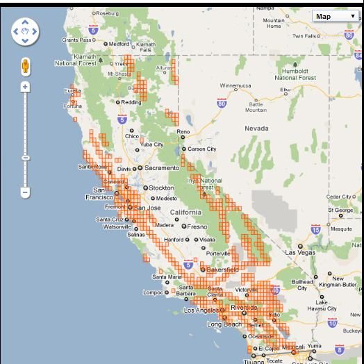
North of Los Angeles, the San Francisco Bay Area is shaped by several major faults in addition to the nearby San Andreas Fault. The Hayward Fault, located on the eastern side of San Francisco Bay, is particularly active and known for its “creeping” sections, where the fault slowly moves without major earthquakes. This creep is visible in offset curbs, cracked pavement, and distorted building foundations in cities like Hayward and Fremont. These visible deformations, though subtle, are compelling, almost intimate, natural landmarks of ongoing geological processes.
Other significant faults in the region include the Rodgers Creek Fault, Calaveras Fault, and Concord-Green Valley Fault, all contributing to the region’s complex seismic tapestry. Each of these fault zones leaves its signature on the landscape, carving valleys, uplifting hills, and influencing drainage patterns, making them integral elements of California’s natural landmarks.
Understanding Fault Lines as Natural Landmarks
Beyond their role in seismic activity, California’s fault lines are profound natural landmarks that shape ecosystems, influence hydrology, and tell a story of deep time and constant change. Their very presence creates unique environments.
Geological Features and Biodiversity Hotspots
The linear valleys and depressions formed by fault lines often become natural conduits for rivers and streams, leading to the formation of sag ponds and wetlands. These water features, constrained by geological forces, can create microclimates and unique habitats that support diverse plant and animal life, making them ecological landmarks within the broader geological context. For example, specific fault-generated springs in the Mojave Desert are vital oases for desert wildlife.
The uplift and subsidence associated with fault movement also create distinct topographic features. Mountain ranges, like the Temblor Range bordering the Carrizo Plain, owe their existence to tectonic squeezing along the San Andreas Fault. Conversely, basins like the Coachella Valley are fault-bounded depressions. These grand-scale features are not just geological curiosities but are defining elements of California’s renowned natural beauty and are experienced as fundamental landmarks of the state’s geography.
Educational and Interpretive Significance
As natural landmarks, fault lines offer unparalleled educational opportunities. Sites like Wallace Creek or the offset features in Hollister and Parkfield provide tangible, real-world laboratories for understanding plate tectonics. Geological tours and interpretive centers, particularly along the San Andreas Fault near Palm Springs or in the Carrizo Plain, guide visitors to observe these phenomena firsthand. They transform abstract geological concepts into concrete, visible landscapes, fostering a deeper appreciation for the planet’s dynamic processes. The very act of observing a fault line, understanding its history, and witnessing its ongoing effects is an engagement with a fundamental aspect of natural history and the science of our Earth.

Experiencing California’s Dynamic Geology
To truly appreciate California’s earthquake fault lines as natural landmarks is to engage with the state’s living geology. This involves seeking out places where the fault’s influence is palpably present and visible on the landscape.
One of the most accessible and visually stunning locations is the Carrizo Plain National Monument. Here, visitors can hike along trails that cross the San Andreas Fault itself, observing the distinctive sag ponds, pressure ridges, and the famous offset stream of Wallace Creek. The sheer scale and clarity of the fault trace across this undeveloped landscape provide an awe-inspiring perspective on its power. Similarly, the Point Reyes National Seashore offers trails and interpretive exhibits that showcase the impact of the San Andreas Fault on the coastal environment, including the dramatic depression of Tomales Bay.
In the Palm Springs area, organized tours often delve into the fault system of the Coachella Valley, allowing participants to see exposed fault lines, learn about the region’s geological history, and understand how the desert landscape has been shaped. These excursions typically highlight features such as palm oases, which often emerge where groundwater is forced to the surface by fault lines.
While awareness of seismic activity is a part of life in California, engaging with these geological landmarks is about profound respect for the Earth’s enduring power. It is an opportunity to connect with the very foundations of the land, to witness the continuous forces that have carved mountains and valleys, and to appreciate the dynamic, ever-changing nature of our planet. These fault lines are more than just earthquake hazards; they are monumental natural sculptures, foundational landmarks, and integral threads in the rich tapestry of California’s natural identity.
LifeOutOfTheBox is a participant in the Amazon Services LLC Associates Program, an affiliate advertising program designed to provide a means for sites to earn advertising fees by advertising and linking to Amazon.com. Amazon, the Amazon logo, AmazonSupply, and the AmazonSupply logo are trademarks of Amazon.com, Inc. or its affiliates. As an Amazon Associate we earn affiliate commissions from qualifying purchases.