
The distinctive geometric outline of Colorado is not merely a cartographic curiosity but a profound reflection of its history, geography, and the very character of its renowned landmarks. Unlike many states whose borders meander along rivers or follow natural topographical features, Colorado presents an almost perfect rectangle, a testament to an era of precise surveying and political ambition. This unique shape profoundly influences how we perceive and explore its famous places, from towering peaks to ancient dwellings.
The Geometric Marvel: Colorado’s Distinctive Borders
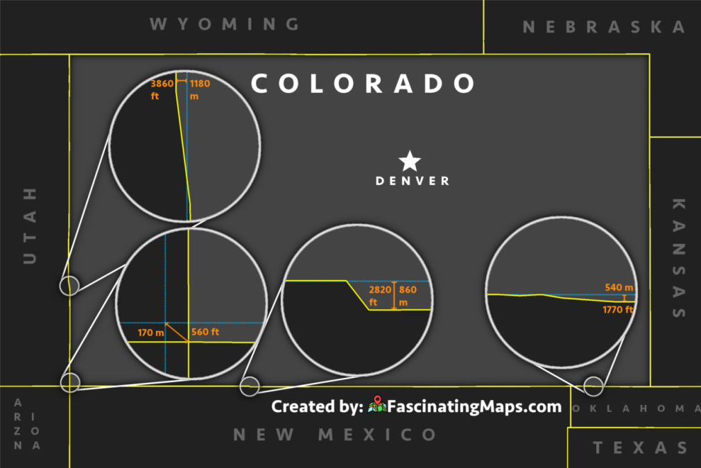
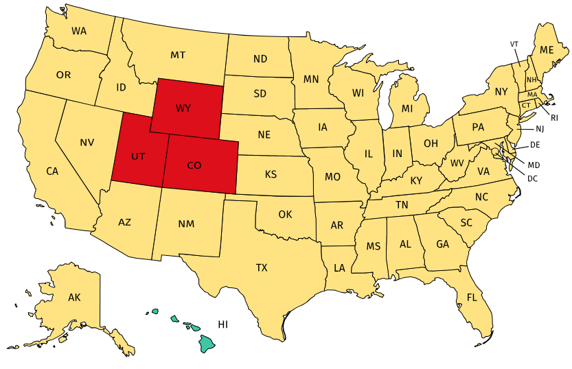
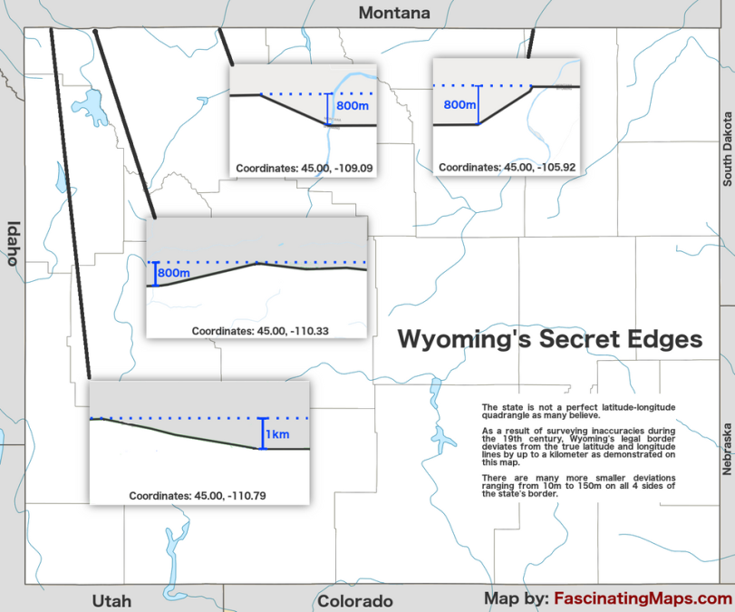
At first glance, Colorado stands out on any map of the United States as one of only three states (alongside Wyoming and Utah) with borders composed entirely of straight lines of latitude and longitude. This intentional design, largely laid out in the mid-19th century, creates a nearly perfect rectangular prism that defines the state’s boundaries with its neighbors: Wyoming to the north, Nebraska and Kansas to the east, Oklahoma and New Mexico to the south, and Utah to the west. This grid-like precision is a direct consequence of historical surveying practices and the desire for clear, unambiguous territorial definitions in a rapidly expanding nation.
A Legacy of Surveying and Straight Lines
The precise rectangular shape of Colorado emerged from the era of westward expansion, particularly following the Louisiana Purchase and the subsequent land acquisitions. When the Colorado Territory was established in 1861, its boundaries were set using specific meridians of longitude and parallels of latitude. This was a common practice for territories in the American West, where natural features were less distinct or less convenient for demarcation. Surveyors, using early but remarkably accurate instruments, meticulously plotted these lines, often over vast and challenging terrains, including the rugged Rocky Mountains. The boundaries were set between 37° N and 41° N latitude and 102° W and 109° W longitude. This geometric approach allowed for a straightforward administration of land and resources, particularly important during the Gold Rush that fueled the territory’s rapid growth.
How Geography Meets Governance
The choice of straight lines for Colorado’s borders meant that the political boundaries did not necessarily align with geographical features. This led to a unique situation where diverse landscapes—from the arid plains to the east, through the majestic Rocky Mountains forming the state’s spine, to the plateaus and canyonlands of the west—were all contained within one neatly defined rectangle. This artificial boundary creation, while efficient for governance, also meant that communities and natural ecosystems were sometimes divided or grouped together in ways that transcended natural divides. The famous Four Corners monument, where Colorado, Utah, Arizona, and New Mexico meet at a single point, is the most iconic representation of this geometric approach to statehood, drawing visitors who marvel at the precision of the intersection.
Beyond the Lines: Natural Wonders within the Rectangle
Within Colorado’s precise rectangular confines lies a landscape of staggering diversity and grandeur, home to some of the nation’s most celebrated natural landmarks. The state’s shape effectively encapsulates a micro-continent of ecosystems, driven largely by the presence of the Rocky Mountains.
The Rocky Mountains and the Continental Divide
The imposing Rocky Mountains dominate the western and central parts of Colorado, their jagged peaks and vast wilderness areas being the state’s most iconic natural landmarks. Running north to south through the heart of these mountains is the Continental Divide, a hydrological boundary that dictates the flow of water across the continent. To the east, rivers empty into the Atlantic Ocean; to the west, they flow towards the Pacific Ocean. This monumental geological feature is not just a landmark in itself but also creates distinct climatic zones and supports an incredible array of biodiversity.
The state boasts 58 peaks over 14,000 feet, known as “Fourteeners,” including Mount Elbert, the highest point in the Rocky Mountains. These peaks, along with vast national forests like the Roosevelt National Forest and national parks such as Rocky Mountain National Park, offer unparalleled opportunities for outdoor exploration and serve as critical habitats for wildlife. The straight-line boundaries of the state effectively cut across and contain significant portions of these mountain ranges, making Colorado synonymous with high-altitude alpine environments.
Plateaus, Canyons, and Deserts
While the mountains define much of Colorado’s identity, its rectangular shape also encompasses dramatically different landscapes. To the east, the state gradually descends into the Great Plains, characterized by vast agricultural lands and a semi-arid climate. To the west, beyond the main ranges of the Rockies, lies a region of stunning plateaus, mesas, and deep canyons carved by ancient rivers.
This western slope is home to formations like the dramatic Black Canyon of the Gunnison National Park, a chasm of extraordinary depth and steepness. Further west, the landscape transforms into more arid desert environments, bordering Utah, featuring unique geological formations and ancient cultural sites. The diversity contained within Colorado’s regular boundaries is remarkable, showcasing everything from alpine tundra to desert scrublands, each ecosystem supporting distinct natural landmarks and historical narratives.
Iconic Landmarks Defined by its Form
The distinct shape of Colorado has not only provided a canvas for natural wonders but has also shaped the development and location of its most famous human-made and natural landmarks. The rectilinear boundaries delineate a region rich in history and geological marvels, many of which draw millions of visitors annually.
Denver: The Mile High City’s Location
Denver, the state capital and largest city, is prominently situated at the eastern edge of the Front Range of the Rocky Mountains. Its location, roughly in the center of the eastern half of the rectangle, made it a natural hub for transportation and commerce during the state’s formative years. As a gateway to the mountains and a nexus for the plains, Denver became the administrative and economic heart of the territory, a position reinforced by the state’s defined boundaries. Landmarks within and near Denver, such as the historic Union Station and the vibrant Larimer Square, owe their prominence to the city’s strategic placement within the rectangular state. Just south, Colorado Springs offers another major urban landmark, home to Pikes Peak and the otherworldly formations of Garden of the Gods, all nestled within the same Front Range setting.
Mesa Verde National Park’s Ancient Dwellings
In the southwestern corner of Colorado, a region directly influenced by the state’s precise corner at the Four Corners, lies Mesa Verde National Park. This UNESCO World Heritage Site is renowned for its remarkably well-preserved Ancestral Puebloan cliff dwellings, built into the alcoves of canyons. The park’s existence within Colorado’s boundaries highlights how the state’s shape encompasses not only diverse natural environments but also rich historical and archaeological landmarks that tell the story of ancient civilizations. The unique geography of the mesa country, protected within the state’s southwest quadrant, provides the perfect conditions for the preservation of these invaluable historical sites.
Great Sand Dunes National Park and Preserve’s Unique Landscape
Further south, within the vast San Luis Valley and against the backdrop of the Sangre de Cristo Mountains, is Great Sand Dunes National Park and Preserve. This extraordinary landmark features the tallest sand dunes in North America, an anomaly of towering sand within a mountainous state. The specific geographical forces that created and sustain these dunes – prevailing winds and mountain barriers – are contained wholly within Colorado’s borders. The state’s rectangular definition thus encompasses a complete, self-contained geographical system that produces such a unique and iconic natural feature, demonstrating the incredible environmental diversity framed by its straight-line design.
The Shape’s Enduring Impact on Identity and Exploration
The distinctive shape of Colorado is more than just an arbitrary delineation on a map; it has become an integral part of the state’s identity. This geometric precision, born from historical necessity, has framed a remarkable collection of natural and cultural landmarks. From the majestic heights of the Collegiate Peaks and the serene beauty of Maroon Bells to the paleontological wonders of Florissant Fossil Beds National Monument and Dinosaur National Monument, Colorado’s shape holds a universe of discovery. Whether visitors are exploring the historic hot springs of Glenwood Springs or gazing from the dizzying heights of the Royal Gorge Bridge and Park, the experience is always within the context of this uniquely shaped state.
The rectangular design means that, no matter where one stands in Colorado, one is within an implicitly defined space, a product of human intention overlaid upon immense natural forces. This contributes to a sense of place that is both vast and meticulously ordered. The question “What shape is Colorado?” thus leads not just to a simple geometric answer but to a deeper understanding of how geographical and political boundaries can frame, influence, and define the very essence of a landmark-rich region, shaping both its history and its future exploration.
LifeOutOfTheBox is a participant in the Amazon Services LLC Associates Program, an affiliate advertising program designed to provide a means for sites to earn advertising fees by advertising and linking to Amazon.com. Amazon, the Amazon logo, AmazonSupply, and the AmazonSupply logo are trademarks of Amazon.com, Inc. or its affiliates. As an Amazon Associate we earn affiliate commissions from qualifying purchases.