
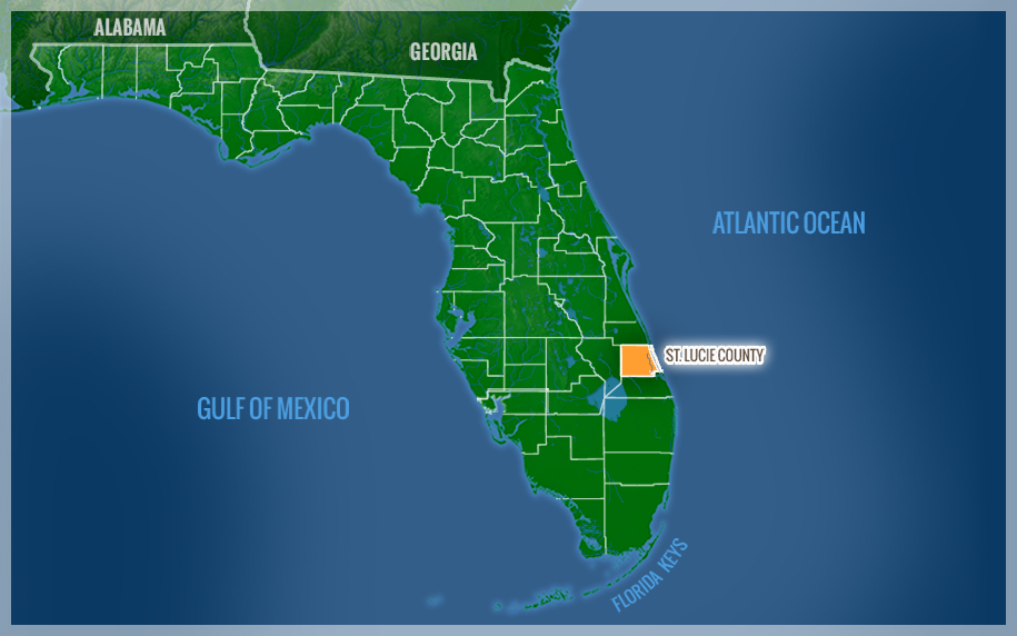
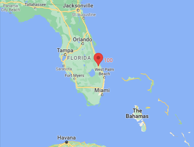
Locating Port St. Lucie on the Florida map requires an understanding of the state’s unique coastal geography. Situated along the southeastern coast of the United States, this city serves as a primary anchor for a region colloquially and geographically known as the Treasure Coast. To pinpoint it precisely, one must look approximately halfway between Miami and Orlando. It occupies a strategic position in St. Lucie County, nestled between the northern boundaries of Palm Beach and the southern reaches of the Space Coast.
The Heart of the Treasure Coast
The Treasure Coast is a region defined by its history of shipwrecks and the subsequent discovery of Spanish gold, but in a modern geographic sense, it is defined by its pristine waterways and expansive conservation lands. Port St. Lucie is the most populous municipality in this region. On a physical map, the city is bounded to the east by the Indian River Lagoon and the Atlantic Ocean, and to the west by the vast agricultural lands and marshes that lead toward Lake Okeechobee.
Unlike many older Florida cities that grew organically around a single port or rail station, Port St. Lucie was a planned community. This is evident on the map by its sprawling residential grid and the presence of the North Fork St. Lucie River, which snakes through the city’s heart, providing a natural landmark that dictates much of the local topography.
Regional Proximity to Major Hubs
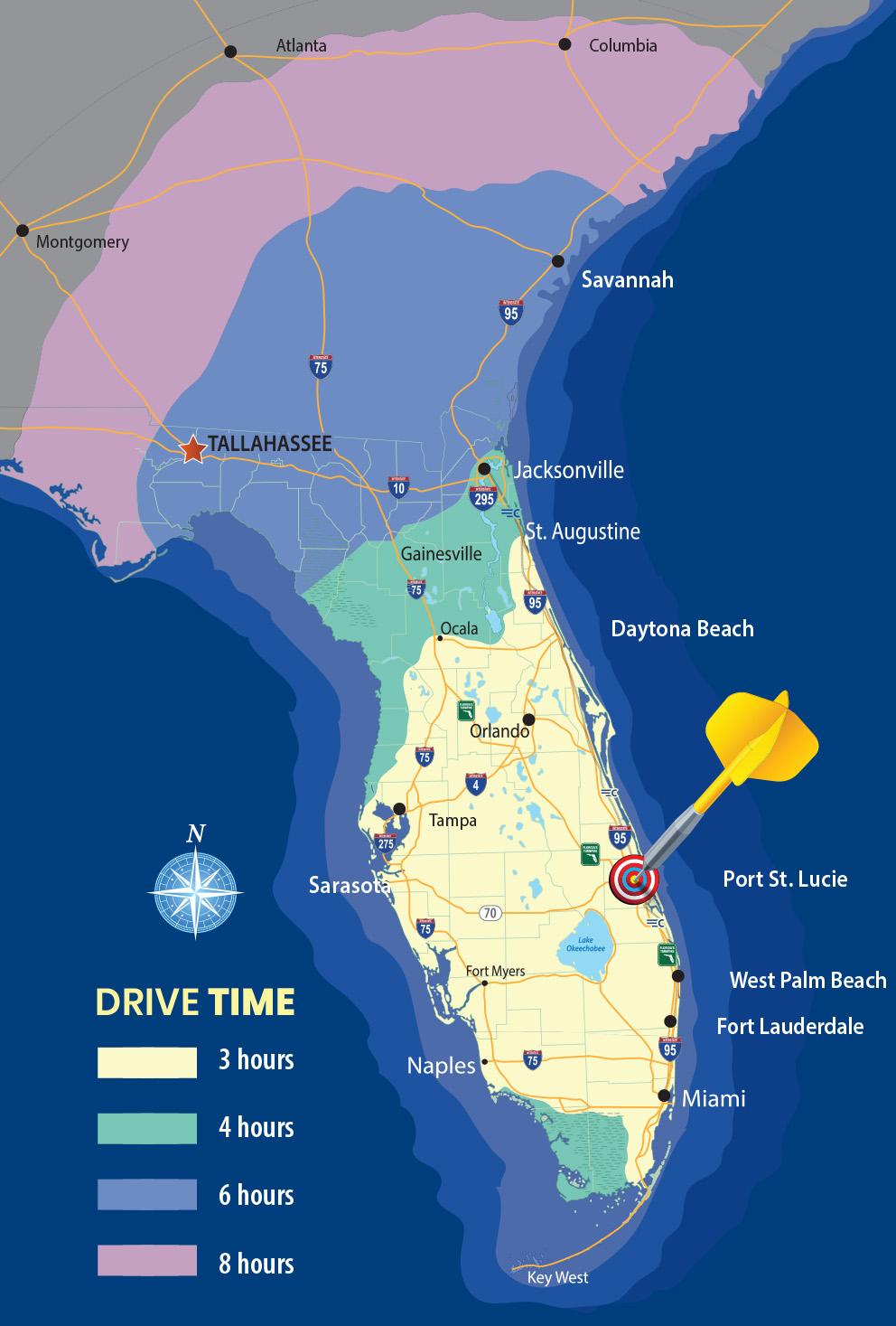
To understand where Port St. Lucie sits in relation to the rest of the state, consider its distance from major metropolitan landmarks. It is located roughly 125 miles southeast of Orlando and about 115 miles north of Miami. Its closest neighbors include Fort Pierce to the north and Stuart to the south. The city’s location is highly accessible via major transportation arteries, including Interstate 95 and the Florida Turnpike, both of which run north-to-south through the city’s western corridors.
Distinctive Natural Landmarks and Ecosystems
The geography of Port St. Lucie is defined by more than just its coordinates. It is home to several significant natural landmarks that serve as vital ecological preserves for South Florida. These sites are not only markers on a map but are the literal foundations of the city’s environmental identity.
Savannas Preserve State Park
One of the most prominent geographic landmarks in the area is the Savannas Preserve State Park. Stretching along the eastern edge of the city, this park represents the largest remaining remnant of Florida east coast savannas. This ecosystem is a unique mix of wet prairies, pine flatwoods, and marshes. On a topographical map, this area is characterized by a high ridge that separates the freshwater savannas from the saltwater Indian River Lagoon. It provides a crucial buffer for the coastline and serves as a landmark for those interested in the prehistoric landscape of the Sunshine State.
The North Fork St. Lucie River
The North Fork St. Lucie River is the city’s most significant aquatic landmark. Unlike the heavily developed coastlines of Fort Lauderdale or Miami, much of the riverbank in Port St. Lucie remains preserved. The river is a designated Florida State Canoe Trail and provides a glimpse into the subtropical wilderness that once dominated the entire region. The river winds through the city, creating deep-water access for residents and serving as a home for manatees, alligators, and various bird species. Its confluence with the South Fork in Stuart eventually leads out to the St. Lucie Inlet.
Oak Hammock Park
For those mapping the city’s interior landmarks, Oak Hammock Park stands as a testament to the native hardwood hammocks that once covered the interior. This landmark offers a stark contrast to the surrounding pine-dominated landscapes. With its ancient oak canopies and proximity to the C-24 Canal, it represents a critical point where the city’s water management systems meet its natural history.
Architectural and Cultural Landmarks
Beyond its natural beauty, Port St. Lucie is defined by significant man-made landmarks that have put the city on the international map. These sites range from world-class sporting facilities to carefully manicured gardens, each serving as a focal point for the community.
The PGA Village
Perhaps the most famous landmark in Port St. Lucie is the PGA Village. Located in the western part of the city, this massive complex is owned and operated by the PGA of America. It features multiple championship golf courses designed by legends such as Tom Fazio and Pete Dye. The PGA Golf Club and the PGA Education Center are major architectural and professional hubs, attracting golfers and professionals from across the globe. On a map, this area signifies the city’s transition from a residential retreat to a premiere destination for sports and industry.
Clover Park
In the northern section of the city lies Clover Park, a major landmark for sports fans. This stadium is the Spring Training home of the New York Mets. For several months of the year, this venue becomes the epicenter of activity in St. Lucie County. The stadium’s presence has anchored the development of the St. Lucie West neighborhood, a master-planned area that includes commercial centers and high-density residential zones, significantly altering the city’s skyline over the last few decades.
Port St. Lucie Botanical Gardens
Located on the banks of the North Fork St. Lucie River, the Port St. Lucie Botanical Gardens serve as a cultural and environmental landmark. This site showcases a variety of gardens, including orchid, rose, and butterfly gardens. Historically, this site was part of a larger estate, and its preservation as a public landmark ensures that the city maintains a green heart amidst its urban expansion. The Port St. Lucie Botanical Gardens represent the intersection of the city’s horticultural heritage and its commitment to community space.
Historical Context and Land Development
The mapping of Port St. Lucie is inextricably linked to the history of land development in mid-20th-century Florida. Understanding where the city is today requires understanding how it was physically carved out of the wilderness.
The General Development Corporation Legacy
In the late 1950s, the General Development Corporation (GDC) began the process of transforming thousands of acres of uninhabited forest and wetlands into what would become Port St. Lucie. The GDC used a massive system of canals and roads to create a grid that is still clearly visible on satellite maps today. This historical development marked the transition of the land from the Spruce Bluff settlement—one of the earliest pioneer communities in the area—into a modern suburban landscape. The remains of the Spruce Bluff site, including an ancient Ais Indian mound, still exist as a historical landmark on the city’s southern edge.
Tradition: A Modern Landmark
A more recent addition to the geographic and cultural landscape is the community of Tradition. Located on the western edge of Port St. Lucie, Tradition is a master-planned “New Urbanist” development. It is easily identifiable by its signature clock tower and town square. Tradition represents the newest chapter in the city’s development, shifting the center of gravity further west toward the Florida Turnpike. This area also hosts the Tradition Medical Center, a major landmark in the regional healthcare landscape.
Evolution of the City Center
For many years, Port St. Lucie lacked a traditional “downtown” area. However, the development of the Port St. Lucie Civic Center—now known as the MIDFLORIDA Event Center—provided the city with a central landmark for governance, culture, and social gathering. Located at the intersection of US Highway 1 and Walton Road, this facility is a key landmark that helps residents and visitors orient themselves within the city’s sprawling layout.
Navigating the Map of Port St. Lucie
When looking at a map of Florida, Port St. Lucie stands out as a bridge between the heavily urbanized corridors of the south and the more relaxed, nature-focused regions of Central Florida. Its geographic placement provides a unique vantage point to explore the state’s varied landscapes.
To the east, the barrier islands like Hutchinson Island offer a direct connection to the Atlantic Ocean, with landmarks like the House of Refuge nearby. To the west, the city borders the rural expanse of the Florida interior, leading toward the vast Everglades ecosystem. This dual identity—part coastal retreat, part inland suburban hub—is what defines its place on the map.
Whether one is identifying the city by its proximity to Jupiter or its relationship with the St. Lucie River, it is clear that Port St. Lucie is a significant and growing landmark in its own right. Its evolution from a vision of the General Development Corporation to a thriving city of over 200,000 residents is a major milestone in the history of Florida land development. Mapping Port St. Lucie is not just about finding a point on a grid; it is about recognizing a complex tapestry of natural preserves, historical sites, and modern architectural achievements.
LifeOutOfTheBox is a participant in the Amazon Services LLC Associates Program, an affiliate advertising program designed to provide a means for sites to earn advertising fees by advertising and linking to Amazon.com. Amazon, the Amazon logo, AmazonSupply, and the AmazonSupply logo are trademarks of Amazon.com, Inc. or its affiliates. As an Amazon Associate we earn affiliate commissions from qualifying purchases.