
The short answer is yes; Hawaii is one of the most seismically active regions in the United States and the entire Pacific Ocean. While many visitors associate the islands primarily with pristine beaches and lush tropical landscapes, the ground beneath these famous landmarks is in a constant state of motion. Understanding the nature of earthquakes in this archipelago requires a deep dive into the geological forces that created the Big Island, Maui, Oahu, Kauai, Molokai, Lanai, Niihau, and Kahoolawe.
Earthquakes in this region are not just occasional anomalies; they are the heartbeat of the islands’ natural history. From the towering heights of Mauna Kea to the fiery depths of Kilauea, seismic activity serves as a reminder that this tropical paradise is a living, breathing volcanic entity. For those interested in the landmarks and natural architecture of the islands, the history of these tremors provides essential context for the dramatic cliffs, deep valleys, and expanding coastlines that define the region.

The Geological Foundations of the Hawaiian Islands
To understand why Hawaii experiences earthquakes, one must first look at the Hawaiian Hotspot. Unlike many other seismic zones, such as the San Andreas Fault, Hawaii is not located at the boundary of tectonic plates. Instead, it sits in the middle of the Pacific Plate. The islands were formed—and continue to be formed—by a plume of magma rising from deep within the mantle. As the tectonic plate moves slowly toward the northwest, the hotspot remains stationary, creating a chain of volcanic landmarks over millions of years.
Volcanic Earthquakes vs. Tectonic Earthquakes
In the context of the islands’ natural landmarks, there are two primary types of earthquakes. The most frequent are volcanic earthquakes. These occur when magma moves within the subterranean plumbing systems of active volcanoes like Mauna Loa and Kilauea. As the molten rock forces its way through the crust, it fractures the surrounding stone, resulting in thousands of micro-quakes that are often only detectable by sensitive instruments at the Hawaiian Volcano Observatory.
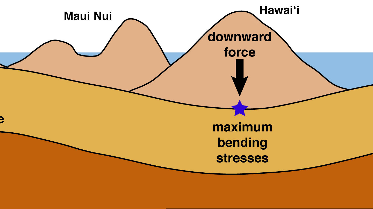
The second type consists of tectonic earthquakes caused by the sheer weight of the islands. As volcanoes grow, they add massive amounts of basaltic rock to the Pacific Plate. This enormous weight causes the plate to bend and flex, leading to “lithospheric flexure” earthquakes. These can be significantly more powerful than volcanic tremors and are felt across multiple islands, sometimes affecting landmarks as far away as Honolulu or the North Shore of Oahu.
The Role of Earthquakes in Shaping the Landscape
Seismic activity is a master architect of the islands’ nature. The dramatic sea cliffs of the Hamakua Coast and the sheer drops of the Na Pali Coast on Kauai were formed, in part, by massive prehistoric landslides triggered by earthquakes. These “slumps” occur when the unstable flanks of a volcano collapse into the ocean, fundamentally altering the geography of the landmark and sending shockwaves through the surrounding sea.
Seismic Activity and Volcanic Landmarks
The most famous natural landmarks on the Big Island are inextricably linked to seismic activity. Hawaii Volcanoes National Park, a UNESCO World Heritage Site, serves as a primary laboratory for observing these forces. Here, earthquakes are not feared as much as they are studied as precursors to the islands’ most spectacular shows: volcanic eruptions.
Kilauea and the 2018 Seismic Transformation
The most significant recent seismic event occurred in 2018 during the eruption of Kilauea. For months, the Puna district was rocked by thousands of earthquakes daily. One of the most dramatic impacts on a landmark was the collapse of the Halemaumau Crater. As the magma reservoir beneath the summit drained toward the lower East Rift Zone, the floor of the crater dropped hundreds of feet. This seismic collapse was so powerful that it registered as a magnitude 5.3 event nearly every day for weeks, forever changing the skyline of the park.
Visitors to Hawaii Volcanoes National Park today can see the scars of this activity. The massive fractures in the earth near Jaggar Museum and the closed sections of Crater Rim Drive stand as monuments to the power of these tremors. The seismic events of 2018 also destroyed the village of Kalapana decades prior and reshaped the coastline, proving that in Hawaii, the earth is never finished with its work.
Mauna Loa: The Sleeping Giant
While Kilauea is the most active, Mauna Loa is the most massive. As the world’s largest subaerial volcano, its seismic profile is closely watched. When Mauna Loa erupted in late 2022, it was preceded by a significant increase in earthquake frequency. These tremors served as a warning to the residents of Kona and Hilo. The earthquakes associated with Mauna Loa tend to be deep-seated, reflecting the enormous pressure required to move magma through such a gargantuan structure.
Historical Earthquakes and Their Impact on the Built Environment
While the focus is often on nature, the history of Hawaii includes seismic events that have left a lasting mark on its historical landmarks and cities. The most powerful earthquake in recorded history for the islands occurred in 1868. Located beneath the southern flank of Mauna Loa, this magnitude 7.9 event caused widespread destruction from Ka’u to Hilo.
The Reconstruction of Hilo
Hilo, the largest city on the Big Island, has a unique relationship with seismic activity. Because it sits at the head of a funnel-shaped bay, it is particularly vulnerable to tsunamis—often the most dangerous byproduct of earthquakes. Historic landmarks in Hilo, such as the Lyman Museum, have survived various tremors, but much of the city’s waterfront architecture was redesigned or moved following the devastating tsunamis of 1946 and 1960.
The 1946 tsunami was triggered by an earthquake in the Aleutian Islands near Alaska, highlighting that Hawaii is affected not only by local quakes but by “teleseismic” events from across the Pacific Ocean. Today, landmarks like Laupahoehoe Point serve as memorials to the seismic history that has shaped the lives of the Hawaiian people.
Landmarks of Oahu and the Neighbor Islands
Even islands that are no longer volcanically active, such as Oahu, are not immune to seismic events. Famous landmarks like Diamond Head and Punchbowl Crater are the results of a much later “rejuvenation” phase of volcanism, which involved its own set of ancient earthquakes. In 2006, a magnitude 6.7 earthquake centered off the coast of Kiholo Bay on the Big Island was felt strongly in Honolulu. This event caused damage to the historic Hulihee Palace in Kailua-Kona and shook the high-rises of Waikiki, proving that the geological reach of the Hawaiian Hotspot extends far beyond the active craters.
Exploring the Dynamic Nature of Hawaii’s National Parks
For those who travel to see the natural wonders of the United States, the seismic nature of Hawaii adds a layer of awe to the experience. Landmarks like Haleakala on Maui may appear silent, but they are part of a massive volcanic system that is still considered active. Haleakala National Park contains cinder cones and lava flows that are geologically young, and the occasional earthquake in the Alenuihaha Channel reminds us that the mountain is still settling.
Safety and the Pacific Tsunami Warning Center
Because earthquakes are a reality of life in the islands, the Pacific Tsunami Warning Center (PTWC), located on Oahu, is one of the most important administrative landmarks in the region. It monitors seismic activity across the entire Pacific Basin, protecting landmarks from Japan to Chile. Visitors to famous beaches like Hanalei Bay or Makena Beach will notice tsunami evacuation signs—a necessary part of the infrastructure in a land defined by seismic shifts.
The United States Geological Survey and Modern Monitoring
The United States Geological Survey (USGS) maintains a vast network of seismometers across all the islands. This technological layer has become a part of the modern history of Hawaii. By tracking every rumble beneath Mauna Kea or the offshore volcano Loihi (soon to be the next Hawaiian island, known as Kama’ehuakanaloa), scientists can predict eruptions and protect the millions of people who visit these landmarks every year.

Conclusion: A Landscape in Constant Motion
Hawaii does indeed have earthquakes, and they are a fundamental part of its identity. These seismic events are the tools that carve the valleys, build the mountains, and occasionally reclaim the land. For anyone admiring the beauty of Iolani Palace, the heights of Mauna Loa, or the depths of Waimea Canyon, it is important to remember that these landmarks are not static. They are the results of a dynamic process where the earth’s internal heat meets the cool waters of the Pacific Ocean, a process punctuated by the frequent and fascinating occurrences of earthquakes. To experience Hawaii is to experience a landscape that is still being born, one tremor at a time.
LifeOutOfTheBox is a participant in the Amazon Services LLC Associates Program, an affiliate advertising program designed to provide a means for sites to earn advertising fees by advertising and linking to Amazon.com. Amazon, the Amazon logo, AmazonSupply, and the AmazonSupply logo are trademarks of Amazon.com, Inc. or its affiliates. As an Amazon Associate we earn affiliate commissions from qualifying purchases.