
The silhouette of Diamond Head is perhaps the most recognizable natural landmark in the Pacific Ocean. As a defining feature of the Honolulu skyline, this massive tuff cone serves as a sentinel over the southern coast of Oahu. While many recognize its profile from postcards and cinematic backdrops, its precise location, geological complexity, and historical depth offer a rich narrative that defines the identity of Hawaii.
The Geographic Identity and Location of a Hawaiian Icon
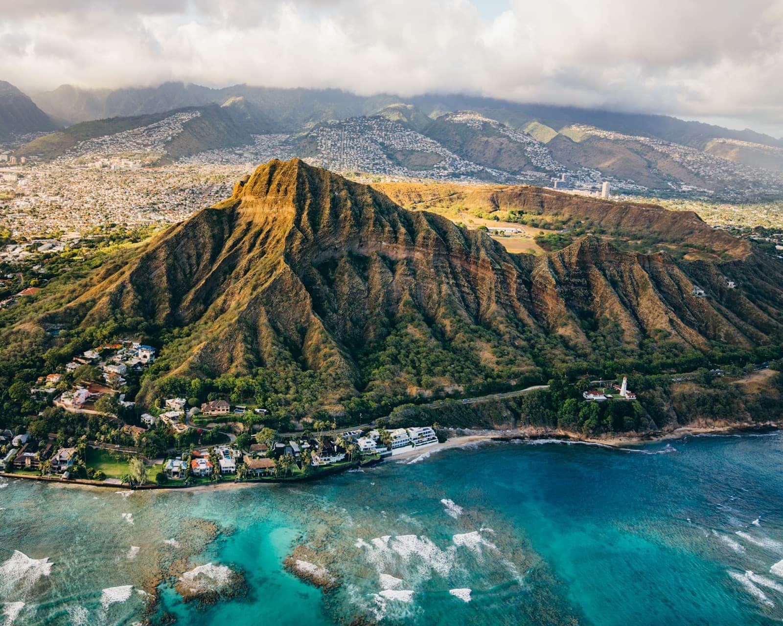
To understand where Diamond Head is located, one must look to the southeastern edge of the Waikiki coastline. It sits as a prominent headland, marking the eastern end of the Mamala Bay. Geographically, the landmark is situated at approximately 21.26° N latitude and 157.81° W longitude. It occupies a strategic position that bridges the gap between the bustling urban center of Honolulu and the quieter residential stretches of Kahala.
Positioning Within the Island of Oahu
Oahu, often called the “Gathering Place,” is characterized by two major mountain ranges: the Ko’olau Range in the east and the Waianae Range in the west. Diamond Head is not part of these primary shield volcanoes but is rather a secondary volcanic vent. It is located on the leeward side of the island, meaning it sits in the rain shadow of the Ko’olau Range. This specific positioning results in a semi-arid environment within the crater, starkly contrasting with the lush, tropical rainforests found just a few miles inland.
Proximity to Waikiki and Kapiolani Park
For most visitors, the landmark is accessed through the Diamond Head State Monument. It is located adjacent to Kapiolani Park, the oldest and largest public park in Hawaii. The crater’s proximity to the primary tourism hub of Waikiki makes it an inescapable part of the local geography. From the shores of Waikiki Beach, the crater looms to the east, providing a dramatic termination to the white sand crescent of the coast.
The Geological Origins and Natural Significance
The location of Diamond Head is the result of a violent and specific geological event known as the Honolulu Volcanic Series. While the main volcanoes that formed Oahu went dormant over two million years ago, a series of smaller eruptions occurred much later, creating various landmarks across the southeastern coast.
The Honolulu Volcanic Series
This series of eruptions began approximately 300,000 to 500,000 years ago. Unlike the slow-moving lava flows that built the Big Island, the eruptions that created Diamond Head were phreatomagmatic. This occurs when rising magma hits the water table or the ocean, resulting in explosive steam-driven eruptions. This process created several vents, including Punchbowl Crater, Hanauma Bay, and Koko Head.
Formations and Topography of the Tuff Cone
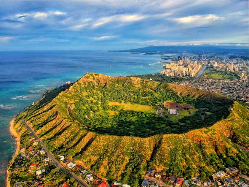
The crater is technically a “tuff cone,” composed of volcanic ash that has hardened into rock over millennia. Its saucer-like shape is roughly circular, with the highest point on the southwestern rim reaching 761 feet. The location’s unique topography—a hollowed-out interior surrounded by steep, jagged ridges—made it a natural fortress and a focal point for ecological study. In 1968, Diamond Head was declared a National Natural Landmark, ensuring the preservation of its distinctive geological features.
Historical Evolution: From Le’ahi to a Military Stronghold
The location of the crater has held immense value for different populations throughout history. Before it was known by its British name, it was deeply integrated into the cultural and spiritual life of the Polynesian settlers who first arrived in the Hawaiian Islands.
Cultural Roots and the Name Le’ahi
Native Hawaiians named the crater Le’ahi. The name is often translated as “brow of the ahi,” referring to the ahi tuna. When viewed from the summit of the Ko’olau Range, the profile of the crater resembles the dorsal fin and forehead of the fish. Another interpretation links the name to the fires (ahi) that were lit on the summit to guide canoes navigating the coast.
The crater is also featured in the legend of Hi’iaka, the sister of the fire goddess Pele. According to oral tradition, Hi’iaka compared the shape of the crater to the forehead of the ahi fish while she was traveling across the islands. This indigenous perspective emphasizes the landmark as a point of navigation and cultural storytelling rather than just a physical barrier.

The Origin of the Name “Diamond Head”
The transition to the name Diamond Head occurred in the 19th century. British sailors, exploring the coastline, discovered calcite crystals embedded in the volcanic rock on the slopes of the crater. Mistaking these sparkling minerals for actual diamonds, they named the site Diamond Head. Although the “diamonds” turned out to be worthless volcanic glass, the name persisted and eventually replaced Le’ahi in common international parlance.
Military Defense and Fort Ruger
In the early 20th century, the United States recognized the strategic military value of the crater’s location. Because it offered an unobstructed view of the entire southern coast of Oahu, it was an ideal spot for coastal defense. In 1904, the crater was purchased by the Federal Government for military use.
This led to the establishment of Fort Ruger, the first United States military reservation in Hawaii. Engineers carved tunnels through the crater walls and built observation posts and bunkers along the rim. The Birkhimer Tunnel was created to provide access for vehicles and equipment into the crater floor. For decades, the location served as a vital node in the defense of Pearl Harbor and the Pacific fleet.
Architectural and Structural Features of the Monument
While Diamond Head is a natural landmark, much of its interior and summit architecture is man-made, reflecting the ingenuity of the U.S. Army Corps of Engineers during the early 1900s.
The 1911 Trail and the Tunnel System
The trail that leads to the summit was constructed in 1911 specifically to facilitate the movement of coastal defense equipment. It is an architectural feat that navigates the steep, crumbly tuff of the crater walls. The trail includes a series of switchbacks, a 225-foot tunnel, and a set of incredibly steep stairs—99 steps in one section and 76 in another—that lead directly into the old fire control stations.
These fire control stations were designed to coordinate the aiming of heavy artillery located at Fort DeRussy and Fort Barrett. The structures are built into the very rock of the summit, camouflaged from the sea to ensure they remained invisible to enemy ships.
Observation Posts and Coastal Defense
At the summit, visitors can still see the tiered observation levels. These concrete structures were once filled with sophisticated range-finding equipment and telescopes. The architecture here is purely functional, yet it offers a fascinating glimpse into the era of coastal artillery. From this vantage point, soldiers could track ships miles out at sea, long before the advent of modern radar systems.
Exploring the Diamond Head State Monument Today
Today, the location is managed as the Diamond Head State Monument by the Hawaii Department of Land and Natural Resources. It remains one of the most visited sites in the state, serving as a primary destination for those interested in the intersection of natural history and military architecture.
The Summit Experience and Panoramic Views
The hike from the crater floor to the summit provides a unique perspective on the landscape of Oahu. At the top, the 360-degree view is unparalleled. To the west, the high-rises of Waikiki and Downtown Honolulu dominate the view, with the Ewa Plain and Waianae Mountains visible in the distance. To the east, hikers can see the jagged coastline leading toward Hanauma Bay and the volcanic remains of Koko Head. Directly below, the Diamond Head Lighthouse stands as a historic marker for maritime traffic.
Conservation Efforts and Preservation
As a National Natural Landmark, the crater is subject to ongoing conservation efforts. The environment within the crater is harsh; the high heat and lack of rainfall mean that only the hardiest plants can survive. Native species like the Wiliwili tree and various endemic grasses are part of the restoration efforts to keep the ecosystem balanced against invasive species like Kiawe.
Preservation also extends to the structural integrity of the trail and the historic military bunkers. Because the tuff rock is prone to erosion, the State of Hawaii frequently conducts maintenance to ensure the safety of the path while protecting the sensitive geological features.
The enduring appeal of Diamond Head lies in its multifaceted nature. It is not merely a mountain or a park; it is a geological anomaly, a military relic, and a cultural touchstone. Its location on the edge of the Pacific Ocean continues to inspire and ground the island of Oahu, serving as a permanent reminder of the volcanic forces that shaped the Hawaiian Islands.
LifeOutOfTheBox is a participant in the Amazon Services LLC Associates Program, an affiliate advertising program designed to provide a means for sites to earn advertising fees by advertising and linking to Amazon.com. Amazon, the Amazon logo, AmazonSupply, and the AmazonSupply logo are trademarks of Amazon.com, Inc. or its affiliates. As an Amazon Associate we earn affiliate commissions from qualifying purchases.