
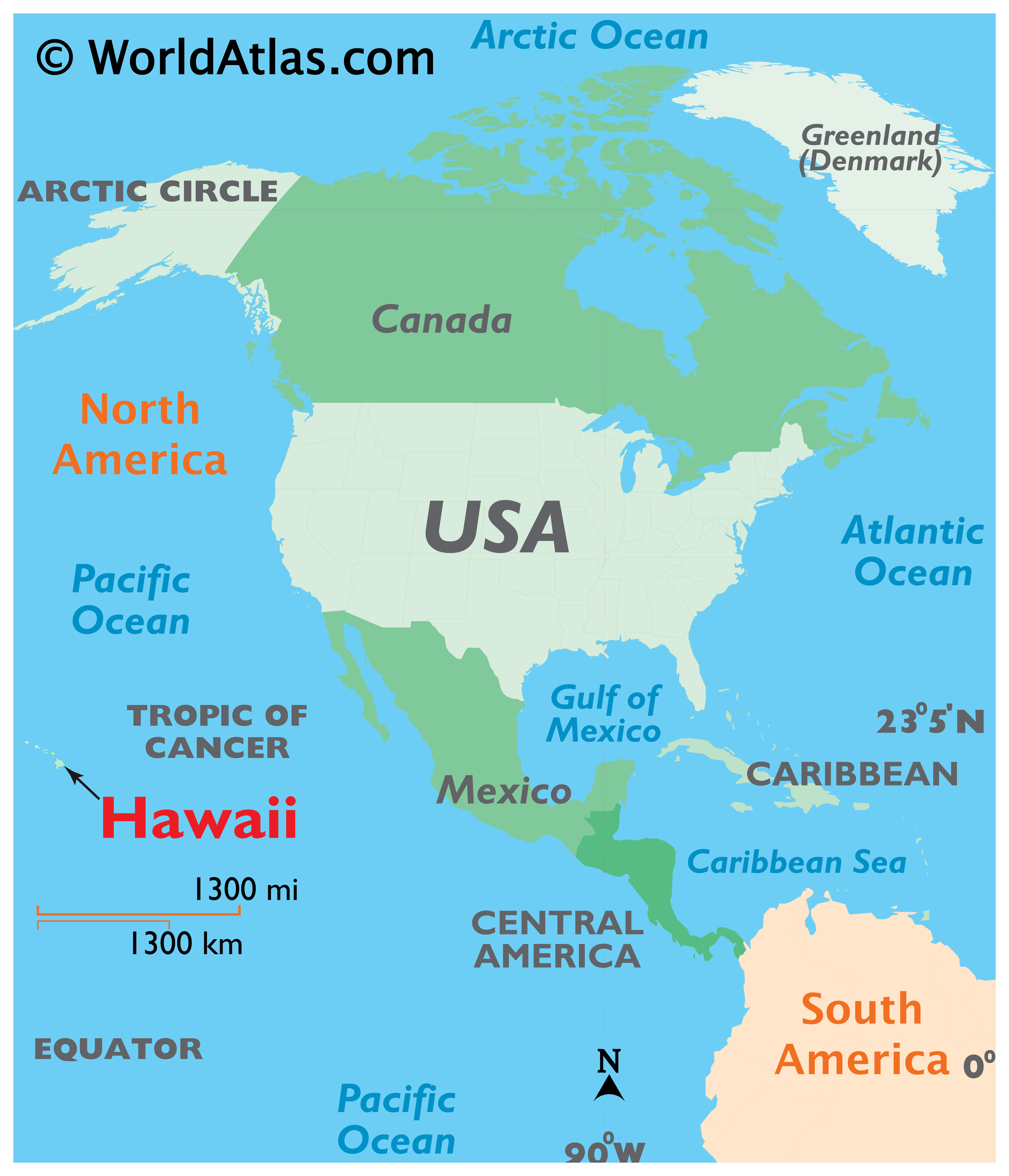
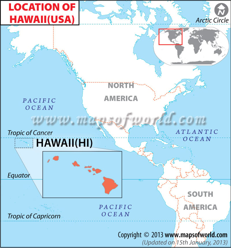
Understanding the location of Hawaii requires a shift in perspective from continental thinking to oceanic exploration. Situated in the vast expanse of the Pacific Ocean, this archipelago represents one of the most isolated yet culturally significant landmarks on the globe. It is the only state in the United States that is not part of the North America continent, existing instead as a string of volcanic jewels roughly 2,400 miles from California and over 3,800 miles from Japan. This geographical isolation has defined its history, its biological diversity, and its status as a premier global destination.

The Geographic Heart of the Pacific
When looking at a world map, Hawaii appears as a tiny speck in the center of the North Pacific Ocean. Specifically, the islands are located between 18° and 22° north latitude and 154° and 160° west longitude. This positioning places the islands just south of the Tropic of Cancer, ensuring a tropical climate that has become synonymous with the region’s identity.
The Polynesian Triangle
Hawaii serves as the northern apex of the Polynesian Triangle, a massive region of the Pacific Ocean with New Zealand to the southwest and Easter Island to the southeast. This positioning is not merely a geometric curiosity; it explains the migratory patterns of the early Polynesia voyagers who used celestial navigation to traverse thousands of miles of open water. Landmarks like the Star Lookout points on various islands still honor this legacy of wayfinding.
Proximity to Global Hubs
While Hawaii is famously isolated, its location makes it a strategic “crossroads of the Pacific.” It sits roughly equidistant between the western coast of the United States and the eastern coast of Asia. This has made Honolulu, the capital city located on the island of Oahu, a vital stopover for maritime trade and aviation. The city’s landmarks, such as the Aloha Tower, were historically the first signs of land for travelers crossing the deep blue.
The Main Eight Islands as Natural Landmarks
The Hawaii archipelago consists of 137 islands, atolls, and shoals, but the world generally recognizes the eight “main” islands that form the southeastern end of the chain. Each of these islands is a distinct geological landmark with its own personality and topographical features.
Oahu: The Gathering Place
Oahu is the most populous island and home to the iconic Diamond Head crater. This volcanic tuff cone is perhaps the most photographed natural landmark in the Pacific Ocean. Below its slopes lies Waikiki Beach, a world-renowned stretch of coastline that serves as a landmark for global tourism. Oahu also hosts the historic Pearl Harbor, a site of immense national significance where the USS Arizona Memorial stands as a somber architectural tribute to the events of 1941.
Maui: The Valley Isle
To the southeast of Oahu lies Maui, famous for the massive shield volcano Haleakala. The Haleakala National Park is a landmark of biodiversity, featuring a crater so large it could fit the entire island of Manhattan inside. On the eastern shore, the Road to Hana winds through lush rainforests, leading to natural landmarks like the Seven Sacred Pools at Oheo Gulch.
Kauai: The Garden Isle
The oldest of the main islands, Kauai, is home to some of the most dramatic natural architecture in the world. The Na Pali Coast features emerald-green cliffs that rise 4,000 feet directly from the sea. Inland, the Waimea Canyon, often called the “Grand Canyon of the Pacific,” offers a stark contrast of deep red soil and vibrant greenery, marking it as a premier geological landmark of the United States.
The Big Island: Hawaii
The Island of Hawaii, or the Big Island, is the youngest and largest in the chain. It is a place of constant creation, dominated by the Volcanoes National Park. Here, Kilauea and Mauna Loa continue to shape the map, literally adding new land to the island. Mauna Kea, a dormant volcano, is the tallest mountain in the world when measured from its base on the ocean floor, making it a landmark of global scientific importance for astronomers.
Geological Wonders and Volcanic Origins
The reason Hawaii exists on the map at all is due to a “hotspot” in the Earth‘s mantle. Unlike most volcanic activity that occurs at the boundaries of tectonic plates, the Hawaii Hotspot is located in the middle of the Pacific Plate.
The Movement of the Pacific Plate
As the Pacific Plate moves slowly toward the northwest (at a rate of about 3 to 4 inches per year), the stationary hotspot beneath it punches through the crust to create a series of islands. This is why Kauai in the northwest is the oldest and most eroded, while the Big Island in the southeast is the youngest and still growing. This geological conveyor belt has created a trail of undersea mountains known as the Hawaiian-Emperor Seamount Chain, which stretches all the way to the Aleutian Trench near Russia.
Volcanic Landscapes as Landmarks
The volcanoes themselves are the primary landmarks of the state. Mauna Loa is the world’s largest subaerial volcano, covering half of the Big Island. Its massive presence influences the weather patterns for the entire archipelago, creating “rain shadows” that result in the dry, sunny conditions of the Kona coast and the lush, rainy environment of Hilo. These natural forces have crafted landmarks like the Panaewa Rainforest Zoo and the black sand beaches of Punaluu.
Historical Context and the Mapping of the Islands
Long before Hawaii appeared on Western maps, it was a thriving society with its own complex understanding of geography. The first settlers, likely from the Marquesas Islands and later Tahiti, navigated by the stars, the flight of birds, and the patterns of ocean swells.
European “Discovery” and Mapping
The islands first appeared on European maps following the arrival of Captain James Cook in 1778. Sailing for the British Empire aboard the HMS Resolution, Captain James Cook named them the Sandwich Islands in honor of the Earl of Sandwich. A historical landmark commemorating his arrival and subsequent death stands at Kealakekua Bay on the Big Island.
Architectural Landmarks of the Monarchy
As Hawaii transitioned from a collection of chiefdoms to a unified kingdom under King Kamehameha I, the mapping of the islands became more formalized. In Honolulu, the Iolani Palace stands as the only royal palace on United States soil. This landmark of Hawaiian Renaissance architecture serves as a reminder of the sovereign nation that existed before the islands were annexed by the United States in 1898. Other historical landmarks include the Kawaiahao Church, often called the Westminster Abbey of the Pacific.
Iconic Natural and Cultural Landmarks Across the Archipelago
To truly place Hawaii on the map, one must look at the landmarks that define its soul. These sites are not just pins on a GPS; they are the physical manifestations of the islands’ history and ecology.
Puuhonua o Honaunau National Historical Park
Located on the Kona coast, Puuhonua o Honaunau National Historical Park is a landmark of ancient Hawaii justice and culture. Known as the “Place of Refuge,” this site features massive stone walls and wooden Tiki statues that have stood for centuries. It provides a window into the pre-contact era when the islands were mapped according to the Ahupuaa system—a land division method that ran from the mountains to the sea.
The North Shore of Oahu
As a landmark for the global surfing community, the North Shore of Oahu becomes the center of the world every winter. Famous breaks like Banzai Pipeline and Waimea Bay are seasonal landmarks that draw thousands of visitors. The geography of the ocean floor here creates some of the largest and most dangerous waves on the planet, making it a critical point on the map for extreme sports.
Molokai’s Sea Cliffs
On the island of Molokai, the northern coast features the Kalaupapa Peninsula, which is home to the highest sea cliffs in the world, dropping nearly 3,300 feet into the Pacific Ocean. This area is also a historical landmark, having served as an isolation settlement for people with Hansen’s Disease. Today, the Kalaupapa National Historical Park preserves the memory of those who lived there, including Saint Damien and Saint Marianne Cope.
Mount Waialeale
On Kauai, Mount Waialeale is frequently cited as one of the wettest spots on Earth. The summit is a natural landmark characterized by the “Wall of Tears,” where dozens of waterfalls cascade down the verdant cliffs. This extreme rainfall is a direct result of the island’s location in the Trade Winds belt of the Pacific Ocean, illustrating how geography dictates the very nature of the Hawaiian landscape.
The Midway Atoll
Though far to the northwest of the main islands, the Midway Atoll is part of the Hawaiian archipelago and serves as a vital landmark of World War II history. The Battle of Midway was a turning point in the Pacific Theater, and today the atoll is part of the Papahanaumokuakea Marine National Monument, one of the largest marine conservation areas in the world. This landmark status protects millions of seabirds and diverse marine life, ensuring that even the most remote corners of Hawaii remain preserved for future generations.
LifeOutOfTheBox is a participant in the Amazon Services LLC Associates Program, an affiliate advertising program designed to provide a means for sites to earn advertising fees by advertising and linking to Amazon.com. Amazon, the Amazon logo, AmazonSupply, and the AmazonSupply logo are trademarks of Amazon.com, Inc. or its affiliates. As an Amazon Associate we earn affiliate commissions from qualifying purchases.