
The allure of Idaho is undeniable. Vast wilderness, towering mountains, pristine lakes, and a spirit of rugged independence draw adventurers and nature lovers alike. However, the grandeur of the Gem State can, at times, be dramatically altered by the presence of wildfires. For those planning a visit or residing within its borders, understanding the current wildfire situation is not just a matter of curiosity but a crucial aspect of responsible travel and local engagement. This guide aims to shed light on where to find information about active wildfires in Idaho, helping you navigate its landscapes safely and informedly.

Understanding Wildfire Dynamics in Idaho
Idaho’s diverse topography and climate create a complex environment where wildfires can ignite and spread. From the arid plains of southwestern Idaho to the dense forests of the panhandle, different regions present unique wildfire risks. The primary drivers behind these fires include lightning strikes in remote areas, human carelessness, and, in some instances, prescribed burns that may escape containment.
Geographic Factors and Fire Susceptibility
The state’s geography plays a significant role in wildfire behavior.
Vast Wilderness Areas
Idaho boasts immense tracts of undeveloped land, including national forests like the Boise National Forest, Payette National Forest, and Salmon-Challis National Forest. These areas, while spectacular for hiking, camping, and exploring, are often remote, making fire detection and suppression challenging. The sheer scale of these forests means that fires can smolder for days or weeks before being fully reported or controlled.
Climate and Fuel Load
The climate of Idaho oscillates between hot, dry summers and cold, snowy winters. The dry periods, particularly from late spring through early fall, create conditions ripe for ignition. Accumulations of dry vegetation, dead trees, and undergrowth act as fuel, providing the necessary combustible material for fires. Drought conditions exacerbate this, turning even a small spark into a potentially significant blaze. Different ecosystems within Idaho also have varying fuel types and densities, influencing how fires start and spread. For instance, grasslands in the south may burn differently than the dense coniferous forests in the north.
Ignition Sources
- Lightning: Natural lightning storms are a common cause of wildfires in the more remote and mountainous regions of Idaho. These fires, often referred to as “20-man fires” in firefighter jargon due to their initial difficulty in reaching, can be challenging to combat.
- Human Activity: Campfires left unattended, discarded cigarettes, sparks from vehicles or equipment, and fireworks are unfortunately frequent human-caused ignition sources. Recognizing and mitigating these risks is paramount for visitors and residents alike.
Locating Active Wildfire Information
Staying informed about active wildfires in Idaho is essential for planning outdoor activities, ensuring safety, and understanding potential travel disruptions. Several reliable sources provide up-to-date information.
Official Government Resources
Government agencies are the primary custodians of wildfire data. Their websites and platforms are designed to offer comprehensive and accurate information.
National Interagency Fire Center (NIFC)
The National Interagency Fire Center (NIFC), located in Boise, Idaho, serves as the national coordinating center for wildfire suppression. Their website, nifc.gov, is a vital resource for national and regional fire information.
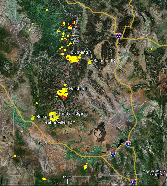
- Fire Map: NIFC often provides interactive fire maps that display the location, size, and status of significant wildfires across the United States, including Idaho. These maps are invaluable for a visual understanding of the wildfire landscape.
- Daily Situation Reports: NIFC publishes daily situation reports detailing acres burned, containment levels, and new incidents. These reports are highly detailed and geared towards a professional audience but offer a thorough overview.
InciWeb
InciWeb is an interagency all-risk incident information management system. It is the primary platform for sharing detailed information about large incidents, including wildfires.
- Incident Details: For each major wildfire, InciWeb provides detailed information such as fire name, location, cause, size, containment percentage, personnel assigned, and management objectives. It also includes maps, photos, and public meeting information. You can access InciWeb at inciweb.wildfire.gov.
- Filtering by State: Users can filter incidents by state, allowing for focused searches on Idaho wildfires.
Bureau of Land Management (BLM) and U.S. Forest Service (USFS)
The Bureau of Land Management and the U.S. Forest Service manage vast amounts of land in Idaho and are directly involved in wildfire management. Their regional and local offices often have dedicated pages on their websites with specific information about fires affecting their managed lands.
- Regional Websites: Exploring the websites of the BLM Idaho State Office and the various USFS National Forests in Idaho can provide localized updates, area closures, and fire restrictions.
State-Specific Resources
Idaho also has state-level resources dedicated to fire management and public safety.
Idaho Department of Lands (IDL)
The Idaho Department of Lands is responsible for managing state-owned forest and endowment lands, as well as providing fire protection for those lands and other private forest lands.
- Fire Status Map: IDL often provides a fire status map specifically for the areas under its jurisdiction, complementing the national resources.
- Fire Prevention and Restrictions: They are also a key source for information on fire restrictions, such as burn bans, which are crucial for residents and visitors.
Idaho Fire Info
A valuable and consolidated resource is the Idaho Fire Info website. This site aggregates information from various agencies to provide a user-friendly overview of the wildfire situation in Idaho.
- Interactive Map: Similar to national resources, it features an interactive map that displays active fires, their status, and key details.
- News and Updates: This platform often shares press releases, public advisories, and important news related to wildfires in the state.
Local and Emergency Alert Systems

Beyond national and state websites, local authorities and emergency services play a critical role in disseminating information.
County Emergency Management
Individual counties in Idaho often have their own emergency management agencies. These agencies are vital for communicating local impacts, evacuation orders, and road closures that might not be immediately apparent on broader platforms. Checking the websites or social media of counties you plan to visit or live near is highly recommended.
Wireless Emergency Alerts (WEA)
During significant wildfire events, emergency management agencies can utilize Wireless Emergency Alerts (WEA) to send critical information directly to mobile phones in affected areas. This system is designed for immediate notification of hazards like evacuation orders.
Planning Your Adventures Amidst Wildfire Season
Wildfire season in Idaho typically runs from late spring through fall, with the peak often occurring in July and August. However, the exact timing and severity can vary significantly year to year based on weather patterns and fuel conditions. Understanding this seasonal context is key to responsible planning.
Checking Before You Go
- Pre-Trip Research: Before embarking on any trip, especially one involving outdoor activities, always check the official wildfire information sources mentioned above. A quick search for “Idaho wildfires” should lead you to these vital resources.
- Destination Specifics: If you are heading to a particular national forest or wilderness area, check the website for that specific entity. For instance, if your destination is the Sawtooth National Recreation Area, look for updates from the USFS Sawtooth National Forest.
Understanding Fire Restrictions and Closures
Wildfires are not the only concern; fire restrictions and area closures are direct consequences of dry conditions and fire activity.
Burn Bans and Red Flag Warnings
- Burn Bans: Local authorities and state agencies issue burn bans to prohibit outdoor burning, including campfires and fireworks, when fire danger is high. Adhering to these bans is crucial for preventing new ignitions.
- Red Flag Warnings: These are issued by the National Weather Service to alert land managers and the public to critical fire weather conditions that are expected to occur within the next 24 to 48 hours. They signify an increased risk of rapid fire spread.
Area Closures
In response to active fires or extremely high fire danger, roads, trails, and entire recreational areas may be closed to the public. These closures are implemented for safety and to allow firefighting efforts to proceed unimpeded. Always heed closure signs and official directives.
Essential Preparedness
- Fire Safety: If you are camping or engaging in outdoor activities, practice extreme caution. Ensure campfires are fully extinguished, never leave them unattended, and be aware of local fire restrictions.
- Travel Alerts: For road trips, check for potential delays or detours due to smoke or fire suppression activities. State Department of Transportation websites often provide real-time traffic information.
- Communication: Ensure you have a way to receive alerts, even in remote areas. Consider carrying a satellite communication device if traveling far from cell service.
The Impact of Wildfires on Idaho’s Tourism and Lifestyle
Wildfires are more than just an environmental concern; they significantly impact Idaho’s tourism and the lifestyle of its residents. The majestic landscapes that draw visitors can be temporarily obscured by smoke or rendered inaccessible due to closures.
Smoke and Air Quality
One of the most pervasive impacts of wildfires, even those far from your immediate location, is smoke. Smoke plumes can travel hundreds of miles, degrading air quality significantly.
- Health Concerns: Poor air quality poses health risks, particularly for those with respiratory conditions. It can lead to canceled outdoor events and reduced visibility, impacting scenic drives and hiking experiences.
- Visual Impact: The thick haze can detract from the stunning vistas that Idaho is known for, impacting the aesthetic appeal for tourists.
Economic Ramifications
- Tourism Downturn: In areas directly affected by large fires, tourism can see a sharp decline. Campgrounds, hotels, restaurants, and outdoor recreation businesses may experience significant losses.
- Suppression Costs: The financial cost of fighting wildfires is astronomical, diverting resources that could otherwise be used for other public services or infrastructure improvements.
Community Resilience and Adaptation
Despite the challenges, Idaho communities have developed a resilience to wildfire events.
- Local Awareness: Residents and businesses often have a keen understanding of fire season and develop contingency plans.
- Firewise Programs: Many communities participate in Firewise USA® initiatives, which empower residents to take action to reduce wildfire risk in their neighborhoods.
- Adaptable Tourism: The tourism sector often adapts by promoting activities in unaffected areas or focusing on indoor attractions when smoke is prevalent.
Staying Informed: A Continuous Necessity
The question “Where are the wildfires in Idaho?” is not a static one. Wildfire situations are dynamic and can change rapidly. Therefore, staying informed is not a one-time task but an ongoing commitment for anyone interacting with the state’s natural environment.
The Importance of Reliable Sources
In an age of readily available information, it is crucial to rely on credible sources for wildfire updates. Official government websites and established emergency alert systems are your best allies. Avoid relying on unverified social media posts or rumors, which can often be inaccurate or outdated.
Long-Term Outlook and Climate Change
While this article focuses on current wildfire locations, it is important to acknowledge the broader context. Experts suggest that climate change is contributing to longer and more intense wildfire seasons globally, and Idaho is not immune. Understanding this trend can help foster a greater appreciation for fire prevention and responsible land stewardship.
Conclusion
Idaho’s wildlands are a treasure, offering unparalleled opportunities for exploration and recreation. By understanding where to find information about wildfires and by practicing responsible behavior in the outdoors, visitors and residents can continue to enjoy the beauty of the Gem State while ensuring their safety and contributing to the protection of its precious natural resources. Always check reliable sources before and during your adventures in Idaho.
LifeOutOfTheBox is a participant in the Amazon Services LLC Associates Program, an affiliate advertising program designed to provide a means for sites to earn advertising fees by advertising and linking to Amazon.com. Amazon, the Amazon logo, AmazonSupply, and the AmazonSupply logo are trademarks of Amazon.com, Inc. or its affiliates. As an Amazon Associate we earn affiliate commissions from qualifying purchases.