
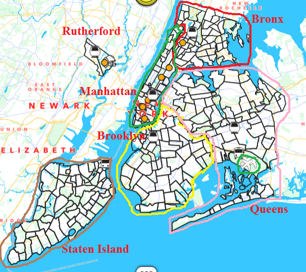
The vast and vibrant tapestry of New York City is composed of five distinct boroughs, each offering its own unique character, attractions, and experiences. Among these, Queens stands as a testament to the city’s incredible diversity and sprawling urban landscape, directly bordering the iconic island of Manhattan. Understanding the distance and the various methods of traversing between these two boroughs is fundamental for any traveler aiming to maximize their exploration of the Big Apple. The answer to “How far is Queens from Manhattan?” is not a simple, single number, but rather a consideration of geography, specific starting and ending points, and the chosen mode of transportation.
Geographical Proximity and Defining the Borders
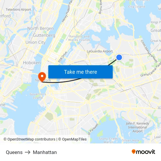
Queens and Manhattan share a significant border, primarily defined by the East River. This waterway acts as a natural delimiter, with the westernmost edge of Queens meeting the eastern shores of Manhattan. However, “distance” in this context can vary dramatically. For instance, a point in western Astoria, a neighborhood in Queens that hugs the East River, might be mere miles, or even less, from the easternmost tip of Manhattan, such as the Upper East Side or Midtown East.
Conversely, if one considers the distance from, say, the heart of Jamaica, a major commercial and transportation hub in central Queens, to the westernmost point of Manhattan in Battery Park City or Financial District, the mileage increases substantially. This nuanced understanding of “distance” is crucial when planning travel itineraries and estimating transit times. The sheer size of Queens, being the largest borough by land area in New York City, means that proximity to Manhattan is a relative concept, heavily dependent on the specific neighborhoods involved.
Navigating the East River: Bridges and Tunnels
The primary connectors between Queens and Manhattan are the numerous bridges and tunnels that span the East River. Each of these arteries offers a distinct experience and contributes to the varying travel times.
Iconic Bridges:
- Queensboro Bridge (also known as the 59th Street Bridge): This magnificent cantilever bridge connects Long Island City in Queens with Midtown Manhattan at 59th Street. It’s a popular choice for drivers and cyclists, offering impressive views of the Manhattan skyline. The distance from the Queens entrance to the Manhattan exit is approximately 1.2 miles, but driving time can range from 10 to 30 minutes depending on traffic.
- Triborough Bridge (now the Robert F. Kennedy Bridge): This complex of bridges and ramps connects Queens, Manhattan, and the Bronx. For travel between Queens and Manhattan, the span from Ward’s Island (connected to Queens) to the East Harlem side of Manhattan is the relevant section. The overall driving distance can be around 3.5 miles from LaGuardia Airport area to Manhattan, with travel times varying significantly due to congestion.
- Hell Gate Bridge: Primarily a rail bridge, this iconic structure is less relevant for direct vehicular or pedestrian travel between the boroughs but is a significant landmark and engineering feat.
Vital Tunnels:
- Queens-Midtown Tunnel: This tunnel provides a direct link from Long Island City in Queens to 53rd Street in Midtown Manhattan. The tunnel itself is approximately 3,330 feet long. Driving time is typically between 10 to 25 minutes, heavily influenced by traffic volume.
- Hugh L. Carey Tunnel (formerly the Battery Park Tunnel): This tunnel connects Red Hook, Brooklyn, and Queens to Lower Manhattan, near Battery Park. While it directly connects parts of Queens to downtown Manhattan, the journey can be longer than the Midtown Tunnel.
Transportation Options and Time Estimates
The choice of transportation significantly impacts the distance and time taken to travel from Queens to Manhattan. Each method offers a unique perspective on the urban landscape and its connectivity.
Public Transportation: The Subway Network
The Metropolitan Transportation Authority (MTA) subway system is the lifeblood of New York City and offers a highly efficient, albeit sometimes crowded, way to bridge the gap between Queens and Manhattan. Several subway lines directly connect the two boroughs, making the perceived distance almost negligible for many residents and tourists.
- The E and M trains: These lines run from central and western Queens (e.g., Jamaica-E 179th Street, Forest Hills-71st Avenue) directly into Midtown Manhattan, with stations at Court Square, Lexington Avenue/53rd Street, and 5th Avenue/53rd Street. A typical journey from Jamaica to Midtown Manhattan can take approximately 30-40 minutes.
- The 7 train: This distinctive local line runs from Flushing in eastern Queens through Long Island City and into Grand Central Terminal in Manhattan. The distance from Flushing-Main Street to Grand Central-42nd Street is roughly 9.6 miles, and the ride typically takes about 35-45 minutes.
- The F train: Connecting eastern and central Queens (e.g., Jamaica-179th Street) with Lower and Midtown Manhattan, the F train provides another vital link. Travel times from Jamaica to the Financial District might be around 45-55 minutes.
- The G train: This unique crosstown line connects parts of Queens (e.g., Court Square, Greenpoint Avenue) with Brooklyn, without directly entering Manhattan. However, it serves as a crucial transfer point for accessing Manhattan via other lines.

Driving and Ride-Sharing Services
For those preferring the convenience or speed of a private vehicle, driving or using ride-sharing services like Uber or Lyft offers another avenue. The distances are the same as those covered by bridges and tunnels, but travel times are highly susceptible to New York City’s notorious traffic.
- From western Queens (e.g., Long Island City) to Midtown Manhattan: This is the shortest driving distance, often under 5 miles. Without traffic, the journey could be as quick as 10-15 minutes via the Queensboro Bridge or Queens-Midtown Tunnel. During peak hours, however, expect travel times to stretch to 30-60 minutes or even longer.
- From central or eastern Queens (e.g., Jamaica, Flushing) to Manhattan: The distances increase, ranging from 10 to 15 miles or more to reach different parts of Manhattan. Driving times can easily exceed an hour, especially during rush hour, when navigating the Grand Central Parkway, Van Wyck Expressway, and Bruckner Expressway towards the bridges or tunnels.
Ferries: A Scenic Alternative
For a more picturesque approach, the New York City Ferry system offers a unique perspective. Several routes connect Queens to Manhattan, providing a comfortable and scenic commute, often with breathtaking views of the Manhattan skyline and iconic landmarks.
- Astoria Route: This route connects Astoria and Long Island City in Queens with destinations in Midtown East and Lower Manhattan, including stops at East 34th Street and Wall Street/Pier 11. The ferry ride itself is a pleasant experience, and travel times between stops are generally consistent, often around 20-40 minutes depending on the origin and destination.
Factors Influencing Perceived Distance
The “distance” between Queens and Manhattan is not solely a matter of miles but is heavily influenced by a confluence of factors that shape the overall travel experience.
Traffic Conditions
As highlighted, traffic is perhaps the most significant variable impacting travel time. New York City is world-renowned for its congested roadways, particularly during morning and evening commutes. What might be a 15-minute drive during off-peak hours can easily become a 45-minute to an hour-long ordeal during rush hour. This unpredictability makes it essential for travelers to factor in buffer time, especially when relying on vehicles for transit. The subway and ferry services, while subject to their own delays, generally offer more predictable travel durations, as they are less affected by road traffic.
Specific Neighborhoods
The actual mileage and travel time depend critically on the starting and ending points within Queens and Manhattan. Traveling from the westernmost edge of Queens, such as Astoria or Long Island City, to Midtown Manhattan is a considerably shorter undertaking than traveling from the eastern parts of Queens, like Jamaica or Flushing, to Lower Manhattan. This variation underscores the importance of consulting maps and transit apps to ascertain the most efficient routes based on your specific destinations.
Time of Day and Week
Beyond the typical rush hours, other factors like special events, weather conditions, and even weekends can influence travel times. Major events in Manhattan can lead to increased traffic and public transit demand, affecting journeys originating from Queens. Similarly, construction projects on bridges and tunnels can cause significant disruptions.
Tourist vs. Local Perspective
For a tourist, the “distance” might also be perceived through the lens of the experience. A subway ride, while efficient, offers a subterranean view of the city. A drive over a bridge provides panoramic vistas, and a ferry trip presents a unique, water-level perspective. Each mode of transport redefines the journey and the sense of distance between these two vibrant boroughs. The ease of access and the seamless integration of Queens into the broader New York City experience are defining characteristics that make it an essential component of any visit to the metropolis.
LifeOutOfTheBox is a participant in the Amazon Services LLC Associates Program, an affiliate advertising program designed to provide a means for sites to earn advertising fees by advertising and linking to Amazon.com. Amazon, the Amazon logo, AmazonSupply, and the AmazonSupply logo are trademarks of Amazon.com, Inc. or its affiliates. As an Amazon Associate we earn affiliate commissions from qualifying purchases.