California, a land of unparalleled natural beauty and vibrant urban centers, beckons millions of travelers each year with its diverse landscapes, from sun-drenched beaches and towering redwood forests to snow-capped mountains and expansive deserts. This Golden State offers an incredible array of destinations and attractions, catering to every kind of adventurer, from those seeking luxury travel experiences at world-class resorts to budget-conscious backpackers exploring its many national parks. Yet, beneath the surface of this dazzling allure lies a complex and often precarious reality: how does this famously dry state, home to nearly 40 million people and a colossal agricultural industry, sustain itself with water? The answer is a fascinating tapestry woven from natural phenomena, ingenious engineering, and ongoing human effort, profoundly impacting its tourism, lifestyle, and very identity.

Understanding where California gets its water is crucial not just for its residents, but for anyone who wishes to truly grasp the dynamics of this unique place. Water shapes everything here, from the verdant vineyards that define its food tourism to the existence of its sprawling cities, and even the availability of pristine [lakes] and rivers for [outdoor activities]. It’s a story of balancing an ever-growing demand with a naturally limited and increasingly variable supply, a challenge that influences everything from urban planning and agricultural practices to the very nature of accommodation and hotel development in prime [tourist] areas.
The Lifelines of the Golden State: Primary Water Sources
[California]’s water supply is a mosaic, pieced together from various natural sources, each contributing to the state’s complex hydrological system. These sources are the fundamental building blocks upon which the state’s infrastructure and way of life are built.From Mountain Snow to Atmospheric Rivers: Precipitation’s Bounty
The most intuitive source of water for any region is precipitation, and for [California], this primarily comes in two forms: snowmelt from its majestic mountain ranges and rainfall, sometimes dramatically delivered by powerful atmospheric rivers.
The Sierra Nevada Mountains are unequivocally [California]’s primary natural reservoir. Each winter, these towering peaks receive prodigious amounts of snowfall, accumulating into a critical “snowpack.” This snowpack acts as a natural storage system, slowly melting in the spring and summer months to feed rivers and streams that flow westward across the state. The volume of this snowpack is meticulously measured, as it directly dictates the water supply for the coming year. When visitors flock to the [Sierra Nevada Mountains] for [skiing] in winter or hiking in summer, they are engaging with the very heart of [California]’s water cycle. Iconic [landmarks] like Lake Tahoe, renowned for its crystal-clear waters and stunning alpine scenery, and Yosemite National Park, with its powerful waterfalls and pristine rivers, are direct beneficiaries and indicators of this crucial snowmelt. The beauty of these [destinations] is inextricably linked to the health of the snowpack.
Beyond the traditional winter snows, Atmospheric Rivers have emerged as another significant, albeit volatile, source of precipitation. These are long, narrow bands of moisture-laden air that transport water vapor from the tropics across the Pacific Ocean, often making landfall in [California]. When they do, they can unleash torrents of rain, often referred to as “pineapple express” events, which can be both a blessing and a curse. While they can quickly alleviate drought conditions and replenish reservoirs, their intensity can also lead to destructive floods, landslides, and significant disruptions to [travel] and daily [lifestyle], particularly in areas like the San Francisco Bay Area and along the state’s coastline. Managing the benefits and risks of these powerful weather phenomena is a constant challenge for water managers.
Beneath the Surface: Groundwater Reserves
While rivers and snowmelt are visible and dramatic, a vast and often unseen source of water lies beneath the state’s surface: groundwater. Stored in underground aquifers, groundwater is pumped to the surface to meet various needs, particularly in agricultural regions and during periods of drought when surface water supplies dwindle. It acts as a critical buffer, providing resilience in times of scarcity.
The Central Valley, one of the world’s most productive agricultural regions, is heavily reliant on groundwater. Here, the irrigation of vast almond orchards, vineyards, and vegetable fields depends significantly on water drawn from deep underground. This reliance underscores the importance of groundwater for [California]’s economy, its role in national food supply, and its influence on local [culture] and [food tourism]. However, this extensive pumping has led to serious issues, most notably subsidence, where the land literally sinks due to the compaction of aquifers. This not only damages infrastructure but also reduces the future storage capacity of these vital underground reservoirs, highlighting a significant sustainability challenge.
The Mighty Rivers and Vast Lakes: Interstate and Intrastate Waterways
[California]’s water network is further enriched by several major rivers and their associated lakes, some originating within the state and others crossing state lines, necessitating complex agreements and management strategies.The Colorado River is perhaps the most famous and contentious interstate water source. Originating in the [Rocky Mountains] and flowing through seven U.S. states (Colorado, Wyoming, Utah, New Mexico, Arizona, Nevada, and [California]) and into [Mexico], the [Colorado River] is a lifeline for millions. [California]’s share of its waters is allocated through the Colorado River Compact, a foundational agreement from 1922, and subsequent treaties. Much of this water is diverted to [Southern California], serving the metropolitan areas of Los Angeles and [San Diego], and irrigating agricultural lands in the [Imperial Valley]. The vast reservoirs of Lake Mead and Lake Powell, though located primarily outside [California], are critical components of this system, regulating water flow and storing vast quantities of water. For those on a [road trip] across the American Southwest, visiting these monumental [lakes] offers a stark reminder of the scale of water management in the region, providing scenic [attractions] and [outdoor activities] like boating and fishing.
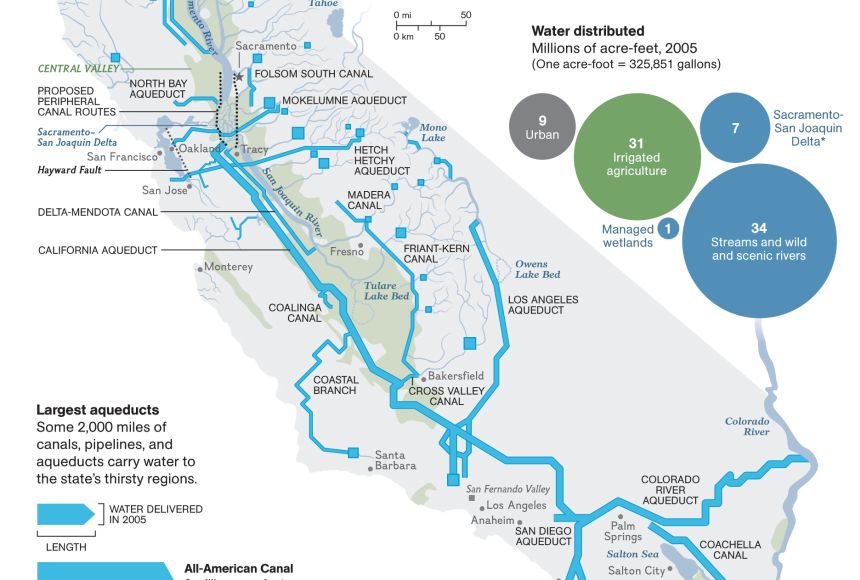
Within [California], the Sacramento-San Joaquin Delta stands as the crucial hub of the state’s freshwater system. This vast network of channels, islands, and levees, where the [Sacramento River] and [San Joaquin River] converge before flowing into the [San Francisco Bay], is the point from which much of [California]’s water is pumped south. Ecologically vital, it supports a diverse array of fish and wildlife, making it a significant area for [nature tourism]. However, the Delta is also incredibly fragile, facing challenges from rising sea levels, aging infrastructure, and the ecological impacts of water diversions.
Other significant intrastate rivers, originating primarily in the [Sierra Nevada Mountains], include the Feather River, American River, and Tuolumne River. These rivers feed major reservoirs and provide water to cities like Sacramento, and contribute to the network that sustains the state. Their surrounding areas also offer fantastic [travel] opportunities for [camping], [whitewater rafting], and enjoying the natural beauty of [Northern California].
Engineering Marvels: California’s Water Infrastructure
To move water from where it naturally occurs (primarily [Northern California] and the [Sierra Nevada Mountains]) to where it is needed (the arid south and the [Central Valley]’s farmlands), [California] has constructed an astounding network of dams, aqueducts, canals, and pumping stations. These engineering feats are [landmarks] in their own right, vital to the state’s modern existence and a testament to human ingenuity.
The State Water Project (SWP) and Central Valley Project (CVP)
The two largest and most complex water conveyance systems are the State Water Project (SWP) and the Central Valley Project (CVP). Together, they form the backbone of [California]’s water distribution.
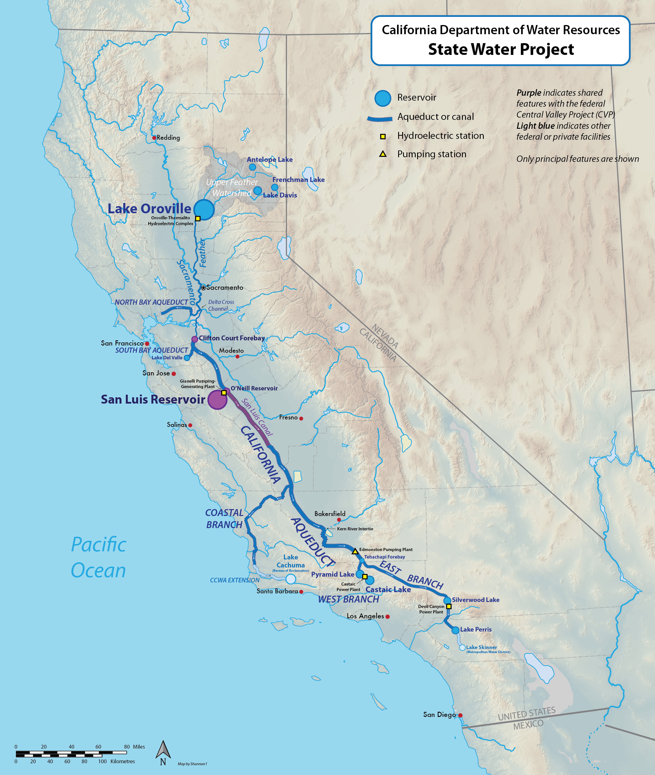
The State Water Project (SWP) is a gargantuan undertaking managed by the State of [California]. It spans over 700 miles, delivering water to 27 million people and nearly a million acres of farmland. Its main components include the Oroville Dam, the tallest earth-filled dam in the U.S., and the California Aqueduct, a massive open canal that stretches hundreds of miles, crossing mountains and valleys to carry water from [Northern California] to the [Central Valley] and [Southern California]. The sheer scale of the [California Aqueduct] is a striking sight, a man-made river snaking through the landscape, enabling life and prosperity in regions that would otherwise be barren. Visiting structures like the [Oroville Dam], while primarily functional, offers a sense of the immense scale of infrastructure required to sustain the state’s [lifestyle].
The Central Valley Project (CVP) is a federal water management project operated by the U.S. Bureau of Reclamation. It focuses primarily on supplying water for agricultural irrigation in the [Central Valley] but also provides municipal and industrial water, generates hydropower, and offers flood control. Key facilities of the CVP include the impressive Shasta Dam, the second-largest dam in [California], and the Friant Dam on the [San Joaquin River]. These projects, while not typically [tourist attractions] in the traditional sense, represent monumental achievements in engineering and resource management that have fundamentally shaped [California]’s development and its capacity to feed the nation.
Historic Aqueducts: Fueling Urban Growth
Before the development of the larger statewide projects, major metropolitan areas built their own ambitious aqueducts to secure independent water supplies, forever altering their growth trajectory.
The Los Angeles Aqueduct is an icon of [California]’s water history, a testament to the ambitious vision (and controversies) of early 20th-century urban development. Completed in 1913 under the leadership of engineer William Mulholland, this 233-mile system diverted water from the [Owens Valley] in the [Eastern Sierra Nevada] to power the exponential growth of [Los Angeles]. Its construction was a marvel of engineering for its time, but also sparked intense conflict, famously known as the “California Water Wars.” Today, parts of the [Los Angeles Aqueduct] system remain crucial for [Los Angeles]’s water supply, a powerful reminder of how water has dictated the very existence and expansion of one of the world’s largest cities. Historical tours and interpretive centers along its route provide insights into this pivotal chapter of [California]’s past, blending history with [urban tourism].
Similarly, the Hetch Hetchy Aqueduct provides pristine drinking water to the [San Francisco Bay Area], primarily to the city of [San Francisco]. Its source is the [Hetch Hetchy Reservoir], located within [Yosemite National Park] on the [Tuolumne River]. The damming of the [Hetch Hetchy Valley] in the early 20th century, though providing a reliable water source, was a highly contentious decision, sparking an early and significant battle between conservationists and urban developers. While the controversy lingers, the system continues to deliver high-quality water, underscoring the delicate balance between natural preservation and the needs of a growing population and its modern [lifestyle].
Navigating Scarcity: Sustainability and the Future of California’s Water
Despite the elaborate infrastructure and diverse sources, [California]’s water supply is chronically challenged by its arid climate, fluctuating precipitation patterns, and the relentless demands of a large population and agricultural sector. The state is at the forefront of developing innovative solutions to ensure a sustainable water future.
Battling Droughts and Promoting Conservation
Droughts are a recurring and defining feature of [California]’s climate, sometimes lasting for years. These periods of extreme dryness significantly stress the state’s water systems, leading to depleted reservoirs, increased reliance on groundwater, and severe impacts on [agriculture], natural ecosystems, and even [tourism]. Lake levels can drop dramatically, affecting recreational [activities] like boating and fishing, and altering the landscapes that attract visitors.
In response, conservation efforts have become a cornerstone of [California]’s water strategy. These range from public awareness campaigns encouraging shorter showers and drought-tolerant landscaping (xeriscaping) to mandatory water-efficiency standards for appliances and plumbing fixtures. Many [hotels] and [resorts] across the state have implemented water-saving initiatives, reflecting a broader shift in [local culture] towards responsible resource management. These efforts are not just about reducing consumption; they are about fostering a water-wise [lifestyle] that recognizes the value of every drop.
Innovative Solutions: Recycling, Desalination, and Stormwater Capture
Beyond conservation, [California] is investing heavily in advanced technologies and innovative approaches to expand its water portfolio.
Water recycling and reuse are gaining significant traction. Pioneering efforts, such as those by the Orange County Water District, involve advanced purification processes that treat wastewater to a potable standard, allowing it to be recharged into groundwater basins. This essentially creates a “local drought-proof” water supply, reducing reliance on imported water and enhancing regional water security. Such projects are critical for urban areas, transforming what was once waste into a valuable resource, and showcasing a cutting-edge approach to environmental sustainability.
Desalination, the process of removing salt from seawater, is another technological solution, particularly for coastal communities. The Claude “Bud” Lewis Carlsbad Desalination Plant, near [San Diego], is the largest such plant in the Western Hemisphere, providing a significant amount of drinking water to the region. While desalination is energy-intensive and costly, it offers a reliable, climate-independent source of water, crucial for securing the future of [Southern California]’s population and its thriving [tourism] industry.
Finally, stormwater capture projects are becoming increasingly important in urban settings. Instead of allowing rainwater to run off into the ocean, cities are implementing systems to collect, treat, and infiltrate stormwater into groundwater aquifers or use it for irrigation. This not only augments local water supplies but also helps manage urban flooding and improves water quality in receiving bodies.
Water’s Enduring Influence on California’s Charm and Character
The story of water in [California] is not merely one of infrastructure and resource management; it’s a narrative that profoundly shapes the state’s character, its appeal to [travelers], and the daily [lifestyle] of its residents. The availability (or scarcity) of water dictates where and how people live, what industries thrive, and what natural wonders endure.
From the lush, redwood-filled landscapes of [Northern California] to the vibrant agricultural fields of the [Central Valley] and the bustling metropolises of [Southern California], water has been the fundamental determinant of regional identities. The presence of water allows for the cultivation of world-renowned vineyards, making regions like [Napa Valley] and [Sonoma County] global [food tourism] hotspots. It feeds the rivers that beckon adventurers for [rafting] and [fishing], and fills the [lakes] that offer serene retreats for [boating] and [camping].
For the discerning [traveler], understanding [California]’s water story adds a deeper layer to their experience. A visit to the snow-capped peaks of the [Sierra Nevada] reveals the source of the state’s lifeblood. Exploring the urban oases of [Los Angeles] or [San Francisco] becomes a contemplation of the colossal efforts required to sustain such vibrant [lifestyles] in an arid environment. Even booking [accommodation] at a coastal [resort] can spark thought about the journey of the water that fills its pools or provides its refreshing showers.
Ultimately, [California]’s relationship with water is a continuous balancing act — between human needs and environmental protection, historical allocations and future demands, natural variability and technological solutions. It’s a challenge that defines the state and one that will continue to shape its spectacular [destinations], its innovative [lifestyle], and its enduring appeal to the world. As [California] looks to the future, its ability to sustainably manage this most precious resource will determine its continued prosperity and its capacity to remain a golden beacon for [travel], [tourism], and a unique way of life.
LifeOutOfTheBox is a participant in the Amazon Services LLC Associates Program, an affiliate advertising program designed to provide a means for sites to earn advertising fees by advertising and linking to Amazon.com. Amazon, the Amazon logo, AmazonSupply, and the AmazonSupply logo are trademarks of Amazon.com, Inc. or its affiliates. As an Amazon Associate we earn affiliate commissions from qualifying purchases.