The Sunshine State, a beloved destination for millions of tourists, vacationers, and new residents, also finds itself at the epicenter of a much more formidable force of nature: hurricanes. Year after year, the southeastern tip of the United States braces for the potential onslaught of these powerful tropical cyclones. But why is Florida so uniquely susceptible to these dramatic weather events? The answer lies in a potent combination of geography, oceanography, and atmospheric conditions that create a perfect storm for hurricane formation and intensification.
This article delves into the meteorological and geographical factors that make the Sunshine State a recurring target for hurricanes, exploring the genesis of these storms, their typical pathways, and how these phenomena interact with Florida’s unique environment. We’ll also touch upon how this recurring reality shapes the travel, tourism, and lifestyle experiences within the state.
The Perfect Brewing Ground: Where Hurricanes Begin
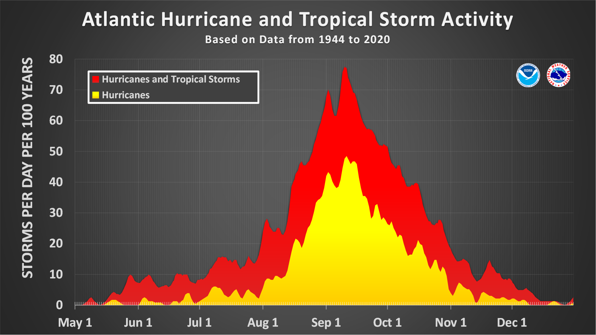
Hurricanes are not born overnight. They are complex atmospheric phenomena that require a specific set of ingredients to form and strengthen. For Florida, a confluence of these ingredients is frequently present, particularly during the Atlantic hurricane season, which officially runs from June 1 to November 30.
Warm Ocean Waters: The Fuel for the Fire
The most crucial ingredient for hurricane development is warm ocean water. Tropical cyclones draw their energy from the heat and moisture evaporating from the sea surface. Specifically, sea surface temperatures need to be at least 26.5 degrees Celsius (80 degrees Fahrenheit) down to a depth of about 50 meters. The warm waters of the western Atlantic Ocean and the Caribbean Sea, bordering Florida’s extensive coastlines, consistently meet this requirement during the summer and fall months.
The Gulf of Mexico, with its shallower waters that heat up quickly, also plays a significant role. Its warm embrace provides a fertile breeding ground for tropical disturbances that can rapidly escalate into hurricanes before making landfall in Florida. The sheer volume of warm water available in these regions acts like a vast, perpetually replenished fuel tank for developing storms.
Atmospheric Instability and Moisture
Beyond warm waters, a tropical disturbance needs an unstable atmosphere. This means that the air near the surface is significantly warmer and moister than the air higher up. This difference in temperature and density allows warm, moist air to rise rapidly, forming towering cumulonimbus clouds – the building blocks of thunderstorms. As these thunderstorms organize and cluster together, fueled by the abundant moisture from the ocean, they begin to rotate.
The tropical Atlantic and the Caribbean are notorious for their conducive atmospheric conditions. High humidity levels and a lack of strong wind shear – changes in wind speed and direction with altitude – allow these thunderstorms to coalesce and strengthen without being torn apart. Low wind shear is particularly vital; if winds at different altitudes are blowing in vastly different directions or at significantly different speeds, the developing storm’s structure is disrupted, hindering its intensification.
The Role of Tropical Waves
Many hurricanes originate from tropical waves, which are elongated areas of low pressure that move westward across the tropics. These waves can be thought of as ripples in the atmosphere that originate off the coast of Africa and traverse the Atlantic. As they move over warm ocean waters and encounter favorable atmospheric conditions, these waves can spawn clusters of thunderstorms. If these thunderstorms continue to organize and intensify, they can evolve from a tropical depression to a tropical storm, and eventually to a hurricane.
Florida’s position on the western edge of the Atlantic basin makes it a prime recipient of these African dust plumes and the associated tropical waves that often carry the seeds of hurricanes. The trajectory of these waves frequently directs them towards the southeastern United States, with Florida being the first landmass they are likely to encounter.
Navigating the Tracks: Why Florida is in the Storm’s Path
Beyond the ingredients for formation, Florida’s geographical position dictates its susceptibility to hurricane tracks. Several prevailing weather patterns and oceanic currents funnel these storms towards the state.
The Bermuda High: A Steering Influence
A dominant feature influencing hurricane tracks in the Atlantic is the Bermuda High, a semi-permanent high-pressure system that typically resides over the North Atlantic Ocean. This massive anticyclone acts like a large obstacle in the atmosphere, influencing the movement of weather systems, including hurricanes.
During the peak of hurricane season, the Bermuda High often steers developing storms westward and then northwestward. For storms that form in the eastern or central Atlantic, this steering flow can direct them directly towards the southeastern United States. If a storm forms south of the Bermuda High, it might track more directly westward towards the Caribbean and the Gulf of Mexico, eventually threatening Florida’s western or southern coasts.
The Influence of the Jet Stream
The position and strength of the jet stream, a fast-flowing river of air high in the atmosphere, also play a crucial role. In late summer and early fall, the jet stream tends to shift northward. This shift can create a pattern where storms moving westward are “caught” in the flow and steered towards the Atlantic coast of the United States.
When a hurricane approaches Florida, the interaction between the Bermuda High and the jet stream can dictate whether the storm continues its westward track, curves northward along the coast, or even moves offshore. For Florida, a westward track from the Atlantic is particularly concerning, as it increases the likelihood of direct landfall.
The Gulf of Mexico Factor
The Gulf of Mexico presents its own set of risks. Storms that form in the Caribbean Sea or move into the Gulf can be influenced by local atmospheric conditions within the gulf. These storms often track westward or northwestward, posing a significant threat to Florida’s gulf coast, from the Florida Panhandle down to the Everglades. The warm waters of the Gulf can also contribute to rapid intensification of storms before they reach land.
The presence of bays, inlets, and extensive coastlines in Florida also means that even storms that don’t make direct, major landfalls can bring significant storm surge and rainfall to vast areas. The state’s low-lying topography exacerbates the impact of storm surge, a rise in sea level caused by the hurricane’s winds pushing water towards the shore.
Florida’s Unique Coastal Geography and Its Impact
Florida’s distinctive shape and extensive coastline are critical factors in its vulnerability to hurricanes. The state boasts over 1,350 miles of tidal shoreline, more than any other state in the contiguous United States. This vast exposure means that a large portion of the state’s population and infrastructure is situated within relatively close proximity to the coast.
Peninsula Geography
Florida is a peninsula, meaning it is surrounded by water on three sides. This geographical characteristic makes it susceptible to hurricanes approaching from both the Atlantic Ocean to the east and the Gulf of Mexico to the west. A storm that might miss the east coast could easily track around the southern tip of the peninsula and threaten the west coast, or vice versa. This “double-edged sword” of exposure significantly increases the odds of a hurricane impacting Florida at some point during the season.
Low-Lying Terrain
Much of Florida’s landmass is characterized by low-lying elevation. This is particularly true for the southern and coastal regions. When a hurricane makes landfall, it brings with it a dangerous storm surge. In low-lying areas, this surge can inundate vast inland areas, causing widespread flooding that can be more damaging than high winds alone. Cities like Miami, Fort Lauderdale, and the coastal communities of Southwest Florida are particularly vulnerable to this phenomenon.
The Role of Islands and Keys
The Florida Keys, a chain of tropical islands stretching southwestward from the mainland, are exceptionally exposed. Their low elevation and isolated nature make them highly susceptible to direct impacts from storm surge and winds. Even minor hurricanes can cause significant damage to these delicate ecosystems and their communities.

Hurricanes and Florida: A Persistent Reality
The combination of warm waters, favorable atmospheric conditions, and Florida’s geographical position creates a perfect storm for frequent hurricane activity. While the state’s natural beauty and vibrant tourism industry attract visitors, the recurring threat of hurricanes is an undeniable aspect of life and travel in Florida.
Understanding why Florida experiences so many hurricanes is crucial for residents, businesses, and travelers alike. It informs preparation strategies, drives infrastructure development (such as robust building codes and evacuation plans), and shapes the very rhythm of life in the Sunshine State. For those planning a visit, awareness of the hurricane season and potential impacts is an essential part of responsible travel planning. Whether you’re booking a stay at a luxury resort in Miami, exploring the natural wonders of the Everglades, or seeking a budget-friendly escape in the Florida Panhandle, understanding this meteorological reality is key to a safe and enjoyable experience. The allure of Florida’s beaches, theme parks like Walt Disney World, and vibrant cities remains strong, but always with the understanding that nature’s power is a significant and ever-present factor.