California, a state synonymous with sunshine, sprawling beaches, and a seemingly endless summer, is undeniably hot. But it’s not just the pleasant warmth that draws millions; it’s a dynamic interplay of geography, climate patterns, and unique meteorological phenomena that create its signature sweltering conditions. For travelers seeking to understand the Golden State’s allure, or those planning their perfect getaway, grasping the reasons behind its heat is key to unlocking a more informed and enjoyable experience. Whether you’re dreaming of a luxurious stay in a beachfront resort, exploring iconic landmarks, or immersing yourself in the vibrant local culture, understanding the heat helps tailor your itinerary, from the best times to visit the iconic Disneyland to the ideal season for wine tasting in the Napa Valley.
The Geographic Canvas: Setting the Stage for Heat
California’s vast and varied landscape plays a foundational role in its temperature extremes. The sheer scale of the state, stretching over 800 miles from north to south, means it encompasses a wide range of climates. However, several key geographical features converge to create pockets of intense heat, particularly in its southern and inland regions.
Mountains and Valleys: The Heat Traps
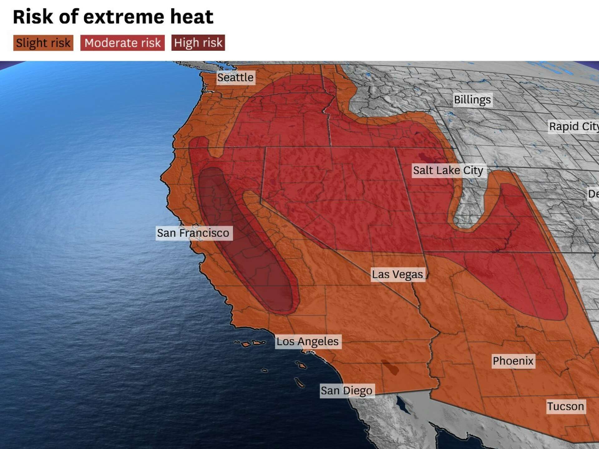
The Sierra Nevada mountain range to the east acts as a significant barrier, influencing weather patterns for the entire state. To its west, in Central California, lies the Great Central Valley. This expansive agricultural heartland is a prime example of a heat trap. Surrounded by mountains on three sides, the valley experiences a continental climate, with hot, dry summers. Air masses that move into the valley can become stagnant, allowing solar radiation to heat the ground intensely. This trapped heat then warms the air above, leading to scorching temperatures that can soar well above 100°F (38°C). Cities like Bakersfield and Fresno are notorious for their summer heat, making early morning or late evening explorations of their local attractions and dining scene advisable, especially if you’re looking for budget-friendly travel options.
Similarly, the southern California desert regions, including the Mojave Desert and the Colorado Desert, are subjected to extreme heat due to their low elevation, arid conditions, and lack of moderating ocean influence. These areas, home to landmarks like Joshua Tree National Park and Death Valley National Park, are some of the hottest places on Earth. The intense solar radiation bakes the desert floor, and the dry air retains heat efficiently, leading to temperatures that can be dangerous for unprepared visitors. Proper hydration and seeking shade are paramount when exploring these natural wonders, regardless of whether you’re on a luxury travel adventure or a more grounded budget trip.
The Coastal Advantage (and its Limits)
California’s iconic coastline offers a stark contrast to its inland valleys and deserts. The Pacific Ocean acts as a natural air conditioner, moderating temperatures for coastal cities like Los Angeles and San Diego. The cool ocean currents, particularly off the coast of Southern California, bring refreshing sea breezes that can keep summer temperatures pleasantly mild, often in the 70s and 80s Fahrenheit (20s Celsius). This is why many of the state’s most popular tourist destinations, including world-renowned resorts and family-friendly attractions, are clustered along the coast.
However, even the coast isn’t immune to heat. When prevailing winds shift, or during specific atmospheric conditions, the moderating effect of the ocean can be diminished. Furthermore, urban heat island effects in densely populated coastal cities can contribute to higher temperatures, especially at night, impacting the experience for those staying in urban hotels or apartments. The allure of a coastal stay, with its access to beautiful beaches and vibrant city life, is undeniable, but understanding the potential for heat waves, even by the sea, is part of smart travel planning.
The Atmospheric Architects: Shaping California’s Climate
Beyond the static geography, dynamic atmospheric forces are constantly at play, dictating the flow of heat across California. Understanding these patterns is crucial for anticipating temperature fluctuations and planning activities, from visiting historical landmarks to enjoying local food festivals.
The Pacific High and the Santa Ana Winds: A Volatile Duo
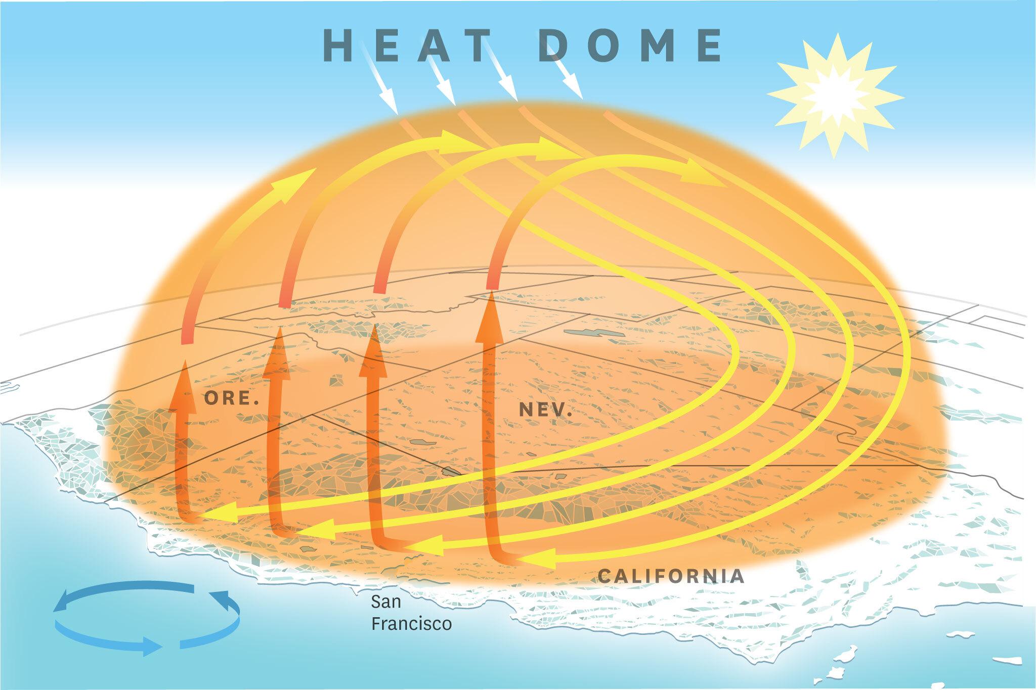
Two key players in California’s climate are the Pacific High pressure system and the notorious Santa Ana winds. The Pacific High, a semi-permanent feature during the summer months, is responsible for clear skies and dry conditions along much of the West Coast. Its presence allows for intense solar heating, particularly inland.
The Santa Ana winds are a different beast altogether, typically making their appearance in the fall and winter, but their influence can sometimes extend into other seasons, exacerbating dry and hot conditions. These are hot, dry downslope winds that originate in the desert interior and flow towards the coast. As the air descends from the higher elevations of the desert, it is compressed and warms significantly. These winds can dramatically increase temperatures, lower humidity, and contribute to wildfire risks. For travelers visiting during these periods, especially those venturing into areas like Orange County or the Los Angeles basin, extreme heat and dry conditions are to be expected. Being prepared with protective clothing and ample water is essential for any outdoor activities or visits to popular attractions.
Marine Layer and Fog: The Coastal Coolers
In stark contrast to the Santa Anas, the marine layer is a significant factor in keeping coastal California relatively cool during the summer. This phenomenon occurs when moist, cool air from the Pacific Ocean moves inland, often topped by a layer of warmer, drier air. This inversion traps moisture near the surface, leading to the characteristic coastal fog and low clouds that often blanket areas like San Francisco and parts of Los Angeles in the morning. While this can dampen the sun initially, it usually burns off by late morning or early afternoon, revealing the milder temperatures that coastal dwellers and visitors enjoy. This natural air conditioning is a major draw for those seeking respite from the inland heat, making coastal accommodations like hotels and resorts particularly desirable during peak summer.
Factors Influencing Local Heat: Nuances in Experience
While broad climatic patterns explain California’s heat, specific local conditions and human activities also play a role, influencing the experience of travelers and residents alike. Understanding these nuances can help refine travel plans, from booking accommodation to choosing the best time for outdoor experiences.
Urban Heat Islands: Concentrated Warmth
In densely populated urban areas, the phenomenon of the urban heat island effect can contribute to significantly higher temperatures compared to surrounding rural areas. The prevalence of concrete, asphalt, and buildings absorbs and re-emits solar radiation more effectively than natural landscapes. Reduced vegetation further exacerbates this, as trees and green spaces provide shade and cooling through evapotranspiration. Cities like Los Angeles, Sacramento, and San Jose experience this effect, leading to warmer nights and hotter days, especially in the downtown cores. This means that a stay in a city center hotel might be noticeably warmer than a property on the outskirts or closer to the coast. For those interested in the lifestyle of these cities, planning activities during cooler parts of the day or seeking out parks and shaded areas is advisable.
Drought and Aridity: The Amplifying Effect
California is no stranger to periods of drought, and prolonged dry spells can intensify heat. When the land is dry, it absorbs more solar energy instead of using it for evaporation. This lack of moisture means that the ground heats up more rapidly and to higher temperatures, which in turn heats the air above. This effect is particularly pronounced in the inland regions and desert areas, making summer heatwaves even more severe during drought conditions. For travelers planning trips to areas like Palm Springs or the Central Valley, being aware of potential drought conditions can inform packing choices and activity planning, emphasizing the need for sun protection and hydration.

Human Activity and Land Use
Human activities, such as agriculture and industrial processes, can also contribute to localized heat. For instance, irrigation in the Great Central Valley, while essential for food production, can influence local humidity levels. In industrial areas, the release of heat from factories and power plants can create localized warm spots. While these are typically minor contributors on a state-wide scale, they can add to the overall thermal load in specific locations, impacting the experience of those visiting or residing in these areas.
In conclusion, California’s heat is a multifaceted phenomenon driven by a complex interplay of geography, atmospheric forces, and local conditions. From the heat-trapping valleys and deserts to the moderating influence of the Pacific Ocean, and the dynamic shifts of wind patterns, each element contributes to the state’s diverse and often intense temperatures. Understanding these factors empowers travelers to better plan their California adventures, ensuring they can fully enjoy the state’s unparalleled attractions, whether they’re seeking luxury resorts, budget-friendly stays, immersive cultural experiences, or breathtaking natural landmarks. By being informed, visitors can truly make the most of the Golden State’s sunshine, embracing its warmth while navigating its extremes.