
Understanding the current and potential wildfire situation in California is crucial for travelers planning a visit, especially during the dry season. While fire maps are dynamic and can change rapidly, having access to reliable, up-to-date information can significantly impact travel plans, ensuring safety and enabling informed decisions about destinations and activities. This guide focuses on how to find and interpret fire maps to aid your exploration of the Golden State.
Navigating Wildfire Information for Travelers
Wildfires are a natural, albeit sometimes destructive, part of the California landscape. For travelers, awareness is key. Understanding where fires are currently burning, their proximity to popular tourist routes and attractions, and the potential for future outbreaks allows for a more secure and enjoyable travel experience. This section delves into the primary sources of wildfire information and how to use them effectively.
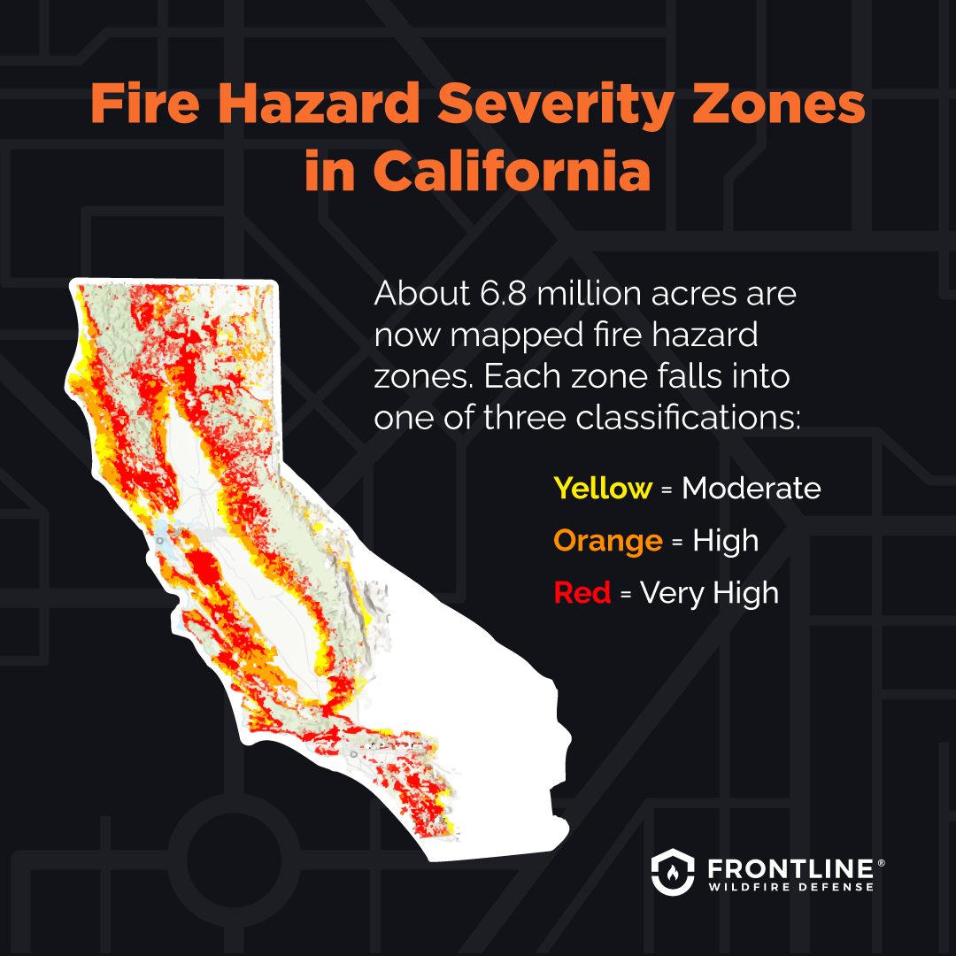
Official Sources for Fire Mapping
The most reliable information for wildfire status in California comes directly from official government agencies. These sources provide real-time data, incident reports, and predictive modeling.
CalFire’s Incident Information System
CalFire, the state’s primary firefighting agency, offers a comprehensive incident information system. This platform is an indispensable resource for travelers.
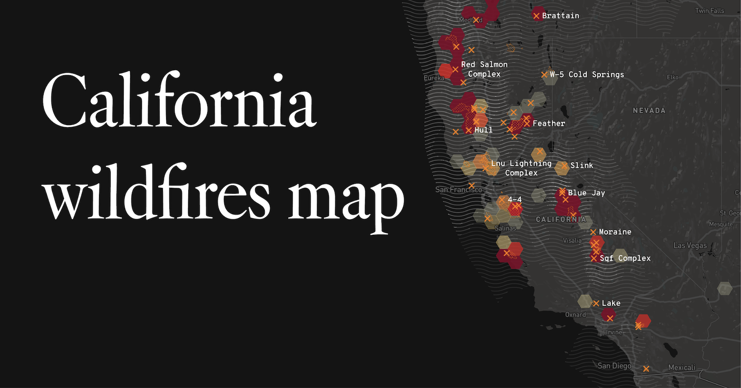
- Interactive Maps: The CalFire website features interactive maps that display active wildfires, containment lines, and predicted fire progression. These maps are typically updated multiple times a day, reflecting the most current status of incidents across the state.
- Incident Details: Beyond just location, these maps often link to detailed incident reports. These reports provide crucial information such as the name of the fire, its acreage, containment percentage, structures threatened, evacuation orders and warnings, and the estimated date of full containment.
- Road Closures and Evacuations: Critically for travelers, CalFire maps will often indicate road closures and evacuation zones. This information is vital for rerouting and ensuring you do not inadvertently drive into a dangerous area.
U.S. Forest Service and Bureau of Land Management
For fires occurring on federal lands, such as within national forests or managed by the Bureau of Land Management, these agencies also maintain their own incident reporting and mapping systems.
- National Interagency Fire Center (NIFC): The NIFC website acts as a central hub for national wildfire information, including significant fires in California. Their maps often highlight large and complex incidents.
- National Forest Websites: Individual National Forests (e.g., Los Padres National Forest, Sierra National Forest) will have specific alerts and closure information relevant to their areas, often including detailed maps of affected trails and roads.
Emergency Alerts and News Outlets
While not direct mapping tools, official emergency alert systems and reputable news outlets play a significant role in disseminating information about fires.
- County Emergency Services: Many California counties have their own emergency alert systems, often accessible via websites or mobile apps. These provide localized information on evacuations and advisories.
- Local News: Local television and radio stations, as well as their online counterparts, are often the fastest to report on developing fire situations and their impact on local communities and travel routes.
Interpreting Fire Maps for Travel Planning
Having access to a fire map is only the first step; understanding how to interpret the information is paramount for making sound travel decisions.
Key Elements to Look For on Fire Maps
When you access a wildfire map, several pieces of information are critical to understand your travel risk.
Active Fire Perimeters and Hotspots
- Red/Orange Areas: Typically, active fire perimeters are indicated by red or orange shading. The intensity of the color might sometimes denote the severity of the fire activity.
- Heat Signatures: Some advanced maps may display “hotspots” using infrared data, indicating areas of intense heat that may not be fully visible on standard maps. These can suggest areas of active burning.
Containment Lines
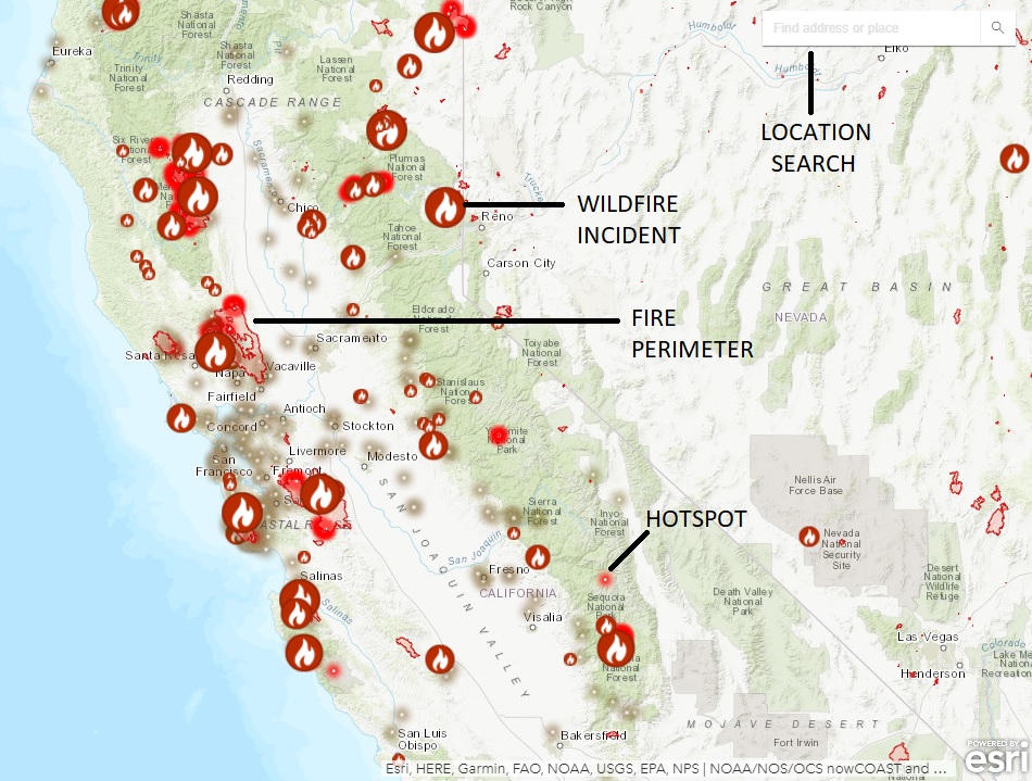
- Black or Green Lines: Containment lines, often shown in black or green, represent areas where firefighters have established control and are working to prevent the fire from spreading further. The percentage of containment is a key metric provided with incident reports.
Evacuation Orders and Warnings
- Distinct Shading or Icons: Evacuation zones are usually clearly marked.
- Evacuation Order (Red Zone): This signifies immediate danger, and residents and visitors must leave the area. Roads leading into and out of these zones may be closed.
- Evacuation Warning (Yellow Zone): This indicates a potential threat, and residents and visitors should prepare to evacuate if conditions worsen.
Road Closures and Infrastructure
- Red or Closed Road Icons: Fire maps are invaluable for identifying road closures. This is essential for planning your route to your chosen destination or attraction, such as the Golden Gate Bridge or a national park.
- Threatened Infrastructure: Some maps may highlight structures or vital infrastructure that are threatened by the fire, which can give an indication of the fire’s potential impact on surrounding areas.
Planning Your Trip Around Wildfire Conditions
California is a vast state with diverse landscapes, from the beaches of Southern California to the mountains of the Sierra Nevada. Understanding wildfire patterns can help you choose the best times and locations for your visit.
Seasonal Considerations and Risk Areas
Wildfire season in California is generally considered to be from late spring through fall, with the highest risk often occurring during the hottest, driest months of August, September, and October.
- Southern California: This region, particularly areas with chaparral and coastal sage scrub, can be prone to fires, especially with Santa Ana winds. Popular destinations like Los Angeles and San Diego can be affected by fires in surrounding canyons and foothills.
- Northern California: Inland areas, including wine country like Napa Valley and forests in the Shasta-Trinity National Forest, are susceptible. The Sierra Nevada mountains also experience significant wildfire activity, impacting access to national parks like Yosemite National Park.
- Coastal Areas: While less prone than inland regions, coastal areas can also experience fires, particularly during prolonged dry spells and high winds.
Adjusting Travel Itineraries
If wildfire activity is present during your planned travel dates, flexibility is key.
- Alternative Destinations: If your primary destination is affected by fires or smoke, have backup options. Consider exploring coastal towns, or visiting attractions in less affected regions. For instance, if the Lake Tahoe area is experiencing smoke, perhaps a trip to the beaches of Santa Barbara would be a suitable alternative.
- Air Quality Awareness: Wildfires produce smoke that can travel long distances and significantly impact air quality. Apps and websites that monitor air quality indices (AQI) are essential. High AQI levels can lead to respiratory issues and make outdoor activities unpleasant or even dangerous. This is particularly important if you are visiting national parks or engaging in hiking and outdoor adventures.
- Booking Flexibility: When booking accommodations, such as hotels in San Francisco or resorts in Palm Springs, check their cancellation policies. Be prepared to adjust your plans if fire conditions make travel unsafe or if your accommodation becomes inaccessible.
Safety and Preparedness for Travelers
Being prepared for wildfire situations is a vital aspect of responsible travel in California.
Pre-Trip Checks
Before you even leave for your California adventure, make it a habit to check wildfire maps and advisories.
- Multiple Checkpoints: Check again a day or two before departure and again on the morning of your travel day, as conditions can change rapidly.
- Accommodation and Attraction Status: Verify that your booked hotels, resorts, and planned attractions are not impacted by fires, evacuations, or significant smoke. For example, if you are planning to visit theme parks like Disneyland or Universal Studios Hollywood, check their operational status and surrounding area advisories.
During Your Trip
If you encounter wildfire situations during your travels, remain calm and prioritize safety.
- Follow Evacuation Orders Immediately: If evacuation orders are issued for your location, do not delay. Follow the designated evacuation routes.
- Stay Informed: Continue to monitor local news and official advisories for updates on fire status and road conditions.
- Listen to Authorities: Adhere to all instructions given by emergency personnel and local law enforcement.
- Vehicle Preparedness: Ensure your vehicle is in good condition, with a full tank of gas, in case you need to evacuate quickly. Have a basic emergency kit in your car.
- Respect Fire Restrictions: Be aware of and adhere to any fire restrictions in place, such as campfire bans or restrictions on outdoor burning, even if no active fires are immediately near you. These are often in effect to prevent new ignitions.
By utilizing available fire maps and staying informed, travelers can navigate the beauty of California with greater confidence and safety, ensuring their adventures are memorable for all the right reasons.
LifeOutOfTheBox is a participant in the Amazon Services LLC Associates Program, an affiliate advertising program designed to provide a means for sites to earn advertising fees by advertising and linking to Amazon.com. Amazon, the Amazon logo, AmazonSupply, and the AmazonSupply logo are trademarks of Amazon.com, Inc. or its affiliates. As an Amazon Associate we earn affiliate commissions from qualifying purchases.