
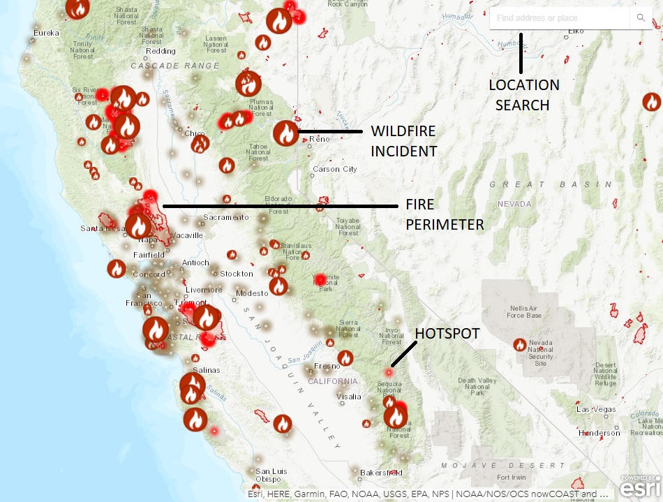
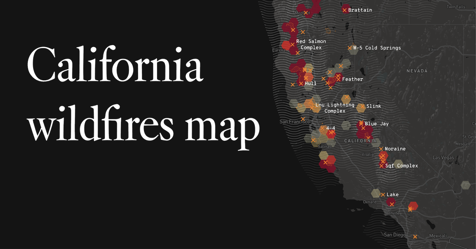
The smoke-filled skies and hushed emergency tones have become an unfortunate, recurring feature of the California landscape. For those planning a visit or a more extended stay, understanding the reality and patterns of wildfires is crucial for a safe and enjoyable experience. This isn’t about fear-mongering, but about informed preparation and a deeper appreciation for the resilience of this magnificent state. While the specter of wildfire is ever-present, particularly during the dry summer and fall months, pinpointing “where” the fires are is a dynamic question that requires ongoing attention and a nuanced understanding of the factors at play.
Understanding California’s Wildfire Landscape
California’s topography, climate, and vegetation create a unique environment where wildfires are a natural, albeit destructive, phenomenon. The state is a mosaic of ecosystems, from dense chaparral and coniferous forests to arid grasslands, each with its own susceptibility to ignition and spread. Understanding these ecological zones is the first step in grasping wildfire dynamics.
The Role of Climate and Weather
The most significant drivers of wildfire activity are climate and weather patterns. Prolonged periods of drought, high temperatures, and low humidity create tinderbox conditions across vast swathes of the state. The Santa Ana winds, hot and dry gusts that blow from the desert interior towards the coast, are particularly notorious for fanning flames and rapidly escalating wildfire behavior. These winds can transform a manageable blaze into an uncontrollable inferno in a matter of hours.
Fuel Load and Vegetation Types
The type and amount of vegetation, often referred to as fuel load, play a critical role in how fires ignite and spread. Chaparral, a dense shrubland common in Southern California, is highly flammable due to its oily leaves and woody structure. Coniferous forests, especially those with a history of fire suppression, can accumulate significant deadwood and undergrowth, providing ample fuel for large, intense fires. Grasslands, while appearing less threatening, can also burn intensely, especially when dry and interspersed with homes in the wildland-urban interface.
Human Influence and Ignition Sources
While natural causes like lightning strikes do initiate fires, a significant percentage are human-caused. These can range from carelessly discarded cigarettes and unattended campfires to equipment malfunctions, power lines, and arson. The increasing development in the wildland-urban interface (WUI) means more homes and communities are situated in areas prone to wildfires, escalating the risk to human life and property. Identifying high-risk areas often involves looking at historical fire data, vegetation density, and proximity to human activity.
Identifying High-Risk Regions and Seasons
While wildfire can occur anywhere in California, certain regions and seasons are consistently more prone to significant events. This isn’t to say other areas are entirely immune, but understanding these hotspots can inform travel plans and safety precautions.
Southern California’s Chaparral Country
Southern California, with its extensive chaparral ecosystems and often dry climate, is a perennial hotspot. Areas around Los Angeles, Ventura, Santa Barbara, and San Diego counties frequently experience large wildfires, especially during the fall and early winter months when the Santa Ana winds are most active. The mountainous terrain and steep canyons can also contribute to rapid fire spread.
Sierra Nevada and Northern California Forests
The vast forests of the Sierra Nevada and Northern California, including regions near Yosemite National Park, Lake Tahoe, and the Shasta-Trinity National Forest, are also susceptible, particularly during the summer and fall. These areas often experience larger, more intense fires due to the accumulation of fuel over years of fire suppression and the drier conditions that set in after the spring snowmelt.
The Central Valley’s Grasslands
While perhaps less dramatic than forest fires, the grasslands of the Central Valley can also experience significant fire activity, especially during exceptionally dry years. These fires, often driven by wind, can spread rapidly across open terrain and pose a threat to agricultural areas and communities bordering these open spaces.
Seasonal Patterns: Summer to Fall Dominance
The wildfire season in California has historically been most intense from late spring through fall. However, with changing climate patterns, warmer winters and earlier dry seasons are becoming more common, potentially extending the period of high risk. While lightning can spark fires year-round, the combination of extreme heat, low humidity, and dry vegetation makes the summer and fall months the most critical.
Navigating California with Wildfire Awareness
For travelers and residents alike, understanding the current fire situation is paramount. This awareness allows for informed decision-making, ensuring safety and minimizing disruption.

Staying Informed: Essential Resources
In an era of instant information, a wealth of resources is available to track wildfire activity. Knowing where to find reliable data is key.
Official Fire Agencies and Alerts
The California Department of Forestry and Fire Protection (CAL FIRE) is the primary state agency responsible for fire prevention and suppression. Their website and social media channels provide real-time updates on active fires, evacuation orders, and fire restrictions. The National Interagency Fire Center (NIFC) also offers broader national wildfire information. Local emergency management agencies and county sheriff departments are critical sources for evacuation alerts and community-specific information.
Air Quality Monitoring
Wildfires produce significant smoke, which can impact air quality far from the actual fire line. Websites and apps that monitor air quality, such as AirNow.gov, provide real-time Air Quality Index (AQI) readings, helping individuals make decisions about outdoor activities and respiratory health. Smog can be a significant concern in urban areas, but smoke from distant wildfires can also lead to unhealthy air conditions.
Planning Your Travel and Activities
If you’re planning a trip to California, especially during the peak fire season, a little foresight can go a long way.
Destination Research
Before booking accommodations or planning itineraries, research the specific regions you intend to visit. Look for recent wildfire activity and any ongoing fire restrictions in national forests or parks. Many park websites, like those for Yosemite National Park or Joshua Tree National Park, will post advisories regarding closures or fire impacts.
Flexibility and Contingency Plans
It’s wise to build flexibility into your travel plans. Wildfires can lead to road closures, park access restrictions, and advisories for air quality. Having alternative destinations or activities in mind can prevent disappointment and ensure you can still enjoy your time in California, even if your original plans are impacted. Consider booking accommodations with flexible cancellation policies.
Understanding Evacuation Zones
Familiarize yourself with the concept of evacuation zones, especially if staying in or traveling through known high-risk areas. Most areas have designated evacuation zones, and emergency services will issue evacuation orders and warnings through various channels. Knowing what these terms mean and how to receive these alerts is crucial for personal safety.
Wildfire Resilience and the Future of California Tourism
Despite the challenges posed by wildfires, California’s tourism industry and its natural beauty endure. The state is actively investing in fire prevention, suppression technologies, and community resilience programs.
Fire Prevention and Management Strategies
California employs a multi-faceted approach to wildfire management. This includes prescribed burns to reduce fuel loads, mechanical thinning of forests, and the use of advanced firefighting techniques and technologies. Early detection systems, including lookout towers and aerial patrols, are vital for rapid response.
Community Preparedness and Defensible Space
In communities located in the WUI, residents are increasingly encouraged to create “defensible space” around their homes – a buffer zone cleared of flammable vegetation. This proactive approach significantly increases a home’s chance of surviving a wildfire. Many communities also have ongoing efforts to update building codes to incorporate fire-resistant materials.
The Enduring Appeal of California’s Landscapes
While wildfire remains a concern, it is also a natural part of the California ecosystem. Many of the state’s most iconic landscapes, from the giant sequoias of Sequoia National Park to the rugged coastlines, are adapted to fire. Understanding and respecting this natural process, while taking necessary precautions, allows visitors to continue to experience the breathtaking beauty that draws millions to California each year. The key is to approach your visit with awareness, respect for the environment, and a commitment to safety.
LifeOutOfTheBox is a participant in the Amazon Services LLC Associates Program, an affiliate advertising program designed to provide a means for sites to earn advertising fees by advertising and linking to Amazon.com. Amazon, the Amazon logo, AmazonSupply, and the AmazonSupply logo are trademarks of Amazon.com, Inc. or its affiliates. As an Amazon Associate we earn affiliate commissions from qualifying purchases.