
Colorado, the Centennial State, is renowned for its dramatic landscapes, vibrant cities, and its unmistakable, geometrically precise outline on the map. This distinctive form is not a natural accident but a deliberate creation, deeply intertwined with the history of American expansion and the pursuit of order in a vast and wild territory. To understand the shape of Colorado, one must delve into the historical context of its creation, explore the geographical features that define its boundaries, and appreciate how this defined form influences its identity and the experiences it offers to visitors and residents alike.

The Rectangular Frontier: A Legacy of Straight Lines
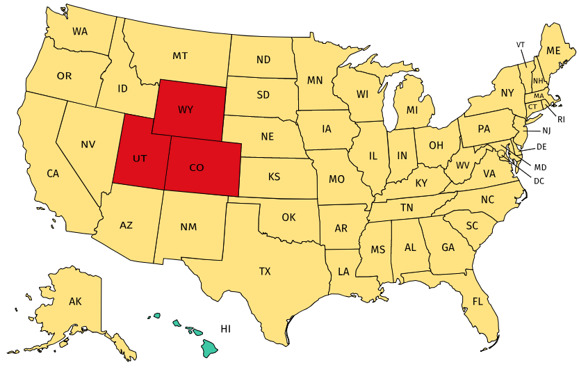
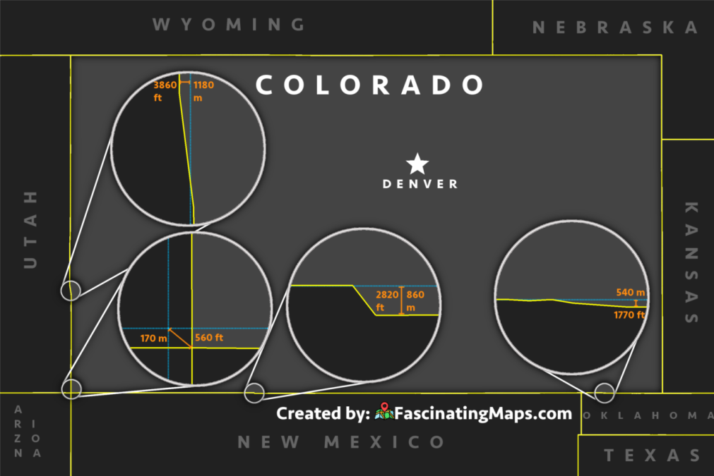
The most striking aspect of Colorado’s shape is its perfect rectangularity. Unlike many states whose borders follow natural features like rivers or mountain ranges, Colorado’s boundaries are almost entirely defined by straight lines of latitude and longitude. This characteristic is a direct result of its creation as a territory and subsequent state within the framework of the United States’ westward expansion.
The Genesis of a Rectangle
The story begins with the Kansas-Nebraska Act of 1854, which organized the territories of Kansas and Nebraska. The boundaries of these territories were largely defined by meridians and parallels, setting a precedent for the geometric division of the American West. As settlers moved into the Pikes Peak region in the late 1850s, leading to the Colorado Gold Rush, a movement for territorial government gained momentum.
In 1861, the U.S. Congress passed an act creating the Territory of Colorado. This act precisely defined its borders: the 37th parallel to the south, the 41st parallel to the north, the 102nd meridian west of Greenwich to the east, and the 109th meridian west of Greenwich to the west. This 38th parallel north and 41st parallel north, and the 102nd meridian west and 109th meridian west. This creation resulted in a rectangle measuring approximately 380 miles east-to-west and 270 miles north-to-south.
The Straight Line’s Significance
The decision to draw straight lines rather than follow natural contours was driven by several factors. Firstly, it represented a desire for clear, unambiguous boundaries in a rapidly expanding nation. Surveying and demarcation were more straightforward with geometric lines. Secondly, it reflected a vision of national unity and administrative order, where territories could be systematically carved out of the vast public domain. This approach contrasted with the older eastern states, whose borders often evolved organically around geographical features and colonial grants. The rectangular shape became a symbol of the planned, surveyed nature of American civilization imposing itself upon the landscape.
Defining the Edges: Geographical and Historical Markers
While the overarching shape is a rectangle, the specific geographical features and historical markers that delineate these straight lines add character and depth to Colorado’s borders. Each edge, though mathematically defined, has its own story and significant landmarks.
The Southern Boundary: The 37th Parallel
The southern border of Colorado is the 37th parallel north latitude. This line runs through diverse landscapes, including the arid plains of the southeastern part of the state and extending into the mountainous San Juan region. Historically, this boundary was also significant in the context of the Mexican Cession and the organization of territories following the Mexican-American War. A portion of this southern border also forms part of the boundary with New Mexico, a state with its own complex history and indigenous heritage.
The Northern Boundary: The 41st Parallel
The northern border of Colorado is the 41st parallel north latitude. This line separates Colorado from Wyoming. Much of this boundary traverses high plains and prairie landscapes, with fewer dramatic geographical features to mark the transition between states. It’s a testament to the power of cartographic precision in shaping political geography, creating a clear division across a relatively uniform terrain.
The Eastern Boundary: The 102nd Meridian West
The eastern border is the 102nd meridian west of Greenwich. This meridian runs through the high plains, defining the edge between Colorado and Kansas for much of its length, and then the edge between Colorado and Nebraska in the northeastern corner. This region is characterized by agricultural lands and open skies, where the straight line of the border is often the only visible marker of the state division.
The Western Boundary: The 109th Meridian West
The western border is the 109th meridian west of Greenwich. This line is perhaps the most geologically dramatic of Colorado’s straight-line boundaries. As the 109th meridian progresses southwards, it cuts through the rugged, mountainous terrain of the Rocky Mountains. This edge separates Colorado from the state of Utah. The “Four Corners” monument, a popular tourist attraction, marks the precise point where Colorado, Utah, Arizona, and New Mexico meet, a unique intersection of four states at a single geographical coordinate.
The Impact of a Geometric Form on the Landscape and Experience
Colorado’s rectangular shape, while an artificial construct, has had a profound impact on its internal geography, its development, and the experiences it offers.
Uniformity and Diversity
The geometric nature of its boundaries does not imply uniformity in its interior. Colorado is famously a state of immense geographical diversity, ranging from the arid plains of the east to the towering peaks of the Rockies and the dramatic canyons of the west. The straight lines of the border encompass this rich tapestry of landscapes, showcasing that even a geometrically defined state can contain extraordinary natural variety. This is particularly evident in the western half, where the Rocky Mountains dominate, creating a stark contrast with the eastern plains.
Resource Distribution and Development
The rectangular framework has also influenced how resources have been distributed and developed across the state. The eastern plains, rich in agriculture and some mineral resources, and the mountainous west, abundant in minerals, water, and tourism potential, are all contained within this single political entity. This has fostered a unique interdependency and a broad spectrum of economic activities that contribute to the state’s overall prosperity. The development of transportation networks, from early railroads to modern highways, has often been guided by the need to connect these diverse regions within the defined borders.
A Symbol of Identity and Exploration
For travelers, Colorado’s well-defined shape makes it an easily recognizable destination on any map. Its rectangularity lends itself to road trips and systematic exploration. Visitors can easily plan journeys that traverse its entirety, from the eastern plains to the western mountains, experiencing the full spectrum of what the state has to offer. The straight lines are not just arbitrary divisions; they are the framework upon which the narrative of Colorado’s natural beauty, outdoor adventures, and rich history is woven. Whether one is skiing in Aspen, hiking in Rocky Mountain National Park, exploring the historic mining towns, or enjoying the urban vibrancy of Denver, all these experiences are situated within the defined confines of this unique, rectangular state. The shape of Colorado is, therefore, more than just a cartographic curiosity; it is a historical artifact, a geographical canvas, and an integral part of its identity.
LifeOutOfTheBox is a participant in the Amazon Services LLC Associates Program, an affiliate advertising program designed to provide a means for sites to earn advertising fees by advertising and linking to Amazon.com. Amazon, the Amazon logo, AmazonSupply, and the AmazonSupply logo are trademarks of Amazon.com, Inc. or its affiliates. As an Amazon Associate we earn affiliate commissions from qualifying purchases.