
Idaho Falls sits as a crowning jewel in the high desert landscape of the Intermountain West. To understand its place on the map is to understand the geography of the Snake River Plain, a vast volcanic plateau that defines much of southeastern Idaho. Located in the heart of Bonneville County, this city serves as the primary gateway for travelers moving toward the wonders of the Greater Yellowstone Ecosystem.
Positioned roughly 280 miles east of Boise and just over 100 miles west of the border with Wyoming, the city acts as a vital hub for regional commerce and tourism. Its strategic location at the confluence of several major highways—most notably Interstate 15—makes it an essential stop for anyone trekking through the American West. Whether you are driving up from Salt Lake City or heading down from the northern peaks, you will find that the city is perfectly nestled between the rugged Rocky Mountains and the sprawling agricultural basins that feed the nation.
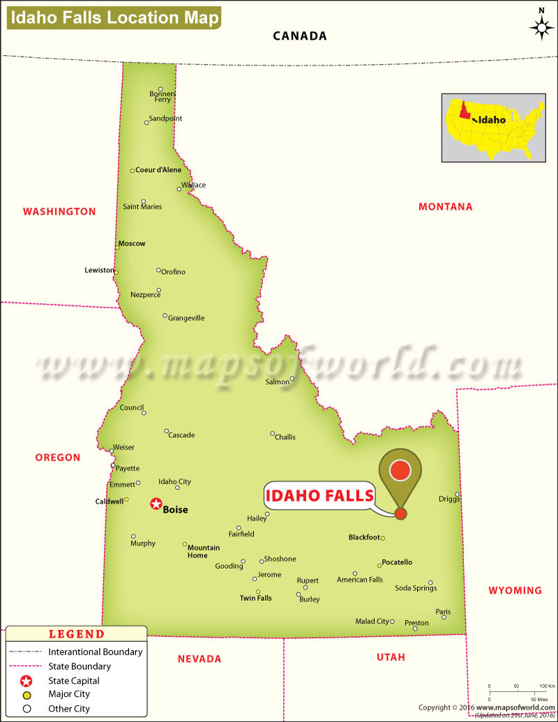
Geography and the Gateway to Adventure
The physical placement of Idaho Falls is not just a coordinate on a GPS; it is a landscape defined by the Snake River, which cuts directly through the urban core. This waterway serves as both the city’s namesake and its natural backbone, dictating the flow of the town’s layout and recreation.
The Influence of the Snake River
The Snake River does not merely pass through; it commands the aesthetic of the city. The famous Idaho Falls Greenbelt follows the winding banks of the river, providing a lush, linear park that connects the community to the water. This geological feature is essential to the region’s history, having provided the power and irrigation necessary for early settlers to establish a foothold in what was once considered inhospitable territory.
Proximity to National Landmarks
One of the most compelling reasons travelers pin Idaho Falls on their maps is its proximity to the world’s most famous national parks. Being situated approximately 100 miles from the west entrance of Yellowstone National Park makes this city an ideal base camp. Furthermore, the jagged peaks of the Grand Teton National Park in neighboring Wyoming are close enough for a spectacular day trip. By basing oneself here, travelers avoid the premium costs of staying inside the park boundaries while remaining within easy striking distance of the Geyser Basins and alpine trails.
Navigating the Regional Transit Hub
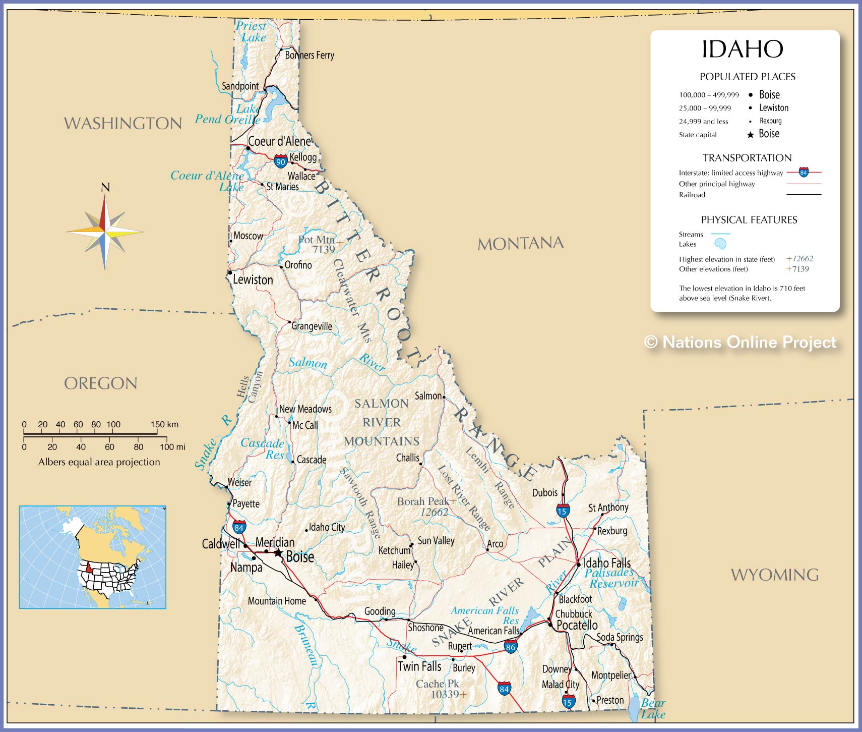
For those wondering how to best reach this location, the regional infrastructure is remarkably robust for a city of its size. The connectivity of the region is centered around access, ensuring that while you feel tucked away in the Rocky Mountains, you are never truly isolated.
The Role of Idaho Falls Regional Airport
The Idaho Falls Regional Airport serves as a critical node for travelers. It acts as the primary aerial gateway to southeastern Idaho, handling flights from major hubs across the United States. This makes the city far more accessible than its remote reputation might suggest. Business travelers and outdoor enthusiasts alike utilize this facility to bypass hours of mountain driving, landing directly in the heart of the region’s cultural and commercial activity.
Highways and Mountain Passes
If you prefer the classic road trip experience, the city is a masterclass in accessible transit. Driving along U.S. Route 20 or U.S. Route 26 offers panoramic views that are quintessential to the American West. These highways wind through vast plains and high-altitude valleys, ensuring that the journey to the city is just as scenic as the destination itself. Whether you are arriving from the lush valleys of Montana to the north or the arid, high-desert reaches of Utah to the south, the road network keeps you connected.
Why This Region Matters in the Mountain West
Beyond the simple “where,” it is worth considering the “why.” Idaho Falls is a city of transition. It marks the shift from the heavy industrial and technological sectors found in the Pacific Northwest to the outdoor, heritage-driven culture of the Mountain West.
A Hub for Science and Research
Not often highlighted by typical travel brochures is the city’s connection to the Idaho National Laboratory. While this facility is situated in the high desert to the west, its intellectual impact and economic footprint are felt throughout the city. This gives Idaho Falls a unique demographic makeup—a blend of agricultural tradition, adventurous tourism, and high-level scientific research. It is this intersection that gives the city its unique character, distinguishing it from smaller, purely tourist-dependent mountain towns.
Seasonal Transitions
The map of Idaho Falls changes with the seasons. In the winter, it is a gateway to the powder-heavy slopes of Grand Targhee Resort and Jackson Hole Mountain Resort. As the snow melts, the map shifts again, highlighting the legendary fly-fishing waters of the South Fork of the Snake River. This seasonal versatility ensures that, regardless of when you arrive, the geography remains relevant and engaging.

The Urban-Nature Synthesis
Finally, the city’s placement is a testament to thoughtful urban planning that respects its natural surroundings. While many cities are built to block out the landscape, Idaho Falls is built to facilitate access to it. By placing the city precisely where the river cascades over basalt lava flows, the founders ensured that nature would always be the defining feature of the local map. Walking the banks near the Civic Center or visiting the Museum of Idaho, one constantly feels the proximity to the wilder elements of North America.
As you trace your finger across the map of the Rocky Mountains, you will find that Idaho Falls occupies a singular, indispensable spot. It is the bridge between civilizations and the wilderness, a place where modern infrastructure meets the ancient, sweeping vistas of the American West. Whether you are passing through on a quest for the majesty of Yellowstone National Park or settling in to enjoy the local charm, you are standing at the heart of an extraordinary geographic crossroad.
LifeOutOfTheBox is a participant in the Amazon Services LLC Associates Program, an affiliate advertising program designed to provide a means for sites to earn advertising fees by advertising and linking to Amazon.com. Amazon, the Amazon logo, AmazonSupply, and the AmazonSupply logo are trademarks of Amazon.com, Inc. or its affiliates. As an Amazon Associate we earn affiliate commissions from qualifying purchases.