
When travelers think of New York, they often focus on the glittering concrete canyons of Manhattan or the rolling hills of the Catskills. However, understanding the geographic footprint of this iconic state is essential for any serious explorer. New York State serves as a bridge between the coastal culture of the Atlantic seaboard and the industrial heartland of the Great Lakes. Its borders are defined by a mix of natural waterways, historic treaties, and bustling international corridors.
To explore the perimeter of the Empire State is to witness the diversity of the American landscape, ranging from the rugged Adirondack Mountains in the north to the sandy shores of Long Island.
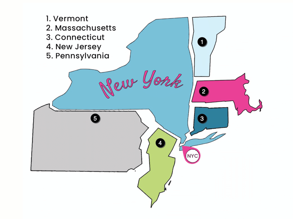
The Eastern Frontier: Atlantic Connections and New England Neighbors
The eastern edge of New York is a complex tapestry of state lines and deep-water access. Moving from north to south, the state shares a significant boundary with Vermont, a border largely defined by the pristine waters of Lake Champlain. This region is a haven for those interested in colonial history and the French and Indian War, as the strategic importance of the lake once made it a focal point for military campaigns.
Continuing south, New York meets Massachusetts and Connecticut. This border, particularly the portion shared with Connecticut, is notable for its proximity to the sprawling metropolitan region of New York City. Here, the suburban sprawl of Westchester County seamlessly transitions into the refined landscapes of New England. For travelers, this means the region is incredibly accessible via the Metro-North Railroad, allowing for easy day trips between the upscale towns of the Hudson Valley and the coastal charm of New England.
Maritime Borders and the Atlantic Ocean
At its southernmost point, New York loses its land borders and greets the vastness of the Atlantic Ocean. The Long Island coastline provides a dramatic terminus to the state, with Montauk Point acting as the easternmost tip. This maritime border is not just a geographic line; it is a cultural divide that defines the state’s relationship with maritime commerce, beach culture, and the seasonal migration of New Yorkers heading to the Hamptons.
The Northern Edge: An International Boundary
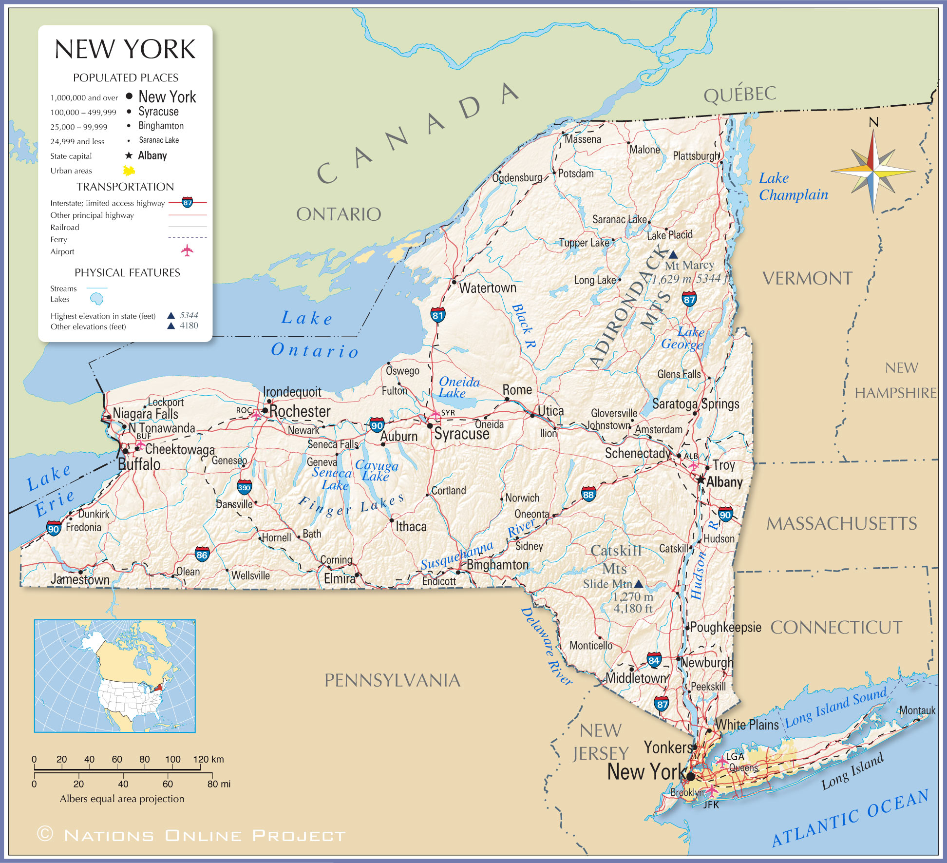
Perhaps the most distinct border defining New York is its northern international boundary with Canada. This line stretches from the St. Lawrence River in the west to the rugged forests near Quebec in the east. This is a border of immense geological and historical significance.
The St. Lawrence Seaway and Ontario
To the northwest, New York shares a water border with the province of Ontario, Canada. The St. Lawrence River is more than just a dividing line; it is a vital shipping artery that connects the Great Lakes to the world. Travelers visiting the Thousand Islands region will find that the border is often fluid, with boats frequently crossing between American and Canadian waters while exploring the historic mansions and natural beauty of the archipelago.
The Quebec Connection
Moving eastward, the New York border transitions into a land boundary with Quebec. This area is largely characterized by dense forests and the transition into the Appalachian Mountains. For the adventurous traveler, this region offers unique opportunities to experience the cultural blend of the North Country, where the influence of French-Canadian traditions meets the rugged, independent spirit of upstate New York.
The Western and Southern Boundaries: The Great Lakes and the Keystone State
The western and southern limits of New York are defined by a mix of massive inland seas and long-standing historical borders with Pennsylvania and New Jersey.
The Great Lakes Waterways
In the far west, New York shares a water border with Canada across Lake Erie and Lake Ontario. The connection between these two great bodies of water is, of course, the world-famous Niagara Falls. This is perhaps the most iconic border crossing in the entire state. The Niagara River serves as the international boundary, and the spectacle of the falls serves as a testament to the power of nature that transcends political divisions. Tourists flock here from both sides, creating a shared cultural experience that is mirrored in the sister cities of Niagara Falls, New York and Niagara Falls, Ontario.
The Border with Pennsylvania and New Jersey
The southern land border of New York is dominated by the line shared with Pennsylvania. This border runs east to west, cutting through the rolling hills and river valleys of the Southern Tier. It is a region defined by agricultural heritage and Finger Lakes viticulture, where the terrain remains largely consistent across the state line.
As you head further east toward the Atlantic Ocean, the border with New Jersey becomes heavily influenced by the Hudson River. This border is perhaps the most heavily trafficked in the United States, defined by the George Washington Bridge and the Lincoln Tunnel. These structures facilitate the daily movement of thousands of commuters, blurring the lines between the two states to the point where the New York City metropolitan area is often considered a singular economic entity regardless of the state boundary.

Conclusion: Understanding the Empire State’s Reach
From the quiet, tree-lined lakes of the Adirondacks to the bustling harbor of New York City, the borders of New York are a study in contrasts. They are formed by water, mountains, and the sheer momentum of human history. For the traveler, knowing these borders is not merely an academic exercise; it is a way to appreciate how the state interacts with its neighbors and how those interactions have shaped the identity of the region. Whether you are crossing a bridge into New Jersey, taking a ferry across Lake Champlain, or standing at the edge of Niagara Falls, you are engaging with the very lines that define the character of this remarkable place.
Understanding what borders New York provides a broader context for the journey, reminding us that no state exists in isolation. Each border crossing offers a change in pace, a shift in scenery, and an opportunity to see how the geography of the United States flows across lines drawn on a map.
LifeOutOfTheBox is a participant in the Amazon Services LLC Associates Program, an affiliate advertising program designed to provide a means for sites to earn advertising fees by advertising and linking to Amazon.com. Amazon, the Amazon logo, AmazonSupply, and the AmazonSupply logo are trademarks of Amazon.com, Inc. or its affiliates. As an Amazon Associate we earn affiliate commissions from qualifying purchases.