
Tucked away in the heart of New York Harbor, just a short ferry ride from the bustling streets of Manhattan and Brooklyn, lies Governors Island. For those unfamiliar with the geography of New York City, this 172-acre oasis can feel like a well-kept secret, hidden in plain sight between the skyscrapers of the Financial District and the residential shores of Red Hook. While it is technically part of the Borough of Manhattan, the island offers a distinctively tranquil escape, characterized by rolling hills, historical fortifications, and panoramic views of the Statue of Liberty.
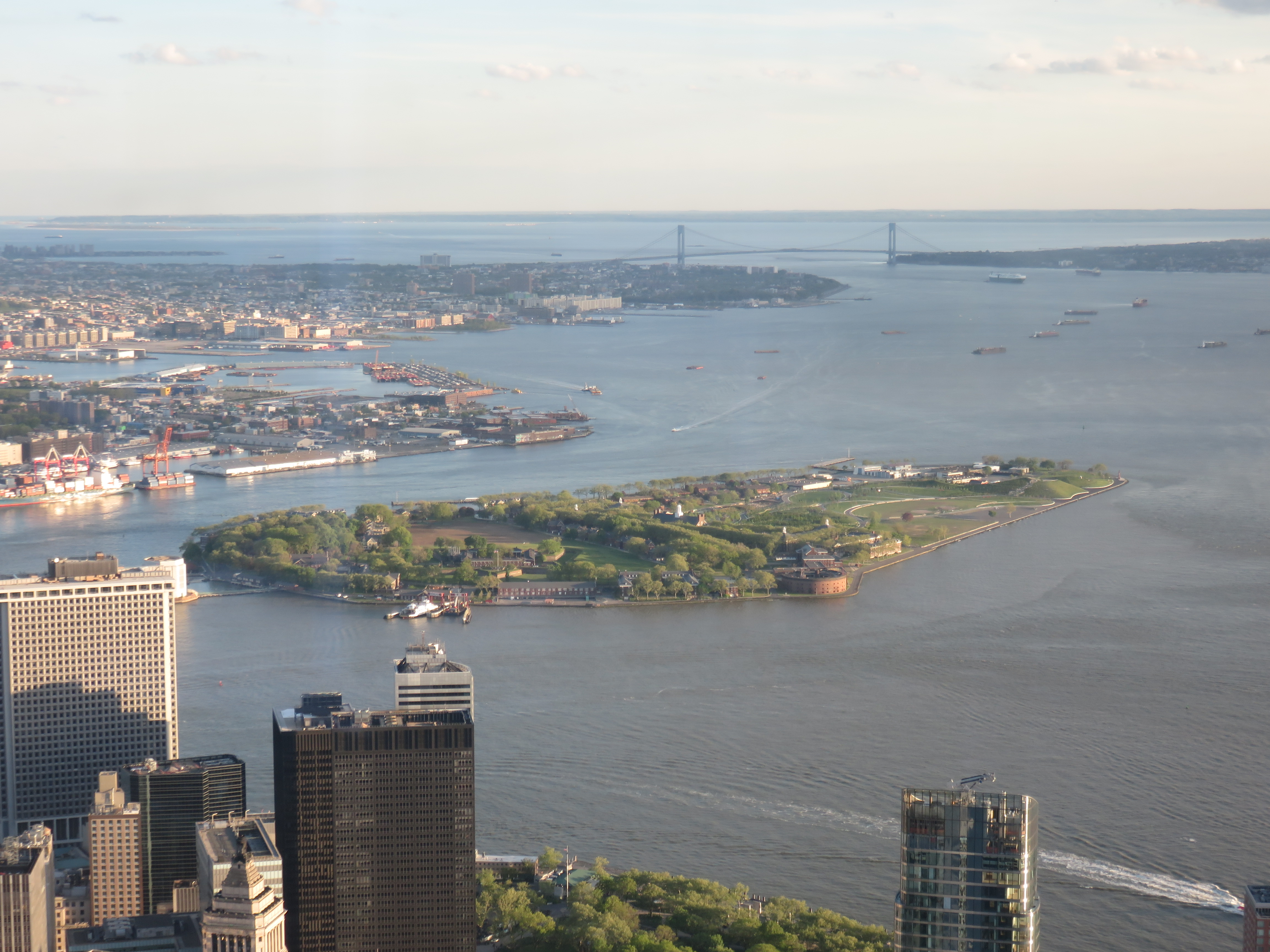
Locating the Island in New York Harbor
Governors Island is situated approximately 800 yards south of the southern tip of Lower Manhattan. Its strategic position at the confluence of the Hudson River and the East River made it a vital military post for centuries, but today, its location serves a different purpose: providing a lush, recreational sanctuary for millions of New Yorkers and visitors.
Geographic Coordinates and Proximity
The island sits directly across the Buttermilk Channel from Brooklyn. Because of this central placement, the island acts as a floating viewing platform. From its southern perimeter, visitors can look out toward Jersey City and the New Jersey coastline, while the northern end provides an intimate perspective of the World Trade Center and the canyon-like streets of the Financial District.
Getting There: The Ferry Experience
Access to the island is exclusively via maritime transport. The primary departure point is the Battery Maritime Building at Slip 7 in Lower Manhattan. During the peak summer season, additional ferry routes often run from Pier 6 at Brooklyn Bridge Park and Atlantic Basin in Red Hook. The transit time is brief—typically less than ten minutes—making it an incredibly accessible getaway for those exploring the United States.
A Landscape of History and Transformation
The geography of Governors Island is defined by its two distinct sections: the historic National Monument area to the north and the expansive, modern parkland to the south. Understanding where you are on the island is essential for navigating its various historical and recreational offerings.
The Historic North
The northern half of the island is home to the Governors Island National Monument, managed by the National Park Service. This area includes the star-shaped Fort Jay and the imposing, circular Castle Williams. These landmarks are testaments to the island’s long-standing role in protecting the city from naval threats during the early 19th century. Walking through the Historic District, visitors will find remnants of military barracks and officers’ homes that speak to a time when this was a restricted military base.

The Modern South and The Hills
In stark contrast to the flat military grounds of the north, the southern portion of the island has been completely reimagined through modern landscape architecture. The centerpiece of this area is The Hills, a series of four man-made elevations that rise 70 feet above the water. These hills offer the highest vantage point on the island, providing a 360-degree view of the New York Harbor that includes Governor’s Island itself, Manhattan, Brooklyn, and even parts of Staten Island.
Strategic Importance in the Modern Cityscape
For the contemporary traveler, Governors Island is more than just a place on a map; it is a critical piece of the New York City cultural infrastructure. Its location allows it to serve as a bridge between the intense, high-energy environment of Wall Street and the creative, artisan communities found in neighborhoods like Dumbo and Cobble Hill.
A Green Lung for the Metropolis
Being surrounded by the water of the Upper New York Bay, the island experiences cooler breezes than the mainland. This, combined with the lack of cars, makes it a preferred destination for cycling, picnicking, and summer events. Its geography allows for the creation of unique environments like Hammock Grove, where the natural landscape provides a sensory contrast to the concrete surrounding the City Hall area of Lower Manhattan.
Accessibility and Seasonal Flow
While the island was once closed to the public—having served as an Army base and later a Coast Guard station—it is now seasonal. It typically opens its ferry terminals and park gates in the spring and closes them in the late autumn. Understanding this seasonal accessibility is vital for anyone planning a trip, as the island undergoes a quiet transformation during the winter months when the ferry service is suspended.
Navigating the Island Like a Local
To truly grasp the scale and location of Governors Island, the best approach is to explore its perimeter on two wheels. A loop of the island allows you to see exactly where you are in relation to the Brooklyn Bridge to the north and the Verrazzano-Narrows Bridge in the distance to the south.
Key Orientation Landmarks
- The Parade Ground: This massive open field sits at the center of the island and serves as a natural anchor for orientation. It connects the historic military district to the newer park developments.
- Liggett Terrace: Located near the island’s mid-section, this area is a hub for food vendors and public art installations, effectively acting as the “downtown” of the island.
- Outlook Hill: This is the most prominent of the hills, serving as the ultimate landmark for anyone trying to find their bearings while navigating the pathways.

The Connectivity of the Harbor
Visitors often comment on how surreal it is to be in the middle of New York Harbor, watching the Staten Island Ferry glide past while being surrounded by the quiet hum of trees and coastal grasses. The location of the island forces a change in pace. By removing oneself from the New York City grid and placing oneself on this island, you gain a unique perspective on the architecture and density of the surrounding boroughs. Whether you arrive from the Battery Maritime Building or from a Brooklyn terminal, the act of crossing the water is a reminder that Governors Island is a distinct world, safely nestled in the heart of one of the world’s most vibrant coastal regions.
LifeOutOfTheBox is a participant in the Amazon Services LLC Associates Program, an affiliate advertising program designed to provide a means for sites to earn advertising fees by advertising and linking to Amazon.com. Amazon, the Amazon logo, AmazonSupply, and the AmazonSupply logo are trademarks of Amazon.com, Inc. or its affiliates. As an Amazon Associate we earn affiliate commissions from qualifying purchases.