
The allure of the shimmering lights and endless entertainment of Las Vegas, Nevada, has long captivated travelers, particularly those from its neighboring state, California. For millions of Californians, a trip to “Sin City” is a rite of passage, a quick getaway, or a regular pilgrimage. The question of “how far” isn’t merely about miles; it encompasses the journey, the time, the mode of transport, and the overall travel experience that connects these two dynamic regions. This comprehensive guide delves into the distances, routes, and travel considerations, transforming a simple query into a detailed travel itinerary for your next adventure.

Understanding the Proximity: California and Las Vegas
While geographically distinct, California and Las Vegas share a unique symbiotic relationship, largely driven by tourism and accessibility. The vast majority of visitors to Las Vegas from California originate from the southern part of the state, given its closer proximity. However, travelers from Northern California also frequently make the journey, often opting for different routes or modes of transport due to the greater distances involved. The journey itself is a significant part of the experience, often traversing dramatic desert landscapes that are a stark contrast to California’s coastal cities or verdant valleys.
A Tale of Two Regions: Why the Journey Matters
The popularity of the California-Las Vegas corridor is undeniable. For residents of bustling metropolises like Los Angeles and San Diego, Las Vegas offers a convenient escape to a world of entertainment, fine dining, and relaxation. Conversely, Californians often utilize Las Vegas as a hub for exploring other parts of Nevada or even Arizona. Understanding the distance is the first step in planning any trip, as it dictates the required time commitment, potential stops, and the most suitable mode of transportation. It’s not just about getting from point A to point B; it’s about optimizing the journey to maximize the overall travel experience.
More Than Just Miles: Factors Influencing Travel
When people ask “how far,” they’re often implicitly asking about travel time, convenience, and cost. While the mileage provides a baseline, factors such as traffic conditions, time of day, day of the week, weather, and the chosen mode of transport significantly impact the actual duration and ease of travel. A seemingly short distance can feel endless in heavy traffic, while a longer route might be more pleasant and scenic. Therefore, calculating the “far-ness” involves a holistic consideration of these variables.
Key Routes and Distances
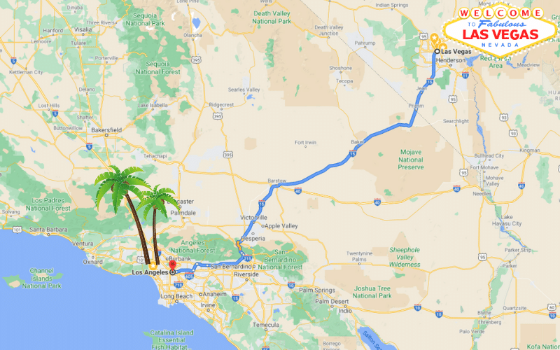
The primary mode of transport between California and Las Vegas for most travelers is by road, primarily via the well-trodden Interstate 15 (I-15). This freeway serves as the main artery connecting Southern California to the heart of Las Vegas. However, depending on the starting point in California, other routes and considerations come into play.
From Southern California: The I-15 Corridor
The vast majority of traffic heading to Las Vegas originates from Southern California, making the Interstate 15 the most iconic route.
- Los Angeles to Las Vegas: This is perhaps the most popular segment of the journey. From downtown Los Angeles, the distance to the Las Vegas Strip is approximately 270-280 miles (435-450 kilometers). Under ideal driving conditions, this trip typically takes 4 to 5 hours. However, due to notorious traffic congestion, especially on Friday afternoons, Sunday evenings, and holiday weekends, this travel time can easily extend to 6-8 hours or even longer. Key towns along this route include Barstow and Baker in California, before crossing into Nevada.
- San Diego to Las Vegas: Travelers from San Diego have a slightly longer journey. The distance is roughly 330-340 miles (530-547 kilometers), and the driving time usually ranges from 5 to 6 hours without significant delays. The route often involves taking Interstate 215 north to connect with the I-15 near Riverside or San Bernardino, then continuing on the I-15.
- The Desert Drive Experience: Regardless of the starting point in Southern California, a significant portion of the drive is through the beautiful and often stark Mojave Desert. This stretch offers unique landscapes, from vast open plains to distant mountain ranges. While seemingly barren, the desert offers its own kind of beauty and often features roadside attractions like the Seven Magic Mountains art installation near Las Vegas, or the historic Calico Ghost Town near Barstow, providing opportunities for scenic breaks.
From Northern California: Longer Journeys
For those originating from Northern California, the journey to Las Vegas is considerably longer and often warrants different travel planning.
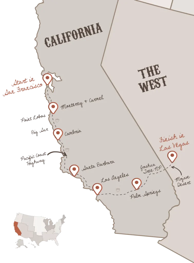
- San Francisco to Las Vegas: From San Francisco, the distance to Las Vegas is approximately 560-570 miles (900-917 kilometers). This extensive drive typically takes 9 to 10 hours of non-stop driving. Many travelers from this region opt to break up the drive with an overnight stay, or choose to fly. The most common driving routes involve heading south on Interstate 5 through the Central Valley before cutting east towards the I-15, or utilizing U.S. Route 395 for a more scenic, albeit slightly longer, journey through the Eastern Sierra Nevada and near destinations like Death Valley National Park.
- Alternative Northern California Routes: Depending on the specific starting point in Northern California, drivers might also consider routes that pass through Bakersfield or other inland cities before connecting to the I-15. These routes are generally long and require careful planning for fuel and rest stops.
Choosing Your Mode of Transport
The decision of how to travel between California and Las Vegas hinges on a combination of factors: budget, time constraints, comfort, and the number of travelers. Each mode of transportation offers a distinct experience.
Driving: Flexibility and Scenic Stops
Driving is, without a doubt, the most popular way to reach Las Vegas from California, especially from Southern California.
- Pros: Unparalleled flexibility to stop whenever and wherever you please, ideal for carrying luggage, cost-effective for groups, and the opportunity to discover roadside attractions. You control your schedule and pace.
- Cons: Susceptibility to heavy traffic, particularly on weekends and holidays, rising gas prices, and the potential for driver fatigue. Summer travel can mean extreme desert heat, putting a strain on vehicles and passengers.
- Tips: Travel during off-peak hours (mid-week, early mornings). Ensure your vehicle is in good condition, especially tires and fluids. Carry plenty of water and snacks. Consider breaking longer drives from Northern California into two days.
Flying: Speed and Convenience
For those prioritizing speed and avoiding the stresses of driving, flying is an excellent option, particularly from Northern California or if time is of the essence.
- Major Airports: Key departure points in California include Los Angeles International Airport (LAX), San Francisco International Airport (SFO), and San Diego International Airport (SAN). All flights arrive at Harry Reid International Airport (LAS) in Las Vegas.
- Flight Duration: The actual flight time is remarkably short: approximately 1 hour from Los Angeles or San Diego, and about 1.5 hours from San Francisco.
- Considerations: While quick, flying involves additional time for airport check-in, security, boarding, and baggage claim. Factor in travel time to and from airports, and the cost of airfare, which can fluctuate wildly depending on the season and booking lead time. Airlines like Southwest Airlines, Spirit Airlines, Delta Air Lines, United Airlines, and American Airlines offer frequent routes.
Bus Services: Economical and Stress-Free
Bus travel offers a cost-effective and relatively hassle-free alternative for solo travelers or groups who prefer not to drive.
- Operators: Companies like Greyhound and FlixBus offer regular services between various California cities and Las Vegas.
- Duration: Bus journeys are typically longer than driving due to multiple stops and adherence to strict speed limits. A trip from Los Angeles can take 5-7 hours, while from San Francisco, it could be 10-12 hours or more.
- Pros: Very economical, no need to worry about driving, gas, or parking. Many services drop passengers directly on or near the Las Vegas Strip or downtown.
- Cons: Less flexibility, longer travel times, and potentially less comfort compared to other options.
Train Travel: A Niche Option
While Amtrak does serve cities in California and Nevada, there is no direct train service to Las Vegas. Travelers would typically take a train to a city like Kingman, Arizona, or Needles, California, and then connect via a bus service. This makes train travel a less direct and often longer option for this specific route, generally appealing only to those seeking a unique rail experience rather than efficiency.
Planning Your Journey: Tips for a Smooth Trip
Regardless of how you choose to travel, a well-planned trip enhances the overall experience and minimizes potential stress.
Best Times to Travel
- Avoid Peak Hours: For driving, try to avoid departing Southern California on Friday afternoons (1 PM – 7 PM) and returning on Sunday evenings (2 PM – 8 PM), as these are notorious for heavy traffic on the Interstate 15. Holiday weekends are also extremely busy.
- Weather Considerations: The Mojave Desert experiences extreme heat in summer (June-August), with temperatures often exceeding 100°F (38°C). This can impact vehicle performance and comfort. Conversely, winter months can bring cooler temperatures and occasional, though rare, snow at higher elevations.
- Flight Deals: Airfare typically sees spikes during major holidays, conventions, and weekends. Booking in advance and being flexible with your travel dates can lead to significant savings.
What to Pack
Given the desert climate of Las Vegas, essential items include sunscreen, hats, sunglasses, and comfortable walking shoes for exploring the Las Vegas Strip and resorts. Even in the heat, many indoor venues are air-conditioned, so a light jacket or sweater is advisable for evenings.
Vehicle Preparation (If Driving)
Before embarking on a desert drive, ensure your vehicle is road-ready. Check tire pressure (including the spare), oil and fluid levels, and windshield wipers. Carry an emergency kit, jumper cables, and ample water, especially during warmer months. Cellular service can be spotty in certain remote stretches of the desert.
Budgeting for the Trip
Factor in all costs: gas, potential tolls (rare on the main I-15 route to Las Vegas but present on some California freeways), car rental, flights, bus tickets, and of course, accommodation, food, and entertainment in Las Vegas. Even a short trip can add up, so a clear budget is crucial.
Considering Stops and Detours
For those driving and with extra time, the journey itself can be part of the adventure. Popular stops on the I-15 include:
- Primm, Nevada, just across the border, known for its outlet shopping and roller coasters.
- The World’s Tallest Thermometer in Baker, California.
- The Calico Ghost Town near Barstow for a dose of Old West history.
- The colorful Seven Magic Mountains art installation, a short drive south of Las Vegas.
Beyond the Miles: The Experience of the Journey
The journey from California to Las Vegas is more than just covering distance; it’s a transition, a build-up of anticipation. The scenery transforms from urban sprawl to the majestic, open expanse of the Mojave Desert, culminating in the sudden appearance of the vibrant Las Vegas skyline.
The Desert Landscape
The desert offers a unique and often serene backdrop for the drive. Travelers witness incredible sunrises and sunsets painting the vast skies, and if lucky, might spot desert wildlife. This stretch provides a mental and physical space to decompress before diving into the high energy of Las Vegas.
Anticipation and Arrival
There’s a distinct moment, usually as you approach the city limits on the Interstate 15, when the bright lights of Las Vegas materialize on the horizon. This visual cue often signifies the official start of the vacation, building excitement and marking the end of the journey and the beginning of the experience.
Connecting Two Worlds
Ultimately, the routes connecting California and Las Vegas facilitate a constant flow of tourism, business, and cultural exchange between two of the most dynamic regions in the Western United States. While the question “how far” is quantitative, the answer reveals a rich tapestry of travel options, experiences, and cultural connections that make this journey a quintessential American road trip or a swift aerial escape.
In conclusion, the distance between California and Las Vegas varies significantly depending on your starting point, ranging from a manageable 270-mile drive from Los Angeles to a substantial 560-mile trek from San Francisco. However, with diverse transportation options and careful planning, the journey remains accessible and enjoyable, making Las Vegas an enduringly popular destination for Californians seeking excitement and escape.
LifeOutOfTheBox is a participant in the Amazon Services LLC Associates Program, an affiliate advertising program designed to provide a means for sites to earn advertising fees by advertising and linking to Amazon.com. Amazon, the Amazon logo, AmazonSupply, and the AmazonSupply logo are trademarks of Amazon.com, Inc. or its affiliates. As an Amazon Associate we earn affiliate commissions from qualifying purchases.