
Embarking on a journey across the United States is an experience filled with diverse landscapes, cultural discoveries, and significant logistical considerations. For many, understanding the vast distances involved is the critical first step in planning such an adventure. The question, “How far is Indiana from California?”, immediately prompts a broader exploration into the practicalities and possibilities of transcontinental travel. This isn’t merely a query about mileage; it’s an invitation to consider the time commitment, the mode of transport, the scenic routes, and the myriad experiences awaiting travelers who choose to traverse the heart of America.

Spanning over 2,000 miles, the distance between Indiana and California represents a significant cross-country endeavor, typically requiring multiple days of driving or several hours of flight time. This article delves into the specifics of this journey, offering insights for travelers contemplating such an ambitious trip, focusing exclusively on the travel aspects, from route planning to experiencing the journey itself.
The Geographical Divide: Quantifying the Distance
Understanding the precise distance between Indiana and California is foundational to any travel plan. This measurement, however, isn’t a single fixed number, as it depends heavily on the specific starting and ending points within these two large states, as well as the chosen mode of transportation.
Straight-Line vs. Driving Distance
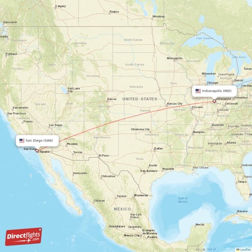
When considering the expanse between Indiana and California, it’s crucial to differentiate between the “as the crow flies” or aerial distance and the actual driving distance. The straight-line distance, which ignores road networks and geographical barriers, provides a theoretical minimum. For instance, the approximate aerial distance between major cities like Indianapolis, Indiana, and Los Angeles, California, hovers around 1,800 to 1,900 miles. This figure is useful for understanding the sheer scale but offers little practical guidance for ground travel.
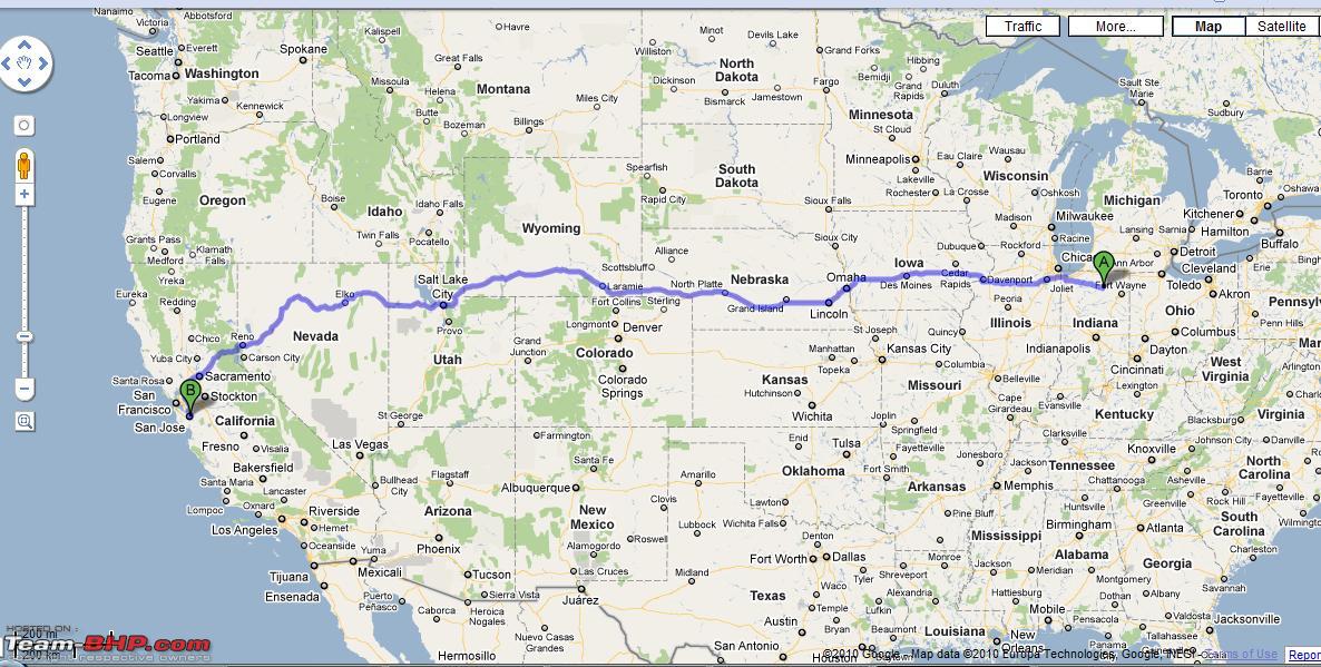
The driving distance, conversely, is what truly matters for road-trippers and those planning logistical movements. This measurement accounts for existing highways, interstates, and the winding nature of modern road infrastructure. Depending on the specific cities chosen within each state, the driving distance typically ranges from approximately 2,000 to 2,300 miles. For example, a journey from Indianapolis, Indiana, to Los Angeles, California, via the most common routes, can be around 2,000 to 2,200 miles. A trip from Fort Wayne, Indiana, to San Francisco, California, might push that closer to 2,300 miles due to slightly different geographical alignments and road networks. These variations underscore the importance of pinpointing specific destinations when calculating travel plans.
Understanding Travel Time Implications
Beyond the miles, the time required to cover this transcontinental stretch is paramount for travel planning. For drivers, the journey from Indiana to California is a multi-day undertaking. Assuming an average driving speed and accounting for necessary stops for fuel, food, and rest, the trip typically demands between 30 to 35 hours of active driving time.
Practically, this translates into a minimum of three to five days on the road. A “three-day push” would involve intense, long hours behind the wheel each day, often exceeding what is safely recommended for a single driver. A more leisurely and advisable pace would involve four or five days, allowing for 8-10 hours of driving daily, with ample time for breaks, meals, and overnight stays. Factors such as speed limits, traffic congestion (especially around major metropolitan areas like Chicago, Denver, or near California cities), construction, and adverse weather conditions can significantly impact the total travel duration. Planning for these variables is crucial to ensure a safe and enjoyable road trip.
Navigating the Journey: Travel Options and Logistics
Traversing the distance between Indiana and California offers several distinct travel options, each with its own set of advantages, challenges, and logistical considerations. The choice often depends on a traveler’s budget, time constraints, desired experience, and personal preferences.
Road Tripping Across America
The quintessential American road trip remains a popular choice for traveling between Indiana and California. This method offers unparalleled flexibility, allowing travelers to set their own pace, explore off-the-beaten-path attractions, and witness the stunning geographic diversity of the United States firsthand. Key interstates form the backbone of such a journey. Depending on the specific route chosen, travelers might utilize segments of I-70 through the Midwest, connecting to I-80 or I-40 further west. A common northern route might involve I-80 through Nebraska, Wyoming, and Utah, eventually leading to California. A central route could follow I-70 through Kansas and Colorado, then connecting to I-15 through Nevada.
Planning a successful road trip requires meticulous attention to detail. Vehicle maintenance is paramount; a thorough check-up before departure can prevent breakdowns far from home. Budgeting for fuel, meals, and overnight accommodation is also essential. Packing smart involves considering varying climates across multiple states, an emergency kit, and entertainment for long stretches. The allure of the road trip lies in the journey itself, with opportunities to stop at iconic landmarks such as the Gateway Arch National Park in St. Louis, explore the vibrant city of Denver, or experience the unique atmosphere of Las Vegas before reaching the Golden State.
The Efficiency of Air Travel
For travelers prioritizing speed and convenience, flying is undoubtedly the most efficient way to bridge the distance between Indiana and California. Non-stop flights between major airports like Indianapolis International Airport (IND) and Los Angeles International Airport (LAX) or San Francisco International Airport (SFO) typically take approximately 4 to 5 hours of actual flight time. With layovers, total travel time can range from 6 to 9 hours, including check-in, security, and boarding procedures.
Major carriers and several low-cost airlines operate routes connecting these regions, providing a range of price points and scheduling options. Booking flights in advance, particularly during off-peak seasons, can yield significant savings. While air travel drastically reduces transit time, it does come with its own set of considerations, including airport transfers, baggage fees, and the overall rigidity of flight schedules compared to the flexibility of a road trip. However, for business travelers or those with limited vacation time, flying remains the superior choice for covering such a vast distance.
Alternative Transportation: Rail and Bus
For travelers seeking a different pace, or who prefer to avoid driving or flying, alternative transportation options such as rail and bus services offer viable, albeit longer, journeys. Amtrak, the national passenger rail service, provides scenic routes that can connect Indiana to California. While there isn’t a direct line, travelers can typically depart from Indianapolis and connect via Chicago to major cross-country routes like the California Zephyr. This iconic train journey offers breathtaking views of the Rocky Mountains and the American West, turning the transit into an experience in itself. The total journey time by train can span two to three days, offering comfort, dining services, and the unique camaraderie of long-distance rail travel.
Bus services, such as Greyhound, also connect various cities between the two states. While generally the most economical option, bus travel is also the slowest, often taking upwards of two to three days, with multiple stops and transfers. Both rail and bus travel provide opportunities to relax, read, or work without the stress of driving, making them attractive for those who value the journey itself over strict time efficiency.
Planning Your Transcontinental Adventure
Regardless of the chosen mode of transport, a well-thought-out plan is the cornerstone of any successful cross-country trip between Indiana and California. Effective planning helps mitigate unforeseen challenges and enhances the overall travel experience.
Choosing Your Route and Pace
When planning a road trip, selecting the optimal route involves more than just finding the shortest distance. Travelers should consider their preferences for sightseeing, the time of year (which can affect weather conditions across different regions), and their overall budget. Three general corridors traverse the country:
- The Northern Route: Often involves I-80 and offers views of the Great Plains, Rocky Mountains in states like Wyoming, and eventually the deserts leading into California.
- The Central Route: Typically utilizing I-70, this path passes through Missouri, Kansas, and Colorado, before connecting to other interstates for the final leg to California. This route often offers a balance of scenic beauty and directness.
- The Southern Route: While less direct from Indiana, some travelers might opt to head south to connect with I-40 or I-10, especially if their final destination is in Southern California or if they wish to avoid colder weather during winter months.
Deciding on a pace is equally important. A frantic rush to cover ground quickly can lead to fatigue and missed opportunities for discovery. Allowing for 3-5 days of driving provides a more balanced approach, incorporating rest days or longer stops at points of interest. For air travel, selecting flights with convenient timings and minimal layovers can significantly improve the experience.
Essential Preparations for Long-Distance Travel
Thorough preparation is paramount. For drivers, a complete vehicle inspection—checking tires, oil, brakes, and fluids—is non-negotiable. An emergency kit with jumper cables, basic tools, first aid supplies, and non-perishable food and water can be a lifesaver. Smart packing involves layering clothing to adapt to varying temperatures across different states, alongside essential toiletries and personal medications. Digital tools, such as GPS navigation apps, weather forecasting apps, and booking platforms for accommodations, are indispensable resources for modern travelers. For flights, understanding baggage allowances, checking in online, and arriving early at the airport minimize stress. Regardless of the mode, ensuring all travel documents are easily accessible and notifying banks of travel plans can prevent unnecessary complications.
Bridging the Time Zones
The continental span between Indiana and California encompasses significant time zone differences, a crucial detail for planning arrivals and departures. Most of Indiana observes Eastern Time (ET), while California operates on Pacific Time (PT). This results in a three-hour time difference (e.g., 3 PM ET in Indiana is 12 PM PT in California). A small portion of southwestern Indiana observes Central Time (CT), making the difference four hours to PT.
This time shift impacts scheduling, especially for flights and any pre-arranged appointments upon arrival. Travelers flying westbound will essentially gain three hours, making the arrival feel earlier than expected, while those flying eastbound will “lose” three hours. While the impact of jet lag is generally less severe for domestic travel compared to international flights, understanding and mentally adjusting to the time change can help ease the transition.
Experience the Journey: More Than Just Miles
Traveling from Indiana to California is more than just covering a large distance; it’s an opportunity to immerse oneself in the diverse tapestry of the American landscape and culture. Each mile traversed opens a window to new experiences and perspectives.
Scenic Byways and National Parks
A cross-country journey offers unparalleled access to some of the nation’s most breathtaking natural wonders. Road trippers, in particular, can weave through various national parks and scenic byways. The plains of the Midwest transition into the majestic Rocky Mountains in Colorado and Utah, offering opportunities to detour to iconic sites like Arches National Park, Zion National Park, or the awe-inspiring Grand Canyon. The journey continues through the vast deserts of Nevada before ascending into the diverse ecosystems of California, from the Sierra Nevada to the Pacific Coast. These natural highlights transform a simple drive into an unforgettable outdoor adventure, allowing travelers to witness the profound geographical evolution across the continent.
Cultural Highlights and Urban Explorations
Beyond nature, the route between Indiana and California is dotted with cities and towns, each boasting unique cultural identities, historical significance, and culinary delights. Travelers can stop in vibrant cities like St. Louis for its historical sites and barbecue, Kansas City for its jazz heritage, or Denver for its burgeoning arts scene and proximity to mountain adventures. Exploring local diners, historic districts, and regional museums provides an authentic taste of America, allowing for a deeper understanding of the country’s varied traditions and modern life. The food scene evolves with each state, offering everything from hearty Midwestern fare to Southwestern spices and the fresh, innovative cuisine of California.
The Transformative Aspect of Cross-Country Travel
Undertaking a journey of this magnitude is often a transformative experience. It challenges perceptions of distance, expands understanding of diverse cultures, and fosters a profound connection with the American landscape. Whether it’s the solitary reflection on endless highways, the shared laughter in a bustling airport, or the quiet contemplation of a sunset over the Grand Canyon, cross-country travel creates lasting memories. It’s an opportunity for personal growth, a test of endurance, and a celebration of the freedom to explore. The journey itself becomes an integral part of the destination, enriching the overall travel narrative with unique stories and broadened horizons.
Conclusion
The question, “How far is Indiana from California?”, reveals a distance of over 2,000 miles, translating to several days of driving or a few hours by plane. However, the answer extends far beyond mere numbers. It encompasses the strategic planning required for either a multi-day road trip filled with discovery, a swift and efficient air journey, or a leisurely scenic train ride. Each option presents a unique way to traverse the vast American landscape, offering distinct experiences and challenges. Ultimately, the journey from the heart of the Midwest to the Pacific Coast is an invitation to explore, to learn, and to witness the incredible diversity that defines the United States, proving that some distances are measured not just in miles, but in memories.
LifeOutOfTheBox is a participant in the Amazon Services LLC Associates Program, an affiliate advertising program designed to provide a means for sites to earn advertising fees by advertising and linking to Amazon.com. Amazon, the Amazon logo, AmazonSupply, and the AmazonSupply logo are trademarks of Amazon.com, Inc. or its affiliates. As an Amazon Associate we earn affiliate commissions from qualifying purchases.