
California, a land of stunning natural beauty, iconic landmarks, and vibrant culture, is also defined by its dynamic geology. Beneath its picturesque landscapes lies a complex tapestry of tectonic plates constantly in motion, making the Golden State synonymous with seismic activity. While smaller tremors are a daily occurrence, history records moments when the earth’s immense power has dramatically reshaped the state, leaving an indelible mark on its geography, infrastructure, and collective memory. Understanding the largest of these events is not merely a historical exercise; it’s crucial to comprehending the very foundation and resilience of this remarkable place.
The Great San Francisco Earthquake of 1906: A Defining Moment
When discussing the largest earthquake in California’s recorded history, one event unequivocally stands above all others: the Great San Francisco Earthquake of 1906. This catastrophic natural phenomenon, which struck in the early morning hours of April 18, 1906, remains the benchmark against which all other seismic events in the state are measured. Its profound impact extended far beyond the immediate destruction, altering the course of urban development, igniting seismic research, and embedding itself deep into the state’s identity. For many, the very word “earthquake” in California evokes images of this legendary disaster. It was a stark reminder that even the most bustling and innovative cities are ultimately at the mercy of immense natural forces.
The Magnitude and Its Epicenter
The Great San Francisco Earthquake is estimated to have had a moment magnitude of approximately 7.9, though some analyses place it as high as 8.3 on the older Richter scale, a testament to its colossal energy release. While its namesake city bore the brunt of the devastation, the earthquake’s epicenter was located offshore, just southwest of San Francisco, near the coastal town of Daly City. The rupture, however, was incredibly long, extending for nearly 300 miles along the San Andreas Fault, from San Juan Bautista in the south to Cape Mendocino in the north. This extensive rupture zone meant that communities across a vast swathe of California experienced significant ground shaking. The ground displacement was considerable, with horizontal shifts of up to 20 feet recorded in some areas. The sheer scale of this rupture is what made the 1906 event so uniquely powerful and destructive, affecting a region far larger than just the immediate urban core of San Francisco.
The Devastation: Fire and Fury
While the initial ground shaking caused immense structural damage to buildings, bridges, and infrastructure across the Bay Area and beyond, it was the subsequent fires that truly sealed the fate of San Francisco. Broken gas lines ignited widespread conflagrations, and severed water mains rendered firefighters largely helpless. For three days and nights, the city burned uncontrollably, consuming approximately 25,000 buildings across 4.7 square miles, including much of the downtown area. The combined effects of the earthquake and fire resulted in an estimated 3,000 deaths, making it one of the deadliest natural disasters in United States history. Over 225,000 people were left homeless in San Francisco alone, a staggering number given the city’s population at the time. The 1906 earthquake transformed San Francisco from a thriving metropolis into a landscape of rubble and ash, yet it also ushered in an era of unprecedented rebuilding and a deeper scientific understanding of seismic forces.
California’s Tectonic Tapestry: Why Earthquakes Are Inevitable
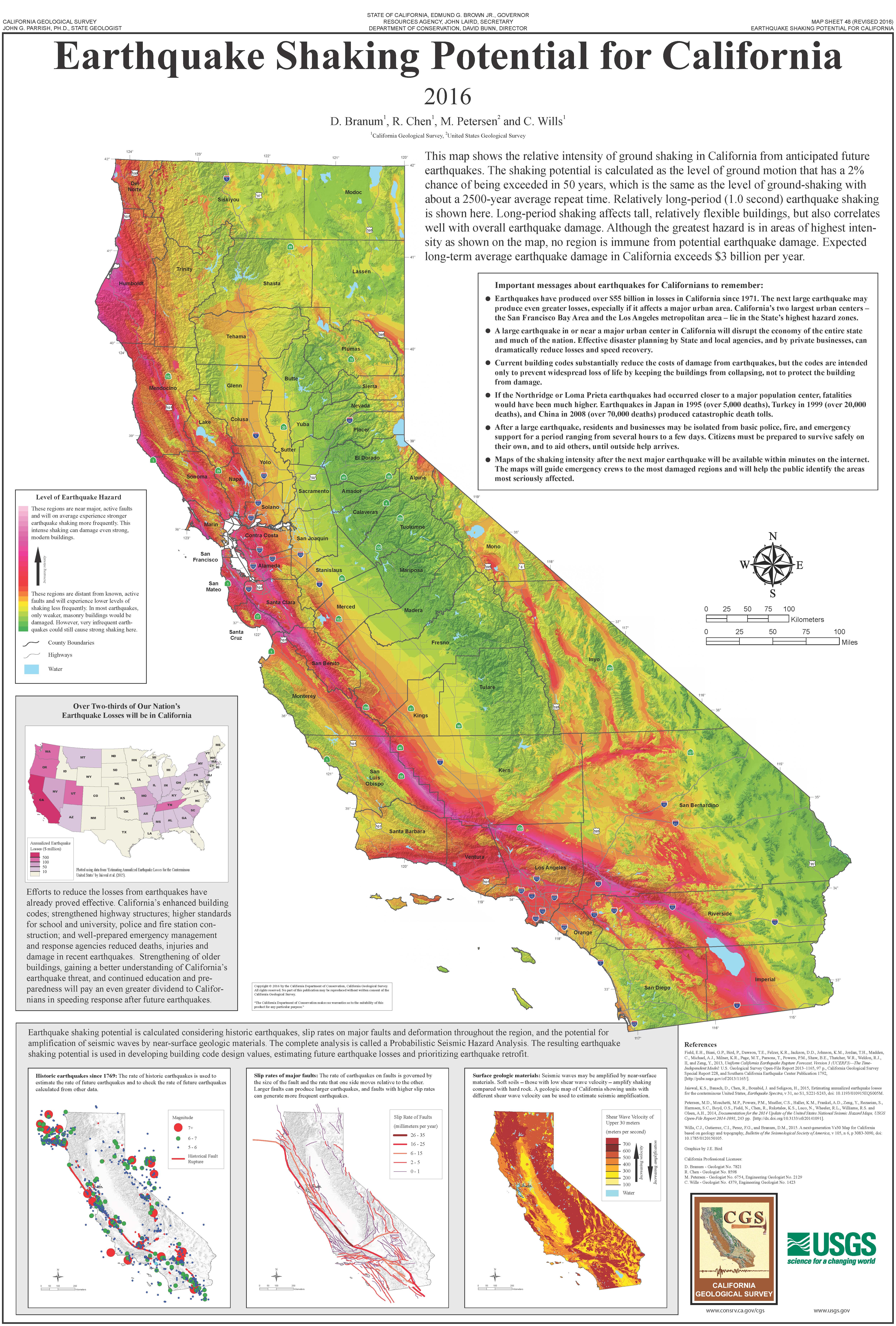
The dramatic events of 1906 are not an anomaly but a direct consequence of California’s unique geological position. Situated at the dynamic boundary between two of Earth’s largest tectonic plates, the Pacific Plate and the North American Plate, the state is a living laboratory of plate tectonics. This constant interaction, characterized by grinding, sliding, and occasional locking and slipping, generates the immense stresses that are ultimately released as earthquakes. Understanding this geological context is fundamental to appreciating why California is, and always will be, earthquake country. It’s a natural landmark in itself, a zone of immense geological activity that shapes everything from its mountain ranges to its valleys and coastal plains.
The San Andreas Fault: A Geological Giant
The most famous and formidable of California’s geological features is the San Andreas Fault. This right-lateral strike-slip fault system, stretching approximately 800 miles through California, marks the primary boundary where the Pacific Plate is grinding northwestward past the North American Plate. It’s not a single, continuous line but rather a complex zone of fault segments, some of which are “creeping” steadily, while others are “locked,” accumulating centuries of strain that will eventually be released in large, powerful earthquakes. The 1906 earthquake was a major release along a significant segment of the San Andreas Fault in Northern California, highlighting its immense capacity for destruction. Its visible scar across the landscape, in places, serves as a stark, enduring physical landmark of the tectonic forces at play.
Other Active Fault Systems
While the San Andreas Fault is the most well-known, California is crisscrossed by a multitude of other active fault systems, all contributing to the state’s seismic hazard. In Southern California, notable systems include the Garlock Fault, San Jacinto Fault, and the Northridge Fault (which caused the 1994 earthquake). In the Bay Area, other significant faults include the Hayward Fault, Rodgers Creek Fault, and the Calaveras Fault. Each of these systems has its own seismic history and potential for future activity, demonstrating that earthquake risk in California is not confined to a single linear feature but is a distributed, regional phenomenon. The presence of these multiple active fault lines means that nearly every major population center in California is exposed to some degree of seismic risk.
Understanding Seismic Activity
Seismologists continually monitor California’s fault lines, using sophisticated instruments to detect minute ground movements and analyze patterns of seismic activity. This ongoing research is critical for understanding earthquake mechanics, assessing rupture probabilities, and improving early warning systems. The scientific study of earthquakes, largely spurred by events like the 1906 quake, has transformed our understanding of the Earth’s interior and the forces that shape its surface. While predicting the exact timing of an earthquake remains impossible, advancements in seismology allow for better hazard mapping and risk assessment, which are vital for a state living on the geological edge. The pursuit of this knowledge is a modern marvel, born from ancient forces.
Beyond 1906: Other Significant California Quakes
While the 1906 earthquake holds the distinction of being the largest in California’s modern recorded history, it is far from the only significant seismic event to have impacted the state. Numerous other powerful quakes have punctuated California’s timeline, each leaving its own mark of destruction and contributing to the state’s evolving understanding of seismic preparedness. These events, though perhaps less iconic than 1906, are crucial landmarks in California’s natural history, reminding its residents and visitors alike of the persistent geological forces shaping this vibrant region. Each quake offers unique insights into fault mechanics and urban resilience.
The Tehachapi Earthquake of 1952

The Tehachapi Earthquake, which occurred on July 21, 1952, was a magnitude 7.3 quake that struck in the southern San Joaquin Valley, near the town of Tehachapi. It was the largest earthquake in Southern California in over 50 years and caused widespread damage, particularly to unreinforced masonry buildings. The quake triggered numerous landslides and ground ruptures, and tragically resulted in 12 fatalities. What made the Tehachapi Earthquake particularly notable from a scientific perspective was that it provided valuable data on how deep faults behave, stimulating further research into the complex fault systems underlying the southern part of the state, including the White Wolf Fault that was responsible for the main shock.
The Loma Prieta Earthquake of 1989
On October 17, 1989, a magnitude 6.9 earthquake struck the San Francisco Bay Area during Game 3 of the World Series, captivating a nationwide television audience. The Loma Prieta Earthquake was centered in the Santa Cruz Mountains and caused significant damage to infrastructure, most notably the collapse of a section of the Cypress Street Viaduct in Oakland and severe damage to the San Francisco-Oakland Bay Bridge. This event, which caused 63 deaths and thousands of injuries, exposed vulnerabilities in California’s infrastructure and led to major overhauls in building codes and retrofitting efforts, particularly for bridges and elevated highways. It was a critical turning point for modern seismic engineering.
The Northridge Earthquake of 1994
The Northridge Earthquake, a magnitude 6.7 quake, struck the San Fernando Valley north of Los Angeles on January 17, 1994. Despite its moderate magnitude compared to 1906, its shallow depth and location directly beneath a densely populated urban area resulted in unprecedented damage costs, estimated at over $20 billion. The quake was particularly destructive to residential structures, parking garages, and freeways, and revealed weaknesses in steel-frame construction. The Northridge Earthquake caused 57 deaths and significantly influenced seismic research into “blind thrust faults” — faults that do not break the surface, making them harder to identify and assess. This event profoundly shaped modern building codes in Southern California, pushing for more stringent seismic design.
Learning from the Earth: Building Resilience in the Golden State
The recurring seismic activity in California, epitomized by the 1906 earthquake, has fostered a unique culture of preparedness and innovation in the state. Rather than succumbing to the inevitable forces of nature, Californians have embraced the challenge, transforming geological vulnerability into an impetus for scientific advancement, engineering excellence, and community resilience. The state’s response to its seismic reality has become a landmark in itself, showcasing human adaptability and determination in the face of persistent natural threats. It’s a continuous process of learning, adapting, and reinforcing.
Seismic Engineering and Preparedness
Following devastating events like 1906, California has been at the forefront of developing advanced seismic engineering principles. Building codes are among the strictest in the world, mandating earthquake-resistant designs for new construction and encouraging retrofitting for older structures. Innovations like base isolation, shear walls, and flexible pipe systems are common features in modern California buildings and infrastructure, designed to withstand intense ground shaking. Furthermore, public awareness campaigns, emergency preparedness drills, and the development of early warning systems like ShakeAlert aim to educate residents and provide crucial seconds of warning before a major quake strikes, allowing for protective actions.
Historical Lessons and Urban Planning
The lessons learned from the 1906 San Francisco Earthquake, particularly regarding the dangers of fire following a quake and the vulnerability of certain types of construction, profoundly influenced subsequent urban planning. Cities across California have incorporated seismic considerations into their zoning laws and infrastructure development. The understanding of liquefaction — where saturated soil temporarily loses strength during an earthquake — has led to careful site selection for critical facilities and engineering solutions in vulnerable areas. The historical experiences of destruction have thus directly contributed to safer, more resilient communities.
Memorials and Educational Initiatives
The memory of the 1906 earthquake is preserved through various memorials and educational initiatives throughout California. In San Francisco, markers denote the extent of the fire, and museums like the California Academy of Sciences offer exhibits dedicated to earthquakes and geology. The United States Geological Survey (USGS) and academic institutions such as the University of California, Berkeley continue to lead groundbreaking research, educating future generations about seismic hazards and mitigation. These efforts ensure that the lessons from the state’s largest earthquake are never forgotten, serving as vital guides for living safely with the powerful forces of nature.
The Enduring Legacy of Seismic Activity
The largest earthquake in California’s history, the Great San Francisco Earthquake of 1906, is more than just a historical event; it is a fundamental part of the state’s natural and historical landscape. It demonstrated the immense power of the Earth and the profound vulnerability of human settlements, while simultaneously sparking a century of scientific inquiry and engineering innovation. The legacy of this and other significant quakes is woven into the very fabric of California’s identity, influencing everything from its building codes to its collective psyche.
California’s Geologic Identity
California’s dynamic geology is not merely a threat but also a defining characteristic that has shaped its remarkable landscapes. The fault systems, born from the same tectonic forces that cause earthquakes, are responsible for forming the stunning mountain ranges, fertile valleys, and dramatic coastlines that make California such an iconic place. The interplay of geological forces has created the rich, diverse natural landmarks that attract millions to the state, making seismic activity an intrinsic part of its unique allure and character.

A Landmark of Natural Power
Ultimately, the largest earthquake in California stands as a landmark of natural power—a historical event that profoundly impacted a famous place and continues to influence its development and resilience. It reminds us of the planet’s restless nature and the imperative to coexist intelligently with its forces. For those interested in the history and natural wonders of California, understanding this colossal event is essential to grasping the true essence of the Golden State, a place perpetually shaped by the movement beneath its feet.
LifeOutOfTheBox is a participant in the Amazon Services LLC Associates Program, an affiliate advertising program designed to provide a means for sites to earn advertising fees by advertising and linking to Amazon.com. Amazon, the Amazon logo, AmazonSupply, and the AmazonSupply logo are trademarks of Amazon.com, Inc. or its affiliates. As an Amazon Associate we earn affiliate commissions from qualifying purchases.