
California, a state synonymous with stunning coastlines, iconic cities like Los Angeles and San Francisco, and majestic national parks such as Yosemite and Sequoia, draws millions of travelers annually. Its diverse landscapes, from sun-drenched beaches to snow-capped mountains, offer an unparalleled range of experiences. However, amidst this splendor lies a recurring and increasingly severe challenge: wildfires. These infernos not only devastate natural ecosystems and communities but also significantly impact travel plans, safety, and the overall visitor experience. For anyone planning a trip to the Golden State, understanding “what’s causing California fires?” is not merely a matter of environmental curiosity but a crucial aspect of informed and responsible travel.
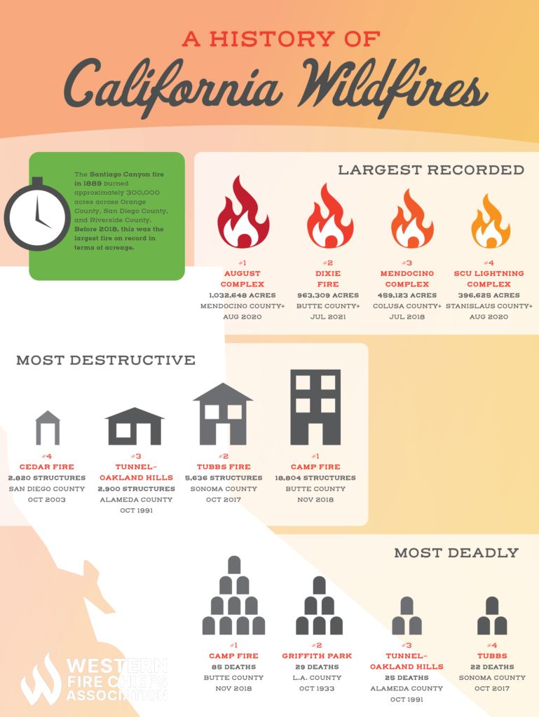
The causes of California’s wildfires are multifaceted, a complex interplay of natural conditions, human activities, and a changing climate. Dispelling misconceptions and delving into the science behind these events can empower travelers to make safer choices, support affected communities, and appreciate the delicate balance of this extraordinary destination. From the unique weather patterns that dry out the landscape to the history of land management and the undeniable influence of global warming, each factor contributes to a fire season that grows longer and more intense, reshaping how we explore and experience California’s natural wonders. This article aims to illuminate these causes, providing an insightful guide for travelers navigating the evolving landscape of California.
The Climatic Crucible: California’s Unique Weather Patterns
California’s Mediterranean climate, characterized by warm, dry summers and mild, wet winters, is a double-edged sword for travelers. While it provides ideal conditions for sun-seekers and outdoor adventurers for much of the year, it also inherently sets the stage for wildfire ignition and spread. Understanding these foundational climatic elements is key to appreciating the state’s natural fire vulnerability.
Prolonged Droughts and Dryness: Fueling the Fire Landscape
One of the most significant natural drivers of California’s wildfires is prolonged periods of drought. The state has experienced increasingly severe and frequent droughts in recent decades, leading to a dramatic reduction in moisture content across its vast wildlands. When rainfall is scarce, vegetation—from towering trees in the Sierra Nevada to dense chaparral in the coastal ranges—dries out, transforming into highly combustible fuel. This desiccated plant matter, including dead trees, fallen leaves, and dry grasses, creates an enormous fuel load, ready to ignite with the smallest spark. For travelers, this means that even seemingly lush areas can pose a significant fire risk during dry seasons. Hiking trails might be closed, certain campgrounds may be inaccessible, and the air quality can be severely impacted by distant blazes. Awareness of drought conditions, often indicated by fire danger ratings, should be a primary consideration when planning outdoor activities in areas like Big Sur or exploring the forests around Lake Tahoe. These dry conditions also contribute to dust and smoke, which can exacerbate respiratory issues for sensitive individuals, making it vital for travelers to check air quality reports before venturing out.
The Role of the Santa Ana Winds and Diablo Winds: The Firestorm Accelerators
Beyond dryness, California is notorious for its fierce, hot, and dry winds that can transform small blazes into uncontrollable infernos. In Southern California, these are the infamous Santa Ana Winds, typically occurring in autumn and early winter. Originating from high-pressure systems over the Great Basin, these winds gain heat and speed as they descend through mountain passes, funneling into coastal areas. Similarly, Northern California experiences the Diablo Winds (also known as North Winds) in the San Francisco Bay Area and North Bay, which bring similar desiccating and gusty conditions.
These powerful winds act as a merciless accelerant, pushing embers far ahead of the main fire front, starting new spot fires, and rapidly expanding the perimeter of existing blazes. They make firefighting incredibly challenging and contribute to the rapid spread that can quickly engulf large swaths of land, threatening entire communities and vital infrastructure. For travelers, high wind events often trigger red flag warnings, indicating extreme fire danger. During such times, travel through fire-prone canyons or mountainous regions, such as those leading to Palm Springs or along scenic routes like Highway 1, can become exceedingly dangerous, necessitating evacuations and road closures that can abruptly derail travel plans. Understanding the forecasting for these winds is crucial for any traveler contemplating a trip during California’s fire season, typically from late spring through fall.
Fueling the Flames: Vegetation and Land Management
While climate sets the stage, the type and abundance of vegetation, combined with historical land management practices, provide the actual fuel for California’s fires. The Golden State’s diverse ecosystems are naturally prone to fire, but human intervention has altered these patterns in ways that now contribute to larger and more destructive blazes.
Abundant Dry Biomass: The State’s Natural Combustibles
California is home to vast expanses of wildlands, each with its characteristic vegetation. The dense chaparral scrublands, particularly prevalent in Southern California and along the coast, are highly flammable, especially after a long, dry summer. These woody shrubs quickly dry out, turning into a tinderbox. Similarly, the state’s extensive forests, from the majestic redwoods of Humboldt County to the pine and fir forests of the Sierra Nevada, accumulate significant amounts of dead trees, branches, and leaf litter. This “fuel load” increases substantially during drought conditions and provides ample material for fires to consume, allowing them to burn hotter and spread further.
For visitors eager to explore California’s natural beauty, this abundance of dry biomass translates to inherent risks. Hiking trails through chaparral, camping in forested areas, or driving through dense woodlands all require a heightened awareness of fire danger. Many popular destinations, including areas around Santa Barbara, San Diego, and the vast national forests, are particularly susceptible. Travelers should always adhere to local fire restrictions, which often include bans on campfires, restrictions on vehicle access, and even temporary closures of parks and trails during periods of extreme risk. These measures are designed to protect both the public and the fragile ecosystems that make California such an attractive destination.
Historical Fire Suppression and Its Legacy: A Changed Landscape
For much of the 20th century, the dominant strategy for managing wildfires in the United States, including California, was aggressive fire suppression. The philosophy was simple: extinguish every fire as quickly as possible. While seemingly logical, this approach disrupted the natural fire cycles that many of California’s ecosystems evolved with. Historically, smaller, more frequent fires would clear out underbrush and smaller trees, preventing the accumulation of massive fuel loads.
The legacy of a century of fire suppression is an unnaturally dense and overgrown landscape. Forests that once saw regular, low-intensity burns now contain an unprecedented amount of fuel, leading to more destructive, high-intensity megafires that are incredibly difficult to control. These fires burn hotter, climb into the tree canopy, and are far more devastating to the ecosystem, destroying old-growth trees and impacting biodiversity. For travelers, this means that the risk of encountering a large, fast-moving wildfire has increased, especially in areas like the Shasta-Trinity National Forest or near communities nestled deep within the wildland-urban interface. Understanding this historical context helps explain why seemingly pristine wilderness areas can become dangerous so quickly and underscores the importance of ongoing efforts in prescribed burns and fuel reduction, which aim to restore a healthier, more fire-resilient landscape, ultimately making travel safer in the long run.
Human Impact: Ignitions and Urban Expansion
While natural conditions create the potential for fire, human activity is overwhelmingly the primary source of ignitions in California. Coupled with the state’s growing population and the expansion of communities into wildland areas, human factors significantly amplify both the frequency and severity of wildfires, presenting unique challenges for residents and travelers alike.
Accidental Ignitions: The Unintended Spark
A staggering majority of California’s wildfires are ignited by human activity. These ignitions range from the tragically negligent to the purely accidental. Common culprits include faulty power lines, which can spark fires when strong winds cause them to sway or drop onto dry vegetation. Equipment use, such as sparks from lawnmowers, grinding, or welding during dry periods, also contributes. Campfires left unattended or improperly extinguished, discarded cigarettes, vehicle malfunctions (like hot catalytic converters igniting dry grass), and even fireworks are frequent causes. Arson, while less common statistically, can also lead to devastating blazes.
For travelers, this means a heightened responsibility to exercise extreme caution, especially when venturing into natural areas. A simple act, like tossing a cigarette out a car window near Mendocino or setting off fireworks in a dry riverbed in Riverside County, can have catastrophic consequences. Many travel guides and park signs emphasize “fire safety,” and these warnings are not mere suggestions; they are critical directives. Knowing the current fire restrictions, using designated fire rings only when permitted, ensuring all fires are completely out, and being mindful of sparks from vehicles or equipment are fundamental aspects of responsible travel in California. Adherence to these guidelines protects not only the environment but also communities and fellow travelers, preserving the very landscapes we come to enjoy.
The Wildland-Urban Interface (WUI): Blurring the Lines of Risk
The rapid population growth in California has led to an increasing number of homes and communities being built in the “Wildland-Urban Interface” (WUI). This is the zone where developed areas meet or intermingle with undeveloped wildland vegetation. While these locations often offer stunning views and a connection to nature, they inherently place people and structures in direct proximity to fire-prone landscapes. When a wildfire ignites in the wildland, it can quickly spread to homes, and conversely, a structure fire can easily spread into the surrounding natural vegetation.
The expansion of the WUI complicates travel significantly during fire events. Roads serving these communities, often the same scenic routes cherished by tourists, become evacuation corridors. Fires in the WUI pose an immediate threat to life and property, leading to swift and widespread evacuations that can gridlock roads and shut down access to entire regions. For instance, a fire near Malibu or Sonoma County not only impacts residents but also closes major highways, displaces tourists from hotels, and directly threatens popular attractions and wineries. Travelers need to be particularly vigilant about understanding local geography and being aware of evacuation routes, especially if staying in vacation rentals or hotels located within or near WUI zones. Staying informed through local news and emergency alerts is paramount to ensuring a safe and uninterrupted travel experience when navigating California’s beautiful but increasingly fire-prone landscapes.
Climate Change: An Amplifying Factor for Future Travel
Undoubtedly, the most significant overarching factor exacerbating California’s fire problem is climate change. It acts as a force multiplier, intensifying existing conditions and pushing the state’s ecosystems into an unprecedented fire regime, with profound implications for how we will experience and travel through California in the coming years.
Warmer Temperatures and Extended Fire Seasons: A New Normal for Travelers
Global warming is leading to hotter average temperatures across California. Higher temperatures increase evaporation, drying out soil and vegetation more quickly and intensely than in the past. This means that the fuel loads mentioned earlier become even drier and more combustible, earlier in the season and for longer durations. Furthermore, warmer temperatures reduce snowpack in the mountains, which is a critical source of water for rivers, lakes, and soil moisture throughout the summer. A diminished snowpack means less water available to moderate fire risk once the warm season begins.
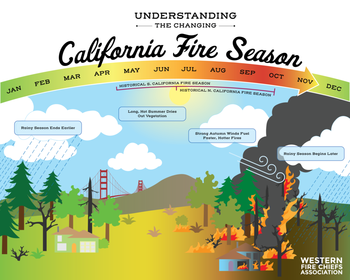
The direct consequence for travelers is an extended and more severe fire season. What was once primarily a late summer and fall phenomenon now often begins in late spring and can stretch into winter. This shift significantly impacts peak travel times, potentially disrupting plans for summer vacations to national parks or autumn winery tours in the Napa Valley. Air quality alerts due to wildfire smoke can become a more frequent occurrence, affecting outdoor activities and views from popular overlooks. Travelers must increasingly be prepared for the possibility of fire-related disruptions, even outside historically defined “fire season” windows, and factor this into their planning for any California adventure.

Adapting Travel Plans to a Changing Landscape: Resilience and Responsibility
Given the escalating impact of climate change on California’s wildfires, adaptation is becoming a critical skill for responsible travelers. This involves not only understanding the causes but actively incorporating fire awareness into every stage of travel planning. Checking current fire maps and local news before and during a trip is essential. Websites like CalFire provide real-time incident information, while air quality websites can help travelers avoid smoky areas. Being flexible with itineraries is also key, as road closures or park closures can occur with little notice.
Supporting local communities affected by fires, perhaps by visiting during off-peak times or choosing accommodations that contribute to local recovery efforts, is another way travelers can make a positive impact. Furthermore, engaging in sustainable travel practices—reducing carbon footprints, respecting natural resources, and adhering strictly to all fire safety regulations—contributes to the broader effort to mitigate climate change and protect California’s unique beauty for future generations. Traveling to California means experiencing its unparalleled landscapes, but it also means acknowledging its challenges. By understanding what drives these fires, travelers can contribute to safer experiences and support the resilience of this cherished destination.
LifeOutOfTheBox is a participant in the Amazon Services LLC Associates Program, an affiliate advertising program designed to provide a means for sites to earn advertising fees by advertising and linking to Amazon.com. Amazon, the Amazon logo, AmazonSupply, and the AmazonSupply logo are trademarks of Amazon.com, Inc. or its affiliates. As an Amazon Associate we earn affiliate commissions from qualifying purchases.