
California, a land of unparalleled natural beauty, vibrant cities, and diverse landscapes, is also a region frequently grappling with devastating wildfires. For travelers envisioning a trip to the Golden State, understanding the intricate reasons behind these fires isn’t just a matter of curiosity, but a crucial aspect of responsible and safe itinerary planning. The question of “why so many fires” unravels a complex tapestry woven from unique climatic conditions, geographical features, human actions, and the escalating impacts of climate change. Far from being a random occurrence, California’s fire problem is deeply rooted in its very essence, shaping its environment and influencing the travel experience for visitors worldwide.

The Golden State’s Unique Geography and Climate: A Recipe for Ignition
California’s distinct geographical and climatic characteristics create an environment inherently prone to wildfires. This natural predisposition is the foundational layer of its fire susceptibility, making it a critical consideration for anyone planning to explore its majestic landscapes.
The Mediterranean Climate: Hot, Dry Summers Are Key
At the heart of California’s fire dilemma is its Mediterranean climate, characterized by hot, dry summers and mild, wet winters. While these conditions are ideal for sun-seekers and agriculture, they also mean that by late summer and fall, the landscape is parched. The winter rains stimulate lush vegetation growth, but this greenery then dries out over the prolonged summer months, transforming into highly combustible fuel. This cyclical pattern of growth and desiccation is a fundamental driver of the state’s fire season, which now often stretches year-round. Tourists exploring destinations like Napa Valley or the coastal regions might encounter beautiful green hills in spring, only to find them golden-brown and bone-dry by August, a visual indicator of increasing fire risk.
The Role of Topography and Wind Patterns
California’s dramatic topography further exacerbates fire risk. Steep canyons, rugged mountains, and expansive valleys act as natural chimneys, funneling winds and accelerating fire spread. The Sierra Nevada Mountains, for instance, with their vast forestlands, present immense challenges for fire suppression due to inaccessible terrain.
Crucially, strong, dry winds are a notorious accelerant for California wildfires. The infamous Santa Ana winds in Southern California and the Diablo winds in Northern California are seasonal phenomena that push hot, dry air from inland deserts towards the coast. These winds strip moisture from vegetation, carry embers over vast distances, and can turn a small blaze into an inferno in a matter of minutes. For travelers, understanding the prevalence of these winds, particularly during late summer and fall, is vital for assessing localized risks and heeding any warnings or evacuation orders in areas like Los Angeles or San Francisco metro areas.
Fueling the Flames: Vegetation and Drought
The native vegetation of California is uniquely adapted to fire, and in many ways, thrives on it. However, centuries of fire suppression have led to an unnatural accumulation of fuel – dead trees, shrubs, and undergrowth – creating conditions for unusually large and destructive fires. The chaparral shrubland, oak woodlands, and extensive conifer forests (pines, firs, redwoods) that are characteristic of much of the state, especially popular tourist areas like Yosemite National Park or Sequoia National Park, become a tinderbox after months of dryness.
Adding to this volatile mix are persistent periods of drought. Prolonged drought significantly reduces the moisture content in vegetation, making it more susceptible to ignition and increasing the speed and intensity with which fires spread. The impact of drought is a critical factor amplified by climate change, further stressing forests and increasing tree mortality, thereby providing even more fuel for future fires.
Human Factors: Ignitions and Urban Expansion
While nature sets the stage, human actions often provide the spark that ignites California’s devastating wildfires. From accidental ignitions to deliberate acts, and the increasing proximity of human habitation to wilderness areas, the human footprint is undeniably a significant contributor to the frequency and scale of fires.
Unintentional and Intentional Ignitions
The vast majority of wildfires in California are human-caused. While lightning strikes do occur, especially in the northern parts of the state and the Sierra Nevada Mountains, human activities are responsible for approximately 95% of all ignitions. These can range from unintentional acts like sparks from faulty power lines, equipment malfunctions, discarded cigarettes, unattended campfires, and vehicle accidents, to intentional acts of arson. Even seemingly innocuous activities like fireworks or vehicle exhaust pipes touching dry grass can trigger a catastrophic blaze. For travelers, this highlights the immense responsibility everyone holds to prevent ignitions, especially when enjoying outdoor activities in national parks, forests, or even driving through rural areas. Adhering to fire restrictions, such as campfire bans or restrictions on specific equipment, is paramount for visitor safety and environmental protection.
The Wildland-Urban Interface (WUI)
A critical compounding factor is the expansion of the Wildland-Urban Interface (WUI). This is the zone where homes and communities are built at the edge of, or within, wildland vegetation. California’s population growth and the allure of living closer to nature have pushed development into historically fire-prone areas. As more homes are built in these vulnerable landscapes, the risk to human lives and property escalates dramatically. Fires that once burned naturally in remote areas without significant threat to human settlements now directly impact residential neighborhoods and critical infrastructure.
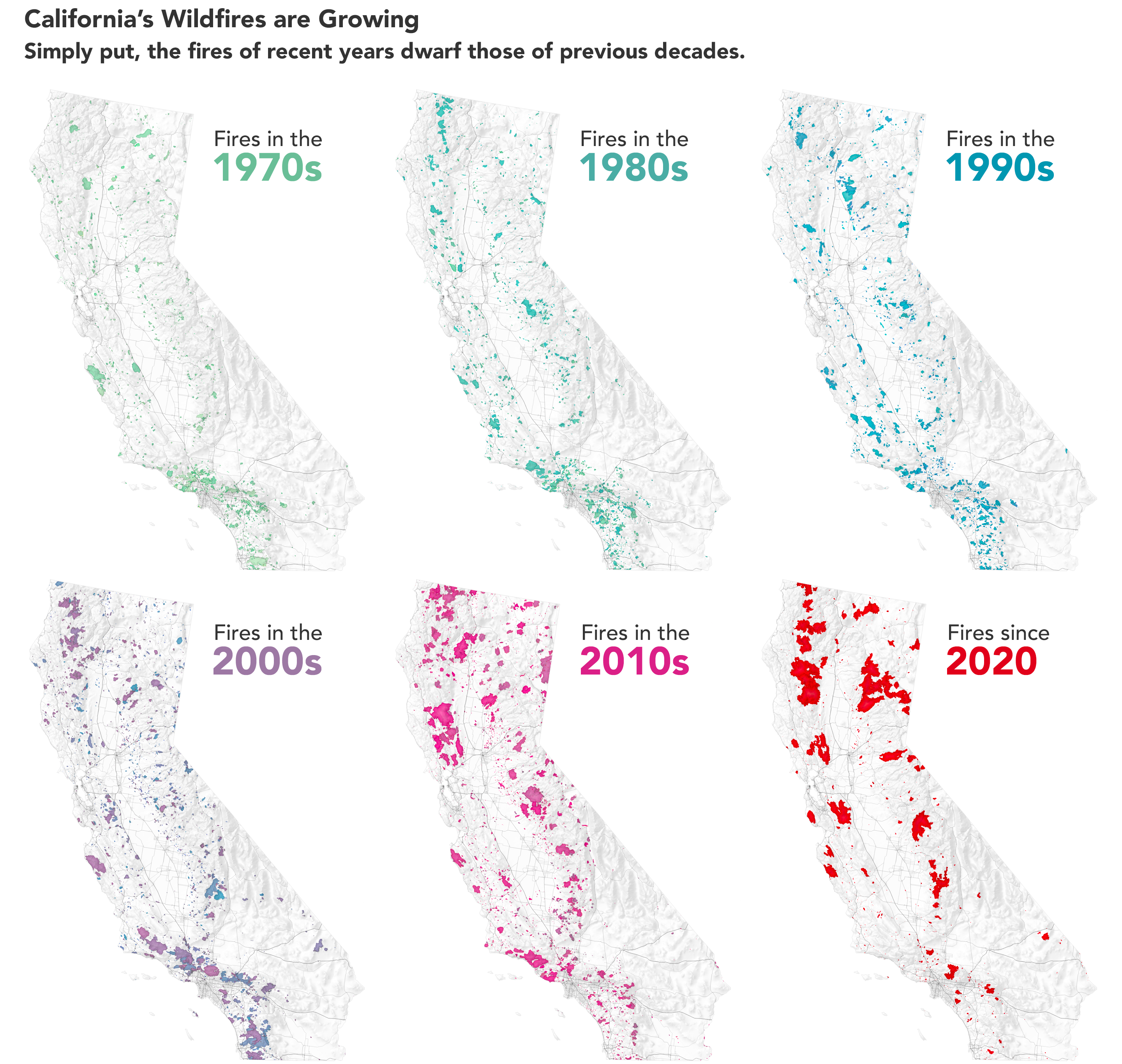
Travelers should be aware that many popular destinations, including scenic routes like portions of the Pacific Coast Highway near Big Sur or areas around Lake Tahoe, traverse or abut WUI zones. This proximity means that fire events can quickly lead to road closures, evacuations, and disruption of services, directly affecting travel plans and safety. The ongoing challenge for policymakers and communities is how to manage this interface responsibly, balancing development with the inherent risks of living in a fire-adapted ecosystem.
Climate Change: A Catalyst for Catastrophe
While natural conditions and human actions have long played a role in California’s fire history, climate change is now accelerating and intensifying the crisis, making wildfires larger, more frequent, and more destructive. This overarching factor fundamentally alters the fire landscape and demands increased awareness from travelers.
Prolonged Droughts and Higher Temperatures
Global warming is manifesting in California as persistent and intensifying droughts, coupled with record-breaking temperatures. Warmer air draws more moisture from the land and vegetation, exacerbating the drying process. This means that the “fire season” is no longer confined to a few months but has extended significantly, often lasting year-round. Higher temperatures also lead to reduced snowpack in the mountains, which is a vital source of water throughout the dry season. Less snowpack means rivers and reservoirs are replenished less, increasing water stress on vegetation and communities. For travelers, this implies that the risk of wildfires is a consideration for trips planned at almost any time of the year, particularly when venturing into the state’s natural parks and forests.
Forest Health and Insect Infestations
Droughts and rising temperatures weaken California’s forests, making them more susceptible to insect infestations, particularly bark beetles. These beetles thrive in stressed trees, killing vast tracts of forestland. These dead trees then become immense sources of fuel, drying out and standing ready to ignite. Areas like the Sierra Nevada Mountains have seen millions of trees succumb to this combination of drought and pest infestation, transforming healthy forests into prime kindling. This phenomenon not only increases fire risk but also fundamentally changes the ecology of these iconic natural destinations.
Navigating California During Fire Season: A Traveler’s Perspective
For those planning to experience the wonders of California, understanding the reality of wildfire season is crucial for a safe and enjoyable trip. It’s not about avoiding California, but about traveling smart and being prepared.
Planning Your Itinerary Safely and Flexibly
Travelers should always check current fire conditions before and during their trip. Resources from agencies like CAL FIRE provide real-time updates on active fires, containment levels, and evacuation orders. It’s also wise to monitor air quality indices (AQI), as smoke from distant fires can significantly impact air quality even in major cities like San Francisco or San Diego, affecting outdoor activities and overall comfort.
When booking accommodations or activities, consider flexible cancellation policies. While it’s impossible to predict a fire, having the option to adjust plans can be invaluable. If your planned destination, such as a state park in Sonoma County or a specific trail in Yosemite National Park, is in or near a high-risk area, have alternative plans ready. Embrace spontaneity and be willing to pivot to a different region if conditions warrant.
Understanding Air Quality and Health Considerations
Smoke from wildfires contains fine particulate matter that can pose serious health risks, especially for individuals with respiratory conditions, children, and the elderly. Even for healthy adults, prolonged exposure can cause irritation, coughing, and shortness of breath. Travelers should use available tools to check local AQI levels, and if the air quality is poor, limit outdoor activities, keep windows closed, and use N95 masks if venturing outside. Many hotels and indoor attractions in affected areas will have air filtration systems, making them safer havens during smoky periods.
Adapting to Unexpected Changes
The dynamic nature of wildfires means that road closures, park closures, and even evacuation orders can happen quickly and with little notice. Always keep a full tank of gas, carry an emergency kit, and have a charged phone with important contacts. Heed all official warnings and evacuation directives immediately. Remember, the primary goal of fire management agencies is public safety. While it may disrupt your travel plans, compliance ensures your well-being and allows emergency responders to focus on their critical work. Consider purchasing travel insurance that covers fire-related disruptions, offering peace of mind and financial protection against unforeseen cancellations or changes.

Looking Ahead: Resilience and Responsible Travel
The challenge of wildfires in California is immense and ongoing. However, the state is actively investing in fire prevention, landscape management, and community resilience. For travelers, being informed and practicing responsible tourism is an integral part of navigating this reality. This includes adhering to “Leave No Trace” principles, respecting fire restrictions in parks and forests, and educating oneself about local conditions. Despite the challenges, California remains an extraordinarily beautiful and rewarding destination. By understanding the “why” behind the fires and traveling conscientiously, visitors can safely enjoy the Golden State’s many splendors while contributing to its long-term resilience.
LifeOutOfTheBox is a participant in the Amazon Services LLC Associates Program, an affiliate advertising program designed to provide a means for sites to earn advertising fees by advertising and linking to Amazon.com. Amazon, the Amazon logo, AmazonSupply, and the AmazonSupply logo are trademarks of Amazon.com, Inc. or its affiliates. As an Amazon Associate we earn affiliate commissions from qualifying purchases.