
The journey between Los Angeles and Santa Barbara represents one of the most quintessential coastal traverses in the United States. Often referred to as a gateway to the American Riviera, this route transitions from the sprawling urban energy of the second-largest city in California to the Mediterranean-style charm and relaxed pace of a premier seaside escape. Understanding the distance is not merely a matter of calculating mileage; it is about navigating the unique geography of the Pacific Ocean coastline and the logistical realities of Southern California travel.
Understanding the Distance and Geographical Layout
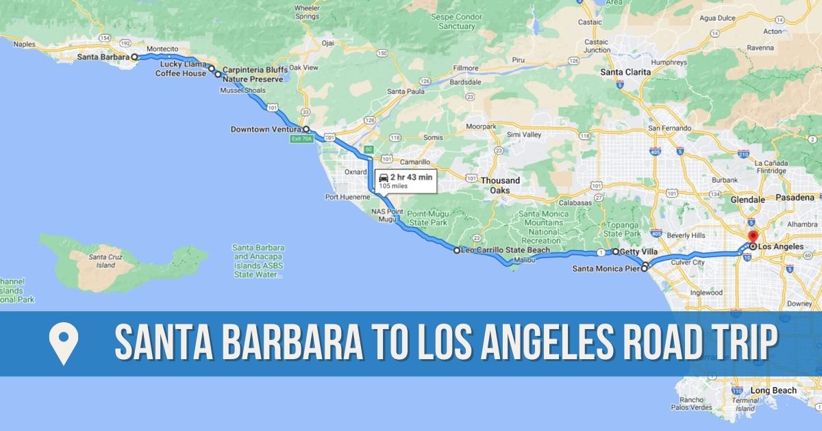
When travelers ask about the distance between these two iconic locations, the answer varies significantly depending on the chosen route and the specific point of departure. Generally, the straight-line distance is approximately 85 miles, but the actual road mileage usually ranges between 95 and 105 miles.
The Direct Distance vs. Driving Mileage
For those starting in Downtown Los Angeles, the most common path is a northwest trajectory. If you were to fly a drone directly to the Santa Barbara Station, you would cover less ground than a vehicle following the curves of the shoreline. In practical terms, most drivers find that the trip covers about 95 miles when utilizing the major freeway systems. However, if your journey begins in the southern parts of the Los Angeles basin, such as Long Beach or Santa Monica, the distance and travel time fluctuate accordingly.
The geography of the region is defined by the Santa Monica Mountains and the Santa Ynez Mountains, which squeeze the habitable land and transit corridors against the sea. This creates a narrow, high-demand travel path that is as beautiful as it is vital for regional commerce and tourism.
Navigating the Southern California Corridor
The transit corridor between these two hubs is primarily served by the US Route 101. This highway acts as the backbone of the trip, carrying travelers through the San Fernando Valley before descending toward the coast. The transition from the dense urban clusters of the valley to the open, agricultural, and coastal landscapes of Ventura County marks a psychological shift for the traveler. As the skyscrapers fade and the salt air begins to permeate the cabin, the physical distance feels shorter, even as the landscape expands.
Modes of Transportation: Choosing Your Path
While driving is the most common way to bridge the distance, several other modes of transport offer different perspectives on the California landscape. Each method alters the perceived distance based on the speed and the scenery provided.
Driving the Iconic Pacific Coast Highway
For those who prioritize aesthetics over speed, the Pacific Coast Highway, also known as Highway 1, is the premier choice. By taking this route, you exit the faster inland freeways and hug the cliffs of Malibu. While this adds only a few miles to the total distance, it can significantly increase the travel time due to lower speed limits and the inevitable desire to pull over for photographs.
Driving through Malibu allows travelers to witness the rugged beauty of Point Mugu State Park, where the mountains literally meet the surf. This route eventually merges back with the US Route 101 near Oxnard, but those first 30 miles of coastal driving are what many consider the true start of the journey to the Central Coast.
The Scenic Amtrak Pacific Surfliner Journey
For a completely different perspective on the distance, many travelers opt for the Amtrak rail service. The Pacific Surfliner departs from Union Station in the heart of Los Angeles and arrives at the historic Santa Barbara Station in approximately two and a half hours.
The rail distance is roughly the same as the driving mileage, but the experience is unparalleled. The tracks often run closer to the water than the highway, particularly through Ventura and Carpinteria. Passengers are treated to views of private beaches and hidden coves that are inaccessible by car. This mode of travel effectively eliminates the stress of traffic, making the 95-mile gap feel like a curated tour of the Golden State’s shoreline.
Private Shuttles and Ride-Sharing Logistics
For international visitors or those without access to a vehicle, private shuttles like the Santa Barbara Airbus provide a reliable link between Los Angeles International Airport and various stops in the Santa Barbara area. While ride-sharing services like Uber or Lyft are physically capable of making the trip, the cost can be prohibitive, often exceeding several hundred dollars depending on the time of day and vehicle class. However, for groups, the convenience of a door-to-door 100-mile transfer remains a viable luxury.
Key Stopovers and Points of Interest Along the Route
The distance from Los Angeles to Santa Barbara is punctuated by several significant landmarks and towns that make the journey part of the destination. Breaking up the trip allows travelers to appreciate the micro-climates and cultural shifts that occur over just a hundred miles.
Coastal Gems: Malibu and Ventura
Malibu serves as the first major milestone for those taking the scenic route. Home to Zuma Beach, this area offers a glimpse into the high-end coastal lifestyle of California. As you continue north, you enter Ventura, a city that retains a more classic, “old California” surf vibe. The Ventura Pier is a perfect midpoint stop, offering a chance to walk over the waves and stretch your legs before the final leg of the trip.
Between Ventura and Santa Barbara lies Carpinteria, known for its world-class tide pools and the Carpinteria State Beach. Even if you do not stop, the views of the Channel Islands on a clear day provide a majestic backdrop to the drive.
Mountain Vistas and Highway Transitions
For those remaining on the US Route 101, the climb over the Conejo Grade provides a dramatic change in elevation. Looking back toward the San Fernando Valley gives you a sense of the vastness of the Los Angeles metropolitan area, while the descent toward Camarillo opens up into expansive agricultural fields, showcasing the productivity of California farmlands.
Factors Influencing Travel Time
In Southern California, distance is often measured in minutes and hours rather than miles. A 95-mile trip can take anywhere from 90 minutes to four hours, depending on external variables.
The Impact of Los Angeles Traffic
The single greatest variable in the journey is the notorious Los Angeles traffic. Leaving the city during “rush hour”—which can span from 3:00 PM to 7:00 PM—can double the duration of the trip. The bottleneck often occurs as the US Route 101 passes through Encino and Woodland Hills. Once you clear the Ventura County line, the flow generally improves, but weekend travelers heading north on a Friday afternoon will find that the “distance” feels much greater than it appears on a map.
Seasonal Weather and Road Conditions
While the weather in this part of the United States is famously temperate, seasonal factors can influence the drive. During the late spring and early summer, the phenomenon known as “June Gloom” can bring thick fog to the Pacific Coast Highway, requiring slower speeds and more cautious driving. Additionally, winter rains can occasionally cause mudslides along the steep cliffs of the Santa Monica Mountains, leading to temporary closures of certain coastal roads and forcing all traffic onto the inland freeways.
Essential Travel Tips for the Journey
To make the most of the distance between Los Angeles and Santa Barbara, strategic planning is essential. Whether you are a local or a visitor, these tips ensure a smooth transition between these two world-class destinations.
Best Departure Times for a Smooth Trip
To experience the shortest travel time, seasoned travelers recommend departing Los Angeles before 7:00 AM or after 8:00 PM. On weekends, Saturday mornings are surprisingly manageable if you leave early. Conversely, returning to Los Angeles from Santa Barbara on a Sunday afternoon requires patience, as thousands of weekend warriors make the trek back south simultaneously.
Preparing for a Multi-Stop Coastal Adventure
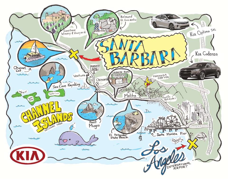
If time permits, treat the distance as a linear park. Pack a picnic to enjoy at Leo Carrillo State Park or plan a lunch stop in the Funk Zone once you arrive in Santa Barbara. By viewing the trip as a 100-mile experience rather than a 100-mile chore, the travel becomes the highlight of your California itinerary.
In conclusion, while the physical distance from Los Angeles to Santa Barbara is a fixed measurement of roughly 95 miles, the experience of the journey is dynamic. Through the lens of a traveler, it is a transition from the electric pulse of a global megacity to the refined tranquility of a coastal paradise—a journey that captures the very essence of the California dream.
LifeOutOfTheBox is a participant in the Amazon Services LLC Associates Program, an affiliate advertising program designed to provide a means for sites to earn advertising fees by advertising and linking to Amazon.com. Amazon, the Amazon logo, AmazonSupply, and the AmazonSupply logo are trademarks of Amazon.com, Inc. or its affiliates. As an Amazon Associate we earn affiliate commissions from qualifying purchases.