
To understand Louisiana, one must understand its water. While the Mississippi River serves as the state’s industrial heartbeat, the bayous represent its soul. These slow-moving, meandering streams and wetlands define the geography, culture, and history of the region. But for many travelers asking “where is the bayou in Louisiana?”, the answer is not a single point on a map, but a vast network of waterways stretching across the southern half of the state. These natural landmarks are more than just scenery; they are complex ecosystems that have shaped the lives of the people who call the Deep South home.
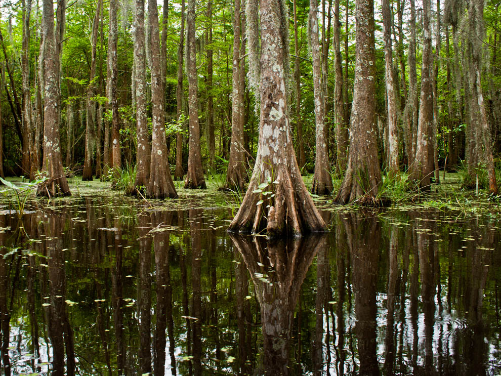
The Atchafalaya Basin: North America’s Largest River Swamp
The most significant concentration of bayous and swamp land is found within the Atchafalaya Basin. Located in south-central Louisiana, this is the largest river swamp in the United States. It is a sprawling landmark of biodiversity, encompassing nearly one million acres of bottomland hardwoods, cypress-tupelo swamps, and marshes.
The Geography of the Atchafalaya National Wildlife Refuge
At the heart of the basin lies the Atchafalaya National Wildlife Refuge. This protected area serves as a critical landmark for conservation efforts in North America. The bayous here are characterized by their “blackwater” appearance—darkened by the tannins of decaying vegetation—and are framed by ancient bald cypress trees draped in Spanish moss. This refuge is not just a landmark for nature lovers but a vital corridor for migratory birds and the Louisiana Black Bear. Navigating these waters requires a local guide, as the labyrinthine nature of the channels can be disorienting to the uninitiated.
Henderson and the Gateway to the Basin
For those seeking the quintessential bayou experience, the town of Henderson serves as the primary gateway. This small community is perched on the edge of the levee system that contains the Atchafalaya River. From the docks of Henderson, visitors can access the vast interior of the swamp. The area is famous for its “stilt houses” and the Whiskey Bay pilot channel, landmarks that illustrate how human habitation has adapted to a world that is more water than land.
Bayou Teche: The Cultural Mainstream of Acadiana
Moving slightly west of the central basin, one encounters Bayou Teche. Stretching 125 miles through the heart of Cajun Country, this waterway is perhaps the most historically significant bayou in the state. It was the primary means of transportation for early settlers and remains a landmark of the Acadian resilience.
Historical Significance of St. Martinville
The town of St. Martinville sits elegantly on the banks of Bayou Teche. It is home to the Evangeline Oak, a legendary landmark immortalized in Henry Wadsworth Longfellow poem. The bayou here is narrow and peaceful, lined with historic plantations and French-inspired architecture. This region, known as the Teche Corridor, offers a glimpse into a time when the bayou was the equivalent of a modern interstate highway, carrying sugar, cotton, and timber to market.
The Natural Beauty of Breaux Bridge
Further north along the Teche lies Breaux Bridge, often referred to as the “Crawfish Capital of the World.” The bayou here is a central part of the town’s identity. The Breaux Bridge Bridge is a historic landmark that provides a panoramic view of the slow-moving water. Nearby, Lake Martin offers one of the most accessible cypress swamps in the state, where the bayou spills into a shallow lake filled with herons, egrets, and alligators.
The Coastal Lifelines: Bayou Lafourche and Bayou Terrebonne
As you move toward the Gulf of Mexico, the bayous become larger and more essential to the state’s economy. This region is where the bayou culture is most visible in everyday life, as the waterways are crowded with shrimp boats, tugs, and oil service vessels.
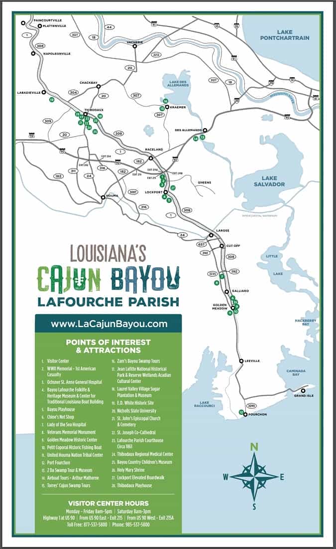
Bayou Lafourche: The Longest Main Street in the World
Bayou Lafourche is a unique landmark stretching over 100 miles from Donaldsonville down to the Gulf of Mexico. It is famously nicknamed “The Longest Main Street in the World” because the communities are built in a continuous line along its banks. Driving along Louisiana Highway 1, which parallels the bayou, one passes through towns like Thibodaux and Golden Meadow. This bayou is a vital landmark for the American energy industry, as it serves as a primary artery for supplies heading to Port Fourchon.
Exploring the Wetlands of Houma
The city of Houma is a central hub for exploring the coastal bayous of Terrebonne Parish. Here, the transition from freshwater bayous to saltwater marshes is evident. The Southdown Plantation serves as a landmark museum, documenting the history of the sugar industry that relied on these bayous. In this region, the “bayou” is not just a stream but an entire way of life, where residents rely on the water for their livelihood, from crabbing to offshore work.
Greater New Orleans and the Eastern Swamps
While many visitors stay within the French Quarter, some of the state’s most interesting bayou landmarks are located just minutes from the city center of New Orleans.
Bayou St. John: An Urban Landmark
Located entirely within the city limits of New Orleans, Bayou St. John is a historic waterway that once connected the city to Lake Pontchartrain. Today, it is a protected landmark and a popular recreational spot. The banks are lined with historic homes and the Pitot House, an 18th-century landmark that showcases colonial architecture. Unlike the wilder bayous of the basin, Bayou St. John offers a tranquil, manicured look at Louisiana hydrology.
The Honey Island Swamp and Pearl River Ecosystem
On the eastern edge of the state, near Slidell, lies the Honey Island Swamp. This area is defined by the Pearl River, which creates a series of pristine bayous and sloughs along the border with Mississippi. It is considered one of the least altered river swamps in the United States. Landmarks here include the dense canopy of cypress trees and the mysterious legends of the Honey Island Swamp Monster, which have become a part of local folklore.
Preserving the Bayou: Jean Lafitte National Historical Park and Preserve
To truly understand where the bayou is in Louisiana, one must visit the Jean Lafitte National Historical Park and Preserve. This multi-site park is dedicated to preserving the natural and cultural history of the Mississippi River Delta.
The Barataria Preserve Landmark
Located in Marrero, the Barataria Preserve is perhaps the best place for a pedestrian to experience the bayou. The preserve features miles of wooden boardwalks that wind through hardwood forests, swamps, and marshes. It is a landmark of environmental education, where visitors can see alligators sunning themselves on logs and hear the call of the barred owl. The preserve protects 23,000 acres of wild Louisiana wetlands, offering a glimpse of what the landscape looked like before modern development.

Sustainability and the Future of Louisiana’s Waterways
The bayous of Louisiana are currently facing significant challenges. Coastal erosion and rising sea levels threaten the delicate balance of these landmarks. Organizations like the Coastal Protection and Restoration Authority are working on massive projects to divert sediment from the Mississippi River back into the dying marshes. Understanding the location of the bayou also means understanding its fragility. These landmarks are not permanent; they are shifting, living entities that require active management to survive.
In conclusion, if you are looking for the bayou in Louisiana, you will find it anywhere the land meets the water in the southern half of the state. From the urban banks of Bayou St. John to the wild reaches of the Atchafalaya Basin, these landmarks define the identity of the Pelican State. They are places of mystery, beauty, and incredible ecological importance, standing as a testament to the unique geography of the Gulf South. Whether you are exploring the Acadian Village in Lafayette or taking a boat through the Manchac Swamp, the bayou is never far away, offering a silent, slow-moving history of the land and its people.
LifeOutOfTheBox is a participant in the Amazon Services LLC Associates Program, an affiliate advertising program designed to provide a means for sites to earn advertising fees by advertising and linking to Amazon.com. Amazon, the Amazon logo, AmazonSupply, and the AmazonSupply logo are trademarks of Amazon.com, Inc. or its affiliates. As an Amazon Associate we earn affiliate commissions from qualifying purchases.