
The vast, open skies and distinctive geography of Texas’s northernmost region have long conjured images of a unique American frontier. This area, known colloquially and officially as the Texas Panhandle, possesses a name that is as evocative as its landscape, hinting at both its physical form and its historical role. But why precisely is this particular section of the Lone Star State referred to as a panhandle? The answer lies in a blend of cartographical description, geographical resemblance, and a touch of historical serendipity that collectively shaped its identity.
A Geographical Analogy: The Shape of Things
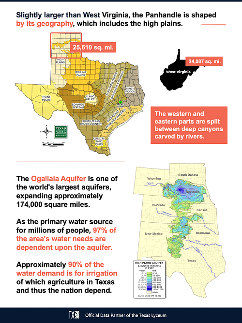
The most direct and widely accepted explanation for the moniker “Texas Panhandle” stems from its shape on the map. When viewed as a whole, Texas resembles a large, roughly rectangular state. However, extending northward from the main body of the state is a long, narrow strip of land. This protrusion, which juts significantly northward before meeting the border with Oklahoma, bears a striking resemblance to the handle of a frying pan.

The Pan’s Body and Handle
Imagine a frying pan lying flat. The main, broader section of Texas, encompassing cities like Houston, Dallas, and San Antonio, forms the bulbous body of the pan. Then, the elongated, northward extension, containing the cities of Amarillo, Lubbock, and Wichita Falls, clearly functions as the handle. This visual metaphor is so apt that it has become the universally recognized identifier for this distinct geographic and cultural region.
Cartographic Influence
The adoption of such a descriptive name is not uncommon in geography and cartography. Many regions and geographical features are named for their resemblance to everyday objects or natural formations. Just as the Great Lakes are a chain of large bodies of water, or the Rocky Mountains evoke rugged peaks, the “panhandle” designation for this part of Texas leverages a simple, relatable image to define a significant area. This clear, visual association made it an intuitive and enduring label.
Historical Roots and Boundaries
While the geographical resemblance is the primary driver, the history of how Texas‘s boundaries were defined also plays a role in understanding why this specific strip is so designated. The Texas Panhandle‘s northern boundary is largely defined by the 36°30′ parallel north latitude, a line that has historical significance in American territorial divisions.
The Compromise of 1850 and Land Claims
The modern boundaries of Texas were largely settled through a series of agreements and legislative actions in the mid-19th century. Following the Mexican-American War and the annexation of Texas by the United States, disputes arose over land claims and the extent of Texas‘s territory. The Compromise of 1850 was a pivotal moment, during which Texas ceded a significant portion of its western land claims, which now form parts of New Mexico, Colorado, Kansas, and Oklahoma, in exchange for $10 million.
Crucially, this compromise also helped solidify the northern boundary of what would become the Texas Panhandle. The land that remained within Texas‘s jurisdiction north of the main body formed the distinctive appendage. This historical land deal effectively created the geographical anomaly that the “panhandle” description so perfectly captures.
Early Exploration and Naming
While the exact moment the term “Texas Panhandle” was first coined is difficult to pinpoint, its usage became common as settlement and mapping efforts progressed in the late 19th century. Early explorers, surveyors, and settlers navigating this distinctive territory would have readily observed its peculiar shape relative to the rest of Texas. The descriptive power of the panhandle metaphor made it a natural choice for informal and later formal identification.
Beyond the Shape: A Region Defined
The “panhandle” designation is more than just a geographical descriptor; it signifies a region with its own unique identity, history, and culture, distinct from other parts of Texas. The landscape, economy, and even the character of its people are shaped by its location and history.
The High Plains and Their Influence
The Texas Panhandle is primarily characterized by its High Plains topography. This vast, relatively flat expanse has fostered a strong agricultural and ranching tradition, with cattle grazing and crop cultivation forming the backbone of its economy for generations. The wide-open spaces, the dramatic sunsets, and the resilient spirit of its inhabitants are all deeply intertwined with this environment.
Key Destinations and Attractions
Visitors to the Texas Panhandle will discover a region rich in historical sites and natural wonders that reflect its frontier past.
Palo Duro Canyon State Park: The “Grand Canyon of Texas”
Often referred to as the “Grand Canyon of Texas,” Palo Duro Canyon State Park is a breathtaking natural landmark. This immense canyon, carved by the Palo Duro Creek, offers stunning vistas, hiking trails, and a glimpse into the geological history of the region. Its scale and beauty are a testament to the raw, untamed nature that once defined this area and continues to inspire awe today.
Cadillac Ranch: A Quirky Icon
Near Amarillo, the Cadillac Ranch stands as a unique and iconic roadside attraction. Ten vintage Cadillac automobiles, buried nose-first in the ground, have become a canvas for graffiti artists from around the world. It’s a playful and eccentric symbol of the region’s blend of art, automotive culture, and a touch of the bizarre that often accompanies life on the open road.
Caprock Canyons State Park & Trailway: Bat Cave and More
Further south, Caprock Canyons State Park & Trailway offers a different but equally compelling natural experience. It is famously home to the Texas State Bat Cave, where visitors can witness the spectacular evening flight of millions of Mexican free-tailed bats. The park’s rugged canyons and diverse wildlife also make it a prime destination for outdoor enthusiasts.
Economic Landscape
The economic engine of the Texas Panhandle has historically been, and continues to be, driven by agriculture and energy. Vast ranches have long raised cattle, and the fertile plains support extensive farming operations. In more recent decades, the region has also become a significant player in wind energy production, harnessing the consistent winds that sweep across the High Plains. The Petro-Chemical industry also plays a vital role, particularly around Amarillo.
A Persistent Identity
The name “Texas Panhandle” has endured not just because of its descriptive accuracy, but because it has come to represent a distinct part of Texas with its own character. The people, the landscape, and the history all contribute to a sense of regional identity that is proud and independent. From the windswept plains to the dramatic canyons, the Texas Panhandle is a testament to how geography, history, and a simple, evocative name can come together to define a place. The next time you see Texas on a map, and your eyes are drawn to that elongated northern stretch, you’ll know precisely why it’s called the Texas Panhandle – a fitting name for a remarkable region.
LifeOutOfTheBox is a participant in the Amazon Services LLC Associates Program, an affiliate advertising program designed to provide a means for sites to earn advertising fees by advertising and linking to Amazon.com. Amazon, the Amazon logo, AmazonSupply, and the AmazonSupply logo are trademarks of Amazon.com, Inc. or its affiliates. As an Amazon Associate we earn affiliate commissions from qualifying purchases.