
California, a state of immense natural beauty and bustling urban centers, presents a unique challenge and opportunity for travelers when it comes to understanding distances. From its northern redwood forests to its southern deserts, and its iconic coastline to its towering mountain ranges, the Golden State spans a remarkable geographical area. Planning a trip here requires a keen awareness of how far apart attractions and cities are, as this directly impacts travel time, logistics, and the overall enjoyment of your journey. Navigating the diverse landscapes and extensive roadways of California efficiently is key to maximizing your exploration of this vibrant destination.
Understanding California’s Vastness
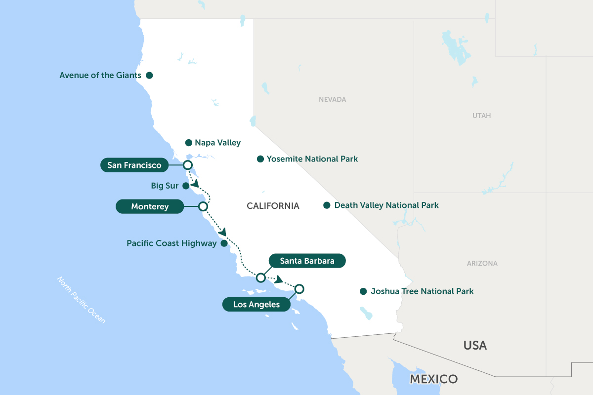
The sheer scale of California is often underestimated by first-time visitors. Stretching over 800 miles from north to south and averaging around 250 miles east to west, it encompasses a wide array of climates and topographies. This vastness means that travel within the state is less about quick hops and more about substantial road trips or strategic flights.
North to South: The Golden State’s Spanning Reach
Consider the journey from San Diego in the south to Eureka near the northern border, a distance exceeding 800 miles. This epic drive alone could take upwards of 12-14 hours of continuous driving, not accounting for stops, traffic, or overnight stays. Major population centers like Los Angeles and San Francisco are approximately 380 miles apart, a journey that typically requires 6-8 hours by car, depending heavily on traffic conditions, especially around metropolitan areas.
The state is broadly divided into distinct regions:
- Southern California: Home to Los Angeles, San Diego, and Orange County, characterized by beaches, deserts, and theme parks.
- Central California: Encompassing the Central Coast (Big Sur, Santa Barbara) and the vast Central Valley (agricultural heartland, cities like Fresno and Sacramento).
- Northern California: Featuring San Francisco, Wine Country (Napa Valley, Sonoma), Lake Tahoe, and redwood forests.
Each region offers distinct experiences, and traversing between them often involves significant travel time.
Coast to Desert: Diverse Landscapes and Distances
Beyond the north-south axis, the east-west distances also present unique travel considerations. The journey from the coastal plains of Los Angeles to the extreme desert environment of Death Valley National Park is about 270 miles, taking approximately 4.5-5 hours. Similarly, moving from the shores of San Francisco to the Sierra Nevada mountains, which host treasures like Yosemite National Park, is roughly 160-200 miles, translating to a 3.5-5 hour drive depending on the specific entrance and mountain road conditions. These diverse terrains mean that not only distance but also road types and elevation changes impact travel duration.
Key Travel Corridors and Estimated Times
Understanding the major arteries of California travel is crucial for efficient itinerary planning. These routes connect the state’s primary hubs and attractions.
Major Interstate Routes
- Interstate 5 (I-5): The main north-south freeway, running the entire length of the state, primarily through the Central Valley. It’s the fastest route for long-distance travel between Southern California and Northern California but is less scenic than coastal alternatives.
- Los Angeles to Sacramento: ~380 miles, 5.5-7 hours
- Sacramento to Redding: ~160 miles, 2.5-3 hours
- U.S. Route 101 (US-101): A more scenic, though often slower, alternative to I-5 along the coast. It connects Los Angeles with San Francisco and continues north through the redwood forests.
- Los Angeles to San Francisco via US-101: ~400 miles, 7-9 hours
- State Route 99 (CA-99): Runs parallel to I-5 through the Central Valley, connecting cities like Bakersfield, Fresno, and Sacramento.
- California State Route 1 (Highway 1): The legendary coastal highway, famous for its breathtaking views, particularly along Big Sur. While stunning, it is not a route for speed; sections can be winding, narrow, and subject to closures.
- Carmel-by-the-Sea to San Simeon (through Big Sur): ~90 miles, 2.5-4 hours (without significant stops)
Popular City-to-City Journeys
Understanding common travel segments helps in building realistic itineraries:
- Los Angeles to San Francisco: Approximately 380 miles, typically 6-8 hours by car via I-5, or 7-9 hours via US-101. Flying takes about 1.5 hours of flight time, but add airport commute and security for a total of 4-5 hours door-to-door.
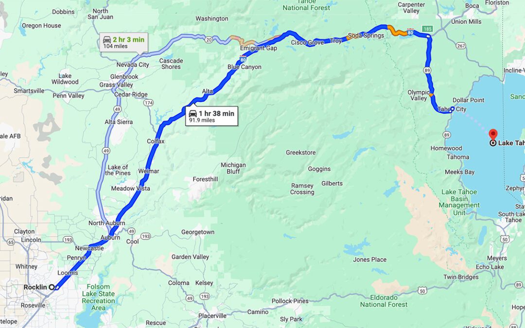
- San Francisco to Lake Tahoe: Roughly 180-200 miles, 3.5-4.5 hours drive. Winter conditions with snow can extend this significantly.
- San Diego to Palm Springs: Around 130 miles, 2-2.5 hours drive. A popular desert escape.
- Los Angeles to Santa Barbara: Approximately 95 miles, 1.5-2 hours drive.
- San Francisco to Napa Valley / Sonoma: About 50-60 miles, 1-1.5 hours drive, depending on specific destination and traffic through the Golden Gate Bridge corridor.
Navigating California’s Diverse Terrain
California’s topography is a major factor in travel times. Mountains, deserts, and urban sprawl each present unique considerations.
Mountain Passes and Scenic Byways
Driving through mountain ranges, such as the Sierra Nevada, introduces winding roads, elevation changes, and often slower speeds. Routes into Yosemite National Park, for instance, involve mountain passes that can be closed seasonally due to snow. Highway 395, running along the eastern Sierra Nevada, offers stunning views but requires careful planning for services and potential weather impacts, especially during winter. The iconic Big Sur section of Highway 1 is celebrated for its beauty but is known for its twisting roads and occasional closures due to mudslides or rockfalls. These scenic routes are destinations in themselves, not merely transit paths, and should be factored into daily travel distances with ample time.
Traffic Considerations in Urban Centers
While inter-city distances are significant, intra-city travel and navigating major metropolitan areas like Los Angeles and the San Francisco Bay Area can be equally time-consuming due to heavy traffic. Peak commute hours (typically 6:30 AM – 9:30 AM and 3:30 PM – 7:00 PM on weekdays) can double or even triple expected travel times within these regions.
- In Los Angeles, driving from Santa Monica to Hollywood, a distance of about 10-15 miles, can take anywhere from 30 minutes to over an hour during peak times.
- Crossing the San Francisco-Oakland Bay Bridge or the Golden Gate Bridge during rush hour can add significant delays to journeys within the Bay Area.
Travelers should always check real-time traffic updates using navigation apps when planning movement within or through these urban areas.
Optimizing Your California Itinerary
Effective planning is paramount to enjoying a California adventure, especially when considering distances.
Choosing Your Mode of Transport
- Driving: The most popular way to explore California due to the extensive road network and the flexibility it offers. Rental cars are readily available, but factor in fuel costs, parking fees, and potential tolls.
- Flying: For covering vast distances quickly (e.g., San Diego to San Francisco), flying between regional airports can save significant time. However, it sacrifices the scenic experience of a road trip and still involves airport transit. Major airports include LAX, SFO, and SAN.
- Trains & Buses: Amtrak offers several scenic routes, particularly along the coast (Pacific Surfliner, Coast Starlight), providing a relaxing alternative to driving. Bus services like Greyhound connect most major cities. While generally slower, these options can be more economical and allow travelers to avoid driving stress.
Strategic Stopovers and Multi-Day Trips
Instead of attempting to cover vast distances in a single grueling day, embrace the concept of strategic stopovers. Breaking a 6-8 hour drive into two 3-4 hour segments with an overnight stay allows for exploration of smaller towns or natural attractions along the way. For example, on a drive between Los Angeles and San Francisco via US-101, consider an overnight in San Luis Obispo or Monterey to enjoy the Central Coast. This transforms travel time into an integral part of the travel experience, enriching your understanding of California’s diverse offerings.

Seasonal Impacts on Travel Times
Weather and seasonal events can significantly influence how far away things feel in California.
- Winter: Snowfall can close mountain passes (Tioga Pass in Yosemite is a prime example) and make driving challenging in the Sierra Nevada and other higher elevations, requiring chains or 4×4 vehicles. Coastal routes can experience heavy rains and fog.
- Summer: Popular destinations see peak tourist numbers, leading to increased traffic and longer lines at attractions. Desert temperatures can be extreme, influencing driving conditions and vehicle performance.
- Wildfires: Unfortunately, wildfires are a seasonal concern, particularly in late summer and fall. These can lead to road closures, detours, and poor air quality, impacting travel plans. Always check local conditions and official alerts before and during your trip.
In conclusion, “how far away” in California is not just a simple mileage calculation. It’s a complex interplay of geographical scale, diverse terrain, traffic patterns, and seasonal variations. Thoughtful planning, flexibility, and a willingness to embrace the journey itself will ensure a memorable and efficient exploration of this magnificent state.
LifeOutOfTheBox is a participant in the Amazon Services LLC Associates Program, an affiliate advertising program designed to provide a means for sites to earn advertising fees by advertising and linking to Amazon.com. Amazon, the Amazon logo, AmazonSupply, and the AmazonSupply logo are trademarks of Amazon.com, Inc. or its affiliates. As an Amazon Associate we earn affiliate commissions from qualifying purchases.