
Traveling between the contiguous states of Oregon and California is a common journey for both leisure and business. While they share a lengthy border, the actual “distance” is not a single, fixed number but rather a dynamic measure influenced by specific starting and ending points, chosen routes, and modes of transportation. Understanding these variables is key to planning an efficient and enjoyable trip, whether you’re embarking on a road adventure, hopping on a train, or taking to the skies.
Understanding the Geographical Scope
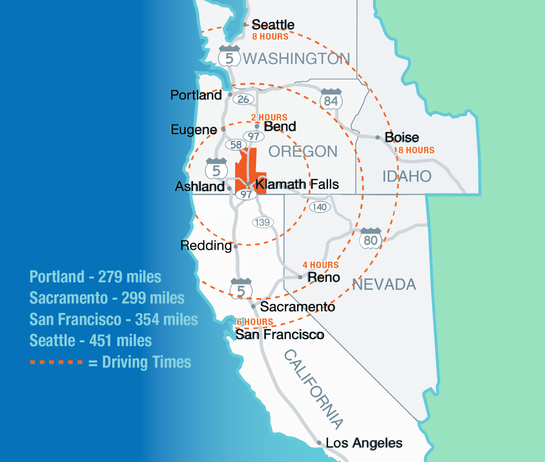
Oregon lies directly north of California, sharing an approximately 300-mile long border. This proximity means that while some trips might be relatively short – crossing the border from Southern Oregon into Northern California – others can span nearly the entire length of both states. For instance, a journey from Portland, Oregon’s largest city, to San Francisco, a major California hub, is significantly different in scope than traveling from Ashland, a southern Oregon town, to Redding in northern California. The average drive from the northern reaches of Oregon to the southern tip of California could easily exceed 1,000 miles, requiring careful planning and often an overnight stop.
Key Travel Routes and Distances
The vast majority of travel between Oregon and California occurs via road, offering travelers flexibility and the opportunity to experience the diverse landscapes of the Pacific West Coast.
The I-5 Corridor: The Main Artery
Interstate 5 is the undisputed primary highway connecting the two states. Stretching from Mexico to Canada, it’s the fastest and most direct route, cutting through central valleys and urban centers.
- Portland, Oregon to San Francisco, California: This popular route covers approximately 630-650 miles and typically takes 10-11 hours of non-stop driving. However, factoring in fuel stops, meals, and short breaks, travelers should budget 12-14 hours.
- Portland, Oregon to Los Angeles, California: A significantly longer journey, this trip spans roughly 960-980 miles and requires 15-16 hours of driving without major stops. Most travelers prefer to break this journey into a two-day trip, perhaps with an overnight stay in Sacramento or a smaller town in northern California.
- Ashland, Oregon to Sacramento, California: For those closer to the border, this route is about 320 miles and takes approximately 5-6 hours.
- Ashland, Oregon to Redding, California: One of the shortest cross-border drives, it’s roughly 100 miles and takes about 1.5-2 hours.
Scenic Alternatives: US-101 and Coastal Drives
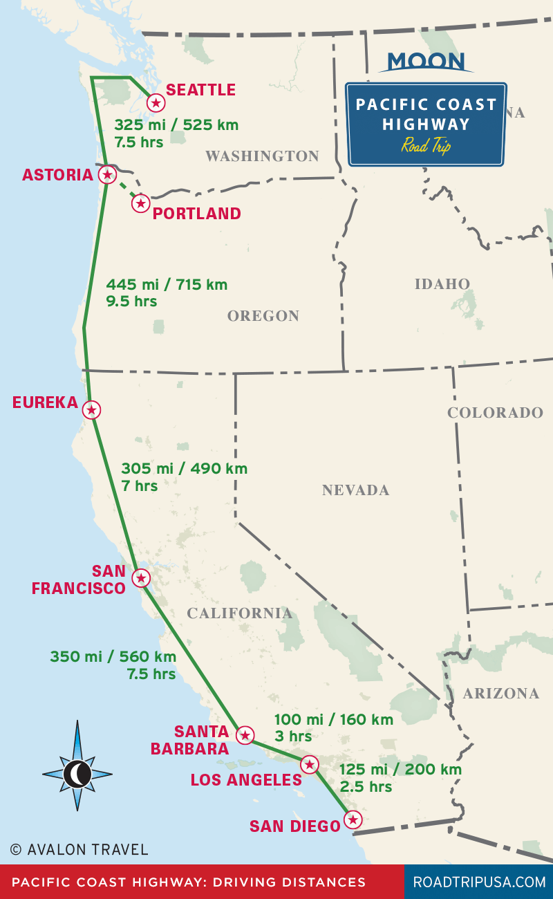
For travelers with more time and a desire for breathtaking scenery, US-101, often referred to as the Pacific Coast Highway in parts of California, offers a stunning alternative. This route hugs the coastline for much of its length, winding through charming coastal towns, dense forests, and offering spectacular ocean views.
- Route Characteristics: While immensely picturesque, US-101 is significantly slower due to its winding nature, lower speed limits, and frequent stops in communities. A journey that takes 10 hours on I-5 could easily take 14-16 hours or more on the coast.
- Key Highlights: Traveling this route allows access to the rugged beauty of the Oregon Coast, the ancient giant trees of Redwood National Park in northern California, and iconic landmarks like the Golden Gate Bridge in San Francisco.
- Example: A trip from Astoria, Oregon to San Francisco, California via the coastal route can be around 700 miles, requiring a minimum of 14-16 hours of pure driving time and often necessitating multiple overnight stays to truly enjoy the experience.
Eastern Routes and Mountain Passes
Less common but equally valid are routes that traverse the eastern parts of both states. Highways like US-395 in California or various state routes in eastern Oregon can be utilized, particularly if your destination or origin is east of the Cascade Range. These routes offer different scenery, often featuring high deserts, volcanic landscapes, and mountain ranges. It’s crucial to note that many mountain passes, including the infamous Siskiyou Pass on I-5 near the border, can experience challenging weather conditions, especially during winter months, which can significantly impact travel times and safety.
Factors Influencing Travel Time and Experience
Beyond the raw distance, several critical factors shape the actual time and enjoyment of your journey between Oregon and California.
Traffic and Congestion
Urban centers along the I-5 corridor, such as Portland, Sacramento, the Bay Area (particularly around Oakland and San Jose on routes leading into San Francisco), and Los Angeles, are notorious for heavy traffic. Traveling through these areas during peak rush hour (typically 7-9 AM and 4-6 PM on weekdays) can add hours to your journey. Planning to pass through these cities during off-peak times, or even late at night, can save considerable time and frustration.
Weather Conditions

The Pacific Northwest and California experience diverse climates, and weather can play a significant role in travel logistics:
- Winter: Snow and ice are common in the mountainous regions, particularly on Siskiyou Pass on I-5 and other high-elevation routes. Chain requirements for tires are often enforced, and roads can close. Always check weather forecasts and road conditions before setting out in winter.
- Summer: While generally pleasant, summer brings its own challenges. Intense heat waves, especially in inland California valleys, can affect vehicle performance and traveler comfort. Wildfires are also a growing concern, potentially causing road closures, detours, and smoky air that can impact visibility and health.
Stops and Detours
A cross-state road trip offers numerous opportunities for exploration. Incorporating stops for rest, meals, and sightseeing will naturally extend travel time but enrich the experience. Popular attractions along the way include:
- Crater Lake National Park in Southern Oregon
- Oregon Caves National Monument
- Lassen Volcanic National Park in Northern California
- The numerous state parks and beaches along the US-101 route.
Factor these into your itinerary and be realistic about how much you can comfortably cover in a day.
Vehicle Type and Fuel Efficiency
The type of vehicle you drive impacts both the cost and the number of stops you’ll need. Fuel efficiency varies greatly, and planning fuel stops in advance, especially in less populated areas, can prevent unnecessary delays. For longer journeys, consider checking your vehicle’s tires, fluids, and general condition before departure.
Alternative Modes of Transportation
While driving is popular, other options exist for traveling between Oregon and California, each with its own advantages and considerations.
Flying
For speed and convenience over long distances, flying is unmatched.
- Major Airports: Key hubs include Portland International Airport (PDX) in Oregon, and San Francisco International Airport (SFO), Los Angeles International Airport (LAX), and Sacramento International Airport (SMF) in California.
- Travel Times: Direct flights between Portland and San Francisco typically take around 1.5 hours, while flights to Los Angeles are approximately 2-2.5 hours. However, total travel time including airport check-in, security, and transfers can easily add 3-5 hours to the flight duration.
- Cost: Airfare can vary widely based on booking in advance, time of year, and airline. It’s often more expensive than driving for solo travelers but can be cost-effective for groups or those needing to save time.
Train Travel (Amtrak)
Amtrak offers a scenic and relaxing way to travel between the states. The Coast Starlight route is particularly renowned, offering stunning views of the Pacific coastline, mountain ranges, and forests.
- Route: The Coast Starlight connects major cities like Seattle, Portland, Salem, Eugene in Oregon, to Sacramento, the San Francisco Bay Area (via bus connection from Emeryville), and Los Angeles in California.
- Travel Times: Train journeys are considerably longer than driving or flying. For example, a trip from Portland to San Francisco Bay Area can take 10-12 hours, and to Los Angeles can exceed 20 hours.
- Experience: While slow, train travel offers comfort, spacious seating, dining cars, and the ability to relax and enjoy the journey without the stress of driving.
Bus Services
Several bus companies, including Greyhound, provide intercity services between Oregon and California.
- Economy: Bus travel is typically the most economical option.
- Travel Times: Similar to train travel, bus journeys are longer due to multiple stops and potential transfers. A trip from Portland to Los Angeles could take 20-24 hours, often involving transfers.
- Convenience: Bus stations are often centrally located in cities, making them accessible. However, comfort levels can vary.
Planning Your Oregon-California Journey
To effectively answer “How far is Oregon from California?” for your specific needs, consider these planning steps:
- Define Your Exact Points: Pinpoint your precise starting and ending locations within each state. This is the single most important factor.
- Choose Your Priority: Decide whether speed, scenic beauty, budget, or comfort is your primary concern. This will guide your choice of route and mode of transport.
- Utilize Mapping Tools: Online mapping applications (like Google Maps, Apple Maps, or Waze) are invaluable for calculating distances, estimating travel times, and providing real-time traffic updates.
- Check Conditions: Always verify weather forecasts and road conditions (via state DOT websites or apps) immediately before and during your trip, especially for road travel.
- Book in Advance: For flights and train tickets, booking ahead usually secures better prices and ensures availability.
- Prepare for Road Trips: If driving, ensure your vehicle is in good condition, pack an emergency kit, snacks, water, and entertainment for passengers. Plan for regular breaks to combat driver fatigue.
Ultimately, the distance between Oregon and California is more than just miles on a map; it’s a measure of the journey itself, an opportunity to experience the diverse landscapes and vibrant cultures of the Pacific West Coast. By understanding the various routes and factors involved, travelers can plan a trip that perfectly aligns with their expectations and delivers a memorable adventure.
LifeOutOfTheBox is a participant in the Amazon Services LLC Associates Program, an affiliate advertising program designed to provide a means for sites to earn advertising fees by advertising and linking to Amazon.com. Amazon, the Amazon logo, AmazonSupply, and the AmazonSupply logo are trademarks of Amazon.com, Inc. or its affiliates. As an Amazon Associate we earn affiliate commissions from qualifying purchases.