
When planning a visit to Chicago, one of the most common questions travelers have revolves around public transportation: Does Chicago have a subway system? The answer is both yes and no, and understanding this nuance is key to navigating the Windy City like a local. While Chicago does indeed have an extensive rapid transit system with underground sections, it is most famously known as the ‘L’, short for ‘elevated railway’. This iconic network, operated by the Chicago Transit Authority (CTA), is a vital artery of urban travel, offering an authentic and efficient way to explore one of America’s greatest cities.

Understanding Chicago’s Urban Transit Landscape: The ‘L’ System
The Chicago ‘L’ is a comprehensive rapid transit system that serves the city and some surrounding suburbs. While portions of its tracks run underground, particularly through the downtown Loop area and along certain extensions, a significant and visually striking portion operates on elevated tracks. This dual nature is what often leads to the ‘subway’ question. The ‘L’ is more than just a means of getting from point A to point B; it’s an experience in itself, offering unique perspectives of Chicago’s stunning architecture and vibrant neighborhoods as it rumbles along its overhead tracks.
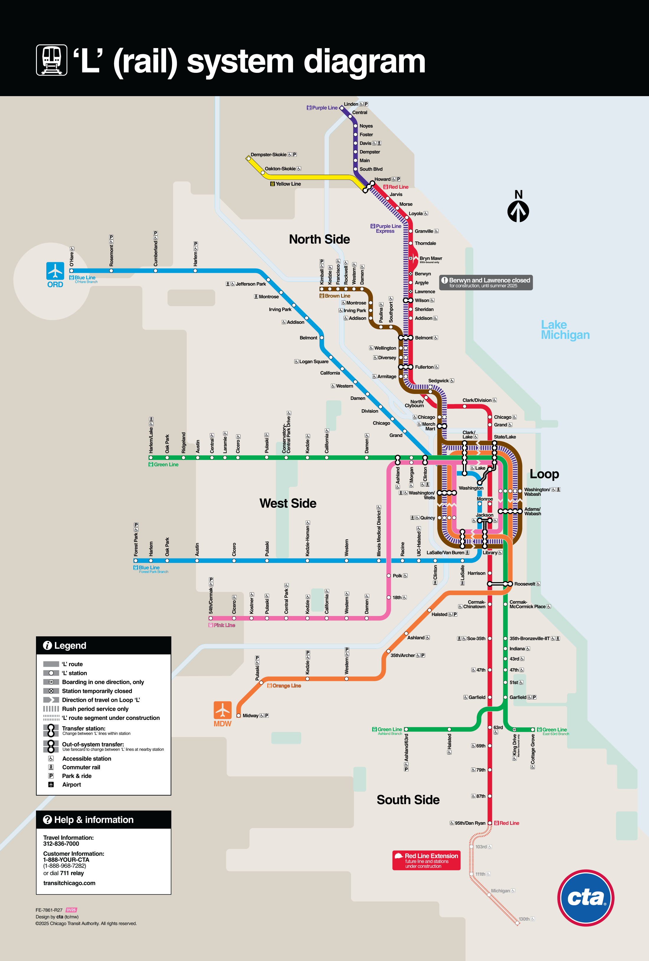
The system comprises eight color-coded lines, each serving different parts of the metropolitan area and operating with varying schedules. Crucially for travelers, two lines provide direct connections to Chicago’s major airports: the Blue Line runs to O’Hare International Airport, and the Orange Line connects to Midway International Airport. This makes the ‘L’ an incredibly convenient and cost-effective option for arriving and departing visitors, bypassing expensive taxi fares and potential traffic delays.
The ‘L’ trains are a quintessential part of the Chicago experience, with their distinctive sound and visual presence adding to the city’s urban soundtrack. Navigating the city via the ‘L’ not only offers unparalleled convenience but also immerses travelers directly into the rhythm of daily life for residents, providing a deeper connection to the destination.
Navigating the City’s Core: Major Lines and Key Destinations
For any traveler exploring Chicago, understanding how the ‘L’ lines connect to the city’s famous attractions is paramount. The system is designed to provide access to virtually every major landmark and cultural institution, making it an indispensable tool for sightseeing.
The Loop: The Heart of the ‘L’
The Loop is the central business district of Chicago and the true heart of the ‘L’ system. Several lines – the Brown Line, Green Line, Orange Line, Pink Line, and Purple Line Express – share tracks in the famous elevated loop structure, encircling the district. This unique configuration allows for easy transfers between lines and provides unparalleled access to downtown attractions. From the Loop stations, visitors are just steps away from iconic architecture, the bustling State Street shopping corridor, and a plethora of dining options.
Connecting to Iconic Attractions
- Millennium Park & Art Institute of Chicago: The Green Line, Pink Line, Orange Line, Brown Line, and Purple Line Express all have stops within a short walk of these cultural gems. Disembark at the Washington/Wabash or Adams/Wabash stations.
- Museum Campus: To reach the Shedd Aquarium, Field Museum, and Adler Planetarium, travelers can take the Red Line or Orange Line to the Roosevelt station and then transfer to a bus or enjoy a pleasant walk through Grant Park.
- Navy Pier: While no ‘L’ line goes directly to Navy Pier, several lines – Red Line, Blue Line, Green Line, Brown Line, Orange Line, Pink Line, Purple Line – have stops within walking distance or a short bus ride. The Grand/State station on the Red Line is a popular starting point.
- Magnificent Mile & Water Tower Place: The Red Line is your best bet for accessing this premier shopping and dining district. Stations like Chicago and Grand provide direct access to Michigan Avenue.
- Willis Tower: The Brown Line, Orange Line, Pink Line, Purple Line Express (Quincy/Wells station), and the Blue Line and Red Line (Jackson station) are all within easy walking distance.
- Lincoln Park Zoo: Take the Brown Line or Purple Line to the Armitage or Fullerton stations, then enjoy a scenic walk through the neighborhood to the zoo.
The ‘L’ extends far beyond the downtown area, allowing travelers to venture into vibrant neighborhoods like Wicker Park, Logan Square, and Hyde Park, each offering unique cultural experiences, dining, and nightlife.
The Historical Tapestry of Chicago’s Elevated Rails
The history of Chicago’s rapid transit is as rich and complex as the city itself. The first elevated line, the South Side Elevated Railroad, began operation in 1892, preceding the city’s much later foray into truly underground ‘subway’ sections. The purpose of these elevated lines was to provide a faster alternative to street-level streetcars, bypassing the traffic congestion of a rapidly growing urban center.
Over the decades, different private companies built and operated various elevated lines. It wasn’t until 1947 that the Chicago Transit Authority (CTA) was formed, consolidating these disparate lines into a single, unified public system. The ‘L’ continued to expand, with new lines and extensions, some of which incorporated subway tunnels. For example, the Red Line subway under State Street and the Blue Line subway under Dearborn Street were significant additions in the 1940s and 1950s, finally giving Chicago its bona fide underground segments.
This blend of elevated and subway infrastructure is a testament to Chicago’s innovative urban planning and its continuous adaptation to the needs of its residents and visitors. The ‘L’ is not merely a transportation network; it’s a living monument to the city’s industrial heritage and an integral part of its identity.
Practicalities for the Modern Traveler: Fares, Maps, and Etiquette
Utilizing the ‘L’ is straightforward once you understand a few key practicalities.
Fares and Passes
The easiest way to pay for ‘L’ rides is with a Ventra Card. These reloadable cards can be purchased and loaded with transit value or unlimited ride passes at ‘L’ stations, online, or at various retail locations. A single fare is affordable, and multi-day passes (1-day, 3-day, 7-day) offer excellent value for tourists planning extensive use of public transit. Contactless payment directly with a credit/debit card or mobile wallet is also accepted at all turnstiles. Remember to tap in at the beginning of your journey; no need to tap out.
Navigating with Maps and Apps
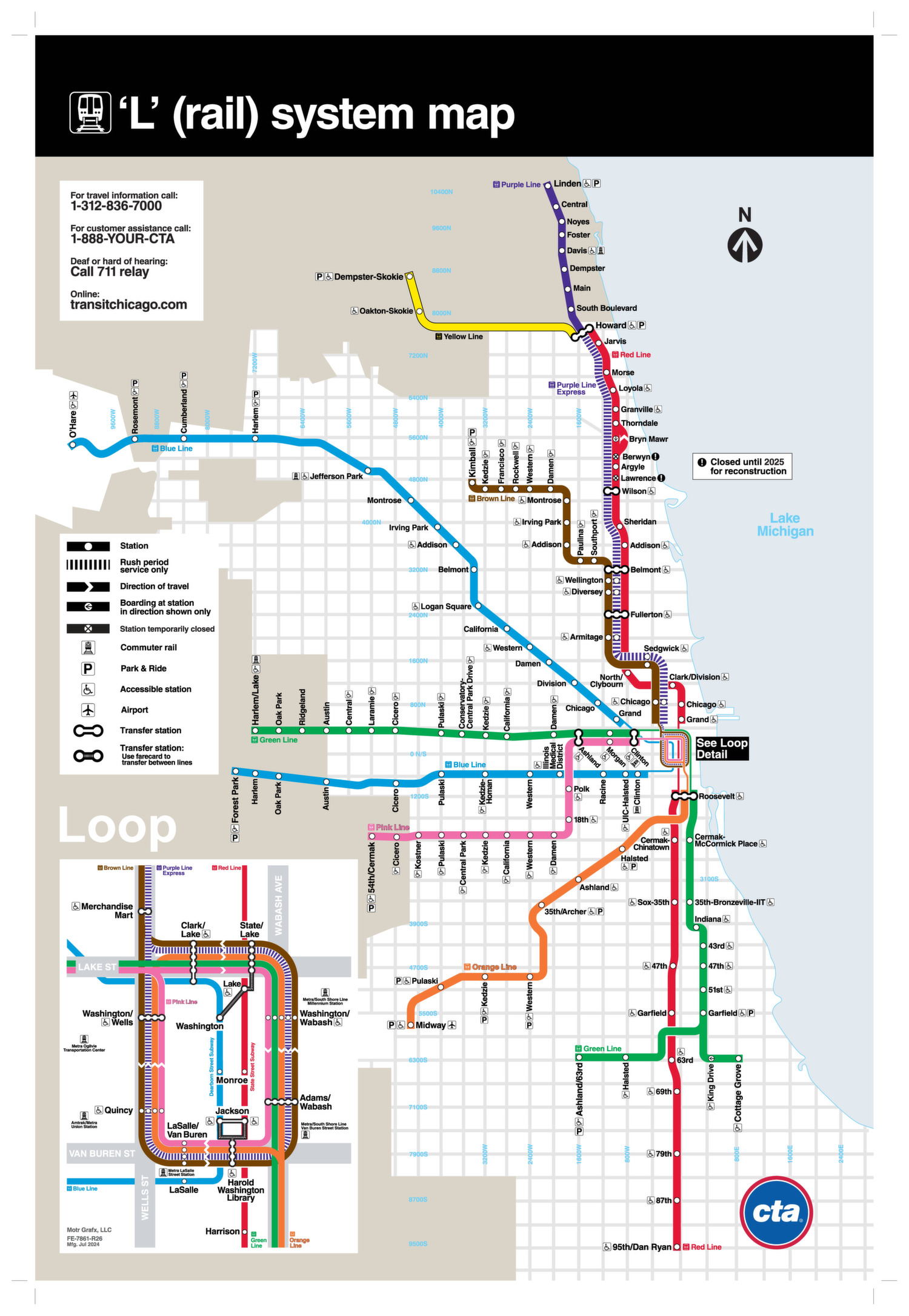
CTA maps are readily available at stations and online, clearly illustrating all ‘L’ lines and connections. For real-time tracking, schedules, and service alerts, official CTA apps and popular transit apps like Google Maps or Citymapper are invaluable tools. These apps can help you plan your journey, identify the fastest route, and anticipate arrival times.
Etiquette and Safety
Like any major urban transit system, a few common courtesies and safety tips enhance the experience:
- Stand to the right on escalators: Allow those in a hurry to walk on the left.
- Offer seats: Be mindful of elderly, pregnant, or disabled passengers who may need a seat.
- Keep clear of doors: Allow passengers to exit before attempting to board.
- Hold onto belongings: Keep bags close and be aware of your surroundings, especially during peak hours.
- Utilize operator announcements: Pay attention to important information regarding delays or station closures.
The CTA takes safety seriously, with visible security presence and surveillance systems. Traveling on the ‘L’ is generally safe, especially during daylight hours and in well-trafficked areas.
Beyond Transport: The ‘L’ as a Quintessential Chicago Experience
Riding the ‘L’ offers more than just convenient transit; it provides a unique window into the soul of Chicago. The elevated sections, in particular, serve as moving observation decks. As trains wind through the urban canyon of the Loop, passengers are treated to breathtaking views of architectural marvels, often at eye-level with the ornate details of historic skyscrapers. The glimpses into back alleys, residential streets, and diverse neighborhoods offer an unfiltered perspective of the city that simply cannot be experienced from street level or from a car.
The rhythmic rumble of the trains, the snippets of conversations in different languages, and the diverse mix of daily commuters, students, and fellow travelers create a vibrant tapestry of urban life. For a destination focused on experiences, the ‘L’ is an attraction in itself – a dynamic, sensory journey that reinforces Chicago’s reputation as a city that moves. So, while Chicago might not call its entire system a ‘subway,’ its ‘L’ system, with its combination of elevated and underground tracks, offers a truly authentic and unforgettable way to explore this magnificent city. It’s an integral part of the travel adventure, connecting visitors not just to places, but to the very essence of Chicago.
LifeOutOfTheBox is a participant in the Amazon Services LLC Associates Program, an affiliate advertising program designed to provide a means for sites to earn advertising fees by advertising and linking to Amazon.com. Amazon, the Amazon logo, AmazonSupply, and the AmazonSupply logo are trademarks of Amazon.com, Inc. or its affiliates. As an Amazon Associate we earn affiliate commissions from qualifying purchases.