
Nestled along the shimmering coastline of the Gulf of Mexico, the city of Indian Rocks Beach serves as a tranquil escape within the vibrant landscape of Florida. For travelers seeking a destination that balances accessibility with a “forgotten Florida” charm, understanding exactly where this coastal gem is located is the first step in planning an unforgettable journey. Situated on a barrier island in Pinellas County, this town is part of a delicate chain of islands that protect the mainland from the open sea, offering a unique geographical experience that distinguishes it from the more commercialized hubs of the United States coastline.
The Geographical Orientation of Indian Rocks Beach
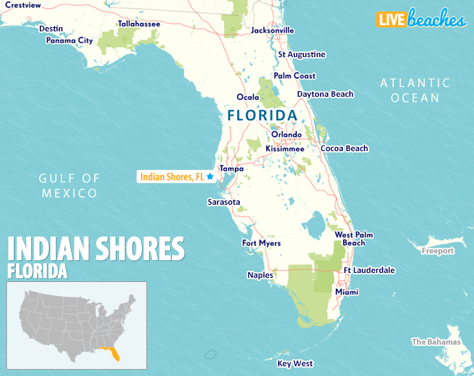
To pinpoint the location of Indian Rocks Beach, one must look to the central-western coast of the Florida peninsula. It is positioned roughly midway between the northern and southern tips of Pinellas County, a peninsula itself that is surrounded by Tampa Bay to the east and the Gulf of Mexico to the west. This strategic location places it within the Tampa metropolitan area, providing travelers with the luxury of secluded beach life while remaining within a short drive of major urban centers.
Pinellas County and the Suncoast
Indian Rocks Beach is a vital part of what locals and travel enthusiasts call the Suncoast. This region is famous for its white, powdery sand and emerald waters. Geographically, the town is located south of Clearwater and north of St. Petersburg. It occupies a thin strip of land, often less than a mile wide, where the rhythm of life is dictated by the tides. To the east of the island lies the Intracoastal Waterway, a navigable inland water route that separates the barrier islands from the mainland cities of Largo and Seminole.
The Barrier Island Anatomy
The physical “where” of Indian Rocks Beach is defined by its barrier island structure. Unlike mainland coastal towns, the city is entirely surrounded by water. To the west, the infinite horizon of the Gulf of Mexico provides a backdrop for world-class sunsets. To the east, the Intracoastal Waterway offers a calm harbor for boating and fishing. The island is connected to the mainland by the Belleair Causeway to the north and the Walsingham Bridge (also known as the Indian Rocks Causeway) at its center. This layout makes the town an “island retreat” in the truest sense, reachable only by crossing these scenic spans of water.
Strategic Travel Routes: How to Reach the Island
When travelers ask “Where is Indian Rocks Beach?”, they are often looking for the logistical “how-to” of arrival. Its location is exceptionally convenient for domestic and international travelers alike, thanks to its proximity to several major transportation hubs on Florida’s West Coast.
Major Airport Hubs
The primary gateway for visitors is Tampa International Airport, located approximately 25 miles to the east. This award-winning airport handles flights from across the globe, making Indian Rocks Beach a straightforward destination for those flying in. From the airport, the drive typically takes 40 to 60 minutes, depending on traffic, crossing the Howard Frankland Bridge or the Courtney Campbell Causeway to enter Pinellas County.
An even closer option is the St. Pete-Clearwater International Airport, situated about 12 miles from the beach. This airport is a hub for budget-friendly carriers and offers a more intimate, less crowded arrival experience. For those traveling from within Florida, the town is easily accessible from Orlando, which is roughly a two-hour drive to the northeast, or Sarasota, which is about an hour to the south.
Driving Directions from Regional Cities
If you are driving from Central Florida, you will likely take Interstate 4 West toward Tampa, then transition to State Road 60 or Interstate 275. For those coming from the south, such as Miami or Fort Myers, the Sunshine Skyway Bridge provides a dramatic entrance into the region, offering panoramic views of Tampa Bay before guiding you toward the coastal turn-offs for the barrier islands.
Navigating the Local Landscape
Once you have arrived on the island, the geography becomes incredibly linear. Indian Rocks Beach is approximately 2.7 miles long, making it a compact and walkable destination. Navigating the town is simple once you understand its primary thoroughfares and layout.
The Significance of Gulf Boulevard
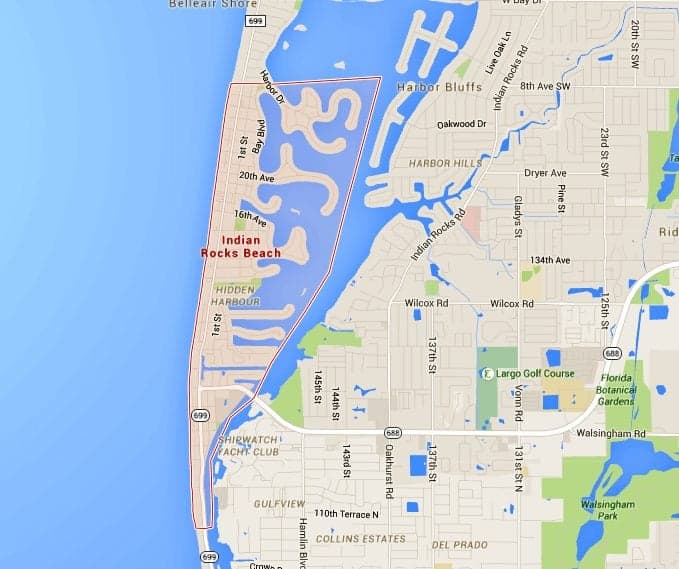
The backbone of the island is Gulf Boulevard. This famous coastal road runs north to south along the entire length of the Pinellas County barrier islands. In Indian Rocks Beach, Gulf Boulevard serves as the main artery for travel, connecting the various beach access points, local businesses, and residential neighborhoods. Travelers can follow this road north into Belleair Beach or south into Indian Shores.
Bridges and Access Points
Understanding the bridge system is essential for any traveler. The Walsingham Bridge connects the heart of the city to Largo on the mainland. This is often the most used entrance for visitors who have been exploring mainland attractions or shopping centers. At the northern end of the city, the Belleair Causeway provides access to Belleair Bluffs. These bridges are not just functional; they provide some of the best vantage points for photographing the Intracoastal Waterway.
Surrounding Destinations and Coastal Neighbors
One of the greatest travel advantages of Indian Rocks Beach is its proximity to other iconic Florida landmarks. While the city itself offers a quiet, residential feel, it is surrounded by high-energy tourist destinations.
The North: Belleair and Clearwater
Just a few minutes to the north lies Sand Key Park, a sprawling 95-acre park that offers a more rugged and natural beach experience. Continuing north across the Sand Key Bridge brings you directly into Clearwater Beach. Known for its bustling promenade, Pier 60, and the Clearwater Marine Aquarium, Clearwater is the perfect contrast to the low-key atmosphere of Indian Rocks Beach. Travelers often stay in the quieter Indian Rocks Beach while making day trips to Clearwater for its more intense tourist activities.
The South: Indian Shores and Beyond
To the south, the island chain continues with Indian Shores, Redington Shores, and Madeira Beach. A short 15-minute drive south on Gulf Boulevard leads to John’s Pass Village and Boardwalk, a historic fishing village that has evolved into a premier destination for shopping, dining, and dolphin-watching tours. Further south still, travelers will find Treasure Island and the world-renowned St. Pete Beach. This proximity allows visitors to experience a wide variety of Gulf Coast cultures within a very small geographic radius.
Planning Your Arrival: Timing and Logistics
Knowing where Indian Rocks Beach is also involves understanding the best times to arrive and how to manage local travel logistics. As a coastal destination in Florida, the experience varies significantly with the seasons.
Weather and Seasonal Travel
The city is located in a subtropical climate zone. This means that from late autumn through spring, the weather is mild and dry, making it a peak travel period for those fleeing colder climates in the northern United States or Canada. During the summer months, the location is subject to the afternoon thunderstorms typical of the Gulf of Mexico region. Travelers should be aware that the “where” also dictates the “when”; the beauty of the Gulf Coast is best enjoyed during the “shoulder seasons” of March to May and October to November, when the humidity is low and the water temperature remains pleasant.
Getting Around Local Traffic
While the island is small, traffic on Gulf Boulevard can become congested during peak tourist seasons or holiday weekends. For a more relaxed travel experience, many visitors utilize the Suncoast Beach Trolley. This convenient transit service runs from Park Street Terminal in Clearwater all the way down to St. Pete Beach, with numerous stops throughout Indian Rocks Beach. Using the trolley allows travelers to leave their vehicles behind and enjoy the scenic views of the Gulf of Mexico without the stress of navigating local roads.

Exploring the Natural Geography
The location of Indian Rocks Beach is not just about roads and bridges; it is also defined by its unique natural ecosystems. The town is home to the Indian Rocks Beach Nature Preserve, which offers a boardwalk through lush mangroves, leading toward the Intracoastal Waterway. This area provides a glimpse into the original landscape of the Florida coastline before modern development.
Additionally, the city’s location near the Pinellas Trail on the mainland offers travelers a chance to explore the region by bicycle. The trail stretches from St. Petersburg all the way north to Tarpon Springs, passing through Dunedin and Palm Harbor. While the trail does not run directly through the island, it is easily accessible via the Belleair Causeway, making Indian Rocks Beach an excellent home base for active travelers looking to see more of Pinellas County.
Whether you are arriving for a weekend of relaxation or a month of exploration, the location of Indian Rocks Beach provides the perfect starting point. It is a place where the geography of the Gulf Coast creates a natural sanctuary, perfectly positioned between the convenience of the mainland and the boundless beauty of the sea. By understanding its place on the map and the routes that lead there, you can ensure your trip to this part of Florida is seamless and rewarding.
LifeOutOfTheBox is a participant in the Amazon Services LLC Associates Program, an affiliate advertising program designed to provide a means for sites to earn advertising fees by advertising and linking to Amazon.com. Amazon, the Amazon logo, AmazonSupply, and the AmazonSupply logo are trademarks of Amazon.com, Inc. or its affiliates. As an Amazon Associate we earn affiliate commissions from qualifying purchases.