
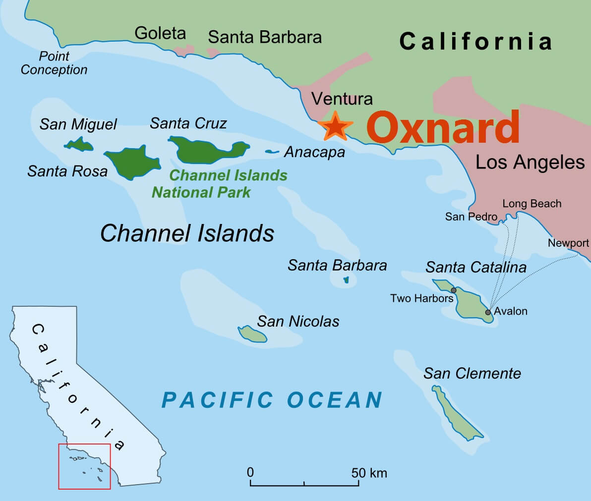
Understanding the geographical relationship between Oxnard and Los Angeles is a fundamental piece of information for anyone planning a trip, considering a day excursion, or even contemplating a relocation within Southern California. This proximity, or indeed distance, dictates travel times, mode of transportation choices, and the overall feasibility of combining these two distinct Southern California locales into a single itinerary. While both are undeniably part of the vast Southern California sprawl, they offer vastly different experiences, making the journey between them a significant consideration.
The distance between Oxnard and Los Angeles is not a static figure but rather a variable influenced by the specific starting and ending points within each expansive region and, critically, the chosen route and time of travel. The greater Los Angeles metropolitan area is a complex network of cities, each with its own distinct character and points of interest. Similarly, Oxnard, while a city in its own right, is part of the larger Ventura County and its proximity to surrounding communities also plays a role.

Navigating the Distance: Road Travel and Time Estimates
The most common method for traversing the distance between Oxnard and Los Angeles is by car. This offers the most flexibility, allowing travelers to set their own pace and stop at points of interest along the way. The primary routes typically involve utilizing the 101 Freeway (also known as the Ventura Freeway in this stretch).
Direct Driving Routes
From downtown Los Angeles to downtown Oxnard, the approximate driving distance is around 65 to 70 miles. However, this seemingly straightforward mileage can translate into a surprisingly variable travel time.
- Peak Traffic Conditions: Traveling during weekday rush hours (typically 6 AM to 10 AM and 3 PM to 7 PM) can significantly extend the journey. During these times, traffic congestion on the 101 Freeway can be substantial, pushing travel times upwards of 1.5 to 2.5 hours, and sometimes even longer. This is due to the sheer volume of commuters and the intricate weave of freeways and surface streets in the Los Angeles basin.
- Off-Peak Travel: Conversely, embarking on the drive during off-peak hours, such as late morning, early afternoon, or on weekends, can dramatically reduce travel time. In ideal conditions, with minimal traffic, the drive can be completed in as little as 1 hour to 1 hour and 15 minutes. This allows for a more relaxed and efficient journey, maximizing time spent at the destination.
- Alternative Routes and Considerations: While the 101 Freeway is the most direct, other routes might be considered depending on specific origin and destination points within the vastness of Los Angeles. For instance, heading north from parts of the San Fernando Valley might involve routes like the 405 Freeway initially before merging onto the 101. These alternative routes can also be subject to their own traffic patterns and may not always offer a time advantage.
The choice of destination within Oxnard also matters. Whether you’re heading to the Channel Islands Harbor, the historic downtown area, or a specific residential neighborhood, the final few miles can add to the overall travel time. Similarly, starting from a specific neighborhood in Los Angeles, such as Santa Monica or Pasadena, will impact the initial mileage and potential traffic encountered.
Public Transportation Options: An Alternative Perspective
For those who prefer not to drive or wish to avoid the stress of navigating Los Angeles traffic, public transportation offers viable alternatives for reaching Oxnard. While not as direct or as frequent as driving, these options can be economical and environmentally friendly.
Rail Services
The Metrolink commuter rail service provides a direct connection between Los Angeles and Oxnard.
- Ventura County Line: The Metrolink Ventura County Line operates from stations in downtown Los Angeles (e.g., Union Station) and terminates at the Oxnard Transportation Center. This is a convenient option for travelers who can access these stations easily.
- Travel Time and Frequency: The train journey typically takes approximately 2 hours to 2 hours and 30 minutes, depending on the number of stops. Metrolink operates primarily during weekday commute hours, with fewer trains running on weekends. It’s crucial to check the schedule in advance to ensure alignment with your travel plans.
- Advantages: Traveling by train allows passengers to relax, read, or work during the journey, avoiding the mental drain of driving in heavy traffic. It also provides a scenic view of the Southern California landscape as you move away from the urban core.
Bus Services
Several bus services operate between Los Angeles and Oxnard, though these often involve transfers and can be slower than rail.
- Local and Regional Bus Lines: Options like Amtrak Thruway Bus services, which often connect to Metrolink or Amtrak train stations, are available. Additionally, local transit agencies may offer regional bus routes, though these are generally the slowest option.
- Travel Time and Convenience: Bus journeys can range from 2.5 to 4 hours or more, depending on the route, number of stops, and traffic conditions. While generally more affordable than train tickets, the extended travel time might make them less appealing for shorter day trips.
It is always recommended to consult the official websites of Metrolink, Amtrak, and local transit authorities for the most up-to-date schedules, fares, and route information.
Factors Influencing Travel Time and Distance
Beyond the direct mileage and choice of transportation, several external factors can influence the perceived distance and actual travel time between Oxnard and Los Angeles.
Traffic Patterns
As previously mentioned, traffic is the single most significant variable. The sprawling nature of Los Angeles means that the “distance” can feel much greater during peak hours due to the sheer volume of vehicles and the complexity of the freeway system. Events, accidents, or road construction can also cause unpredictable delays, turning a short drive into a frustrating crawl. Real-time navigation apps are invaluable tools for monitoring traffic conditions and making informed decisions about departure times and routes.
Starting and Ending Points
The “distance” is not solely between the city centers of Los Angeles and Oxnard. If your starting point is, for example, the Los Angeles International Airport (LAX) and your destination is a hotel in the Channel Islands Harbor, the mileage will differ from a journey between downtown Los Angeles and Oxnard’s downtown core. Understanding your precise origin and destination is key to accurately estimating travel time.
Time of Day and Day of Week
Weekends often see different traffic patterns than weekdays. While commuter traffic subsides, leisure travel can increase congestion, particularly on routes leading to popular coastal destinations like those near Oxnard. Holiday weekends can be especially challenging. Planning your travel to coincide with periods of lower traffic is often the best strategy for a smooth journey.
Weather Conditions
While Southern California is generally known for its pleasant weather, extreme conditions can still impact travel. Heavy rain, fog, or strong winds can reduce visibility and slow down traffic, making driving more hazardous and extending travel times.
The Experience of Travel: Beyond the Mileage
The journey from Los Angeles to Oxnard is more than just covering a set number of miles; it’s an experience that transitions you from the bustling urban landscape of one of the world’s largest metropolises to the more laid-back, coastal charm of Ventura County.
Transitioning Landscapes
As you drive north on the 101 Freeway, you witness a gradual shift in scenery. The dense urban sprawl of Los Angeles gives way to more open spaces, rolling hills, and eventually, the distinctive agricultural fields that characterize parts of Ventura County. This visual transition can be a refreshing part of the travel experience, offering a glimpse into the diverse geography of Southern California.
Opportunities for Stops
The route between Los Angeles and Oxnard offers several opportunities for scenic detours or breaks. Towns like Calabasas offer charming downtown areas, while coastal communities along Malibu provide opportunities to enjoy ocean views and perhaps a stop at a beachside cafe. Even Ventura itself, a coastal city just south of Oxnard, has its own attractions, including the San Buenaventura Mission and a vibrant downtown area.

The Appeal of Oxnard
Understanding the distance also helps frame the appeal of Oxnard as a travel destination. It offers a distinct alternative to the intensity of Los Angeles, with its beautiful beaches, the gateway to the Channel Islands National Park, and a more relaxed pace of life. The relatively short travel time from the vast population center of Los Angeles makes Oxnard an accessible escape for weekend getaways, day trips, or for those seeking a quieter coastal experience without venturing too far from major amenities and attractions.
In conclusion, while the mileage between Oxnard and Los Angeles is manageable, the practicalities of travel – particularly traffic – are paramount. Whether opting for the convenience of a car or the relaxed pace of public transportation, factoring in realistic travel times is essential for a successful and enjoyable experience in either of these compelling Southern California destinations.
LifeOutOfTheBox is a participant in the Amazon Services LLC Associates Program, an affiliate advertising program designed to provide a means for sites to earn advertising fees by advertising and linking to Amazon.com. Amazon, the Amazon logo, AmazonSupply, and the AmazonSupply logo are trademarks of Amazon.com, Inc. or its affiliates. As an Amazon Associate we earn affiliate commissions from qualifying purchases.