
The Mississippi River, a titan of American geography, is more than just a waterway; it’s a defining feature of the continent, a historical artery, and a vital ecosystem. Its course, stretching from the boreal forests of Minnesota to the vibrant delta near New Orleans, Louisiana, touches the lives of millions and shapes the identity of numerous communities. Understanding the sheer geographical reach of this iconic river is a journey in itself, revealing its profound connection to the nation’s development and its diverse natural landscapes.
The question of how many states the Mississippi River traverses is fundamental to grasping its significance. The answer is not a simple count, as the river’s influence extends beyond its immediate banks. However, focusing on the states through which its main channel flows, or forms a significant boundary, provides a clear picture of its expansive dominion. This majestic river serves as a natural border for several states, acting as a dividing line and a unifying force simultaneously. Its journey is a testament to the geological forces that sculpted North America and the human endeavors that have sought to harness its power and navigate its currents.

The Upper Mississippi: A Journey from Source to Heartlands
The narrative of the Mississippi River begins far north, in the pristine wilderness of Minnesota. Here, amidst a landscape dotted with thousands of lakes, the river’s humble origins can be traced to Lake Itasca, a small, spring-fed body of water. From this unassuming start, the river embarks on a transformative journey, gradually widening and deepening as it flows southward.
From Lake Itasca to the Twin Cities
The initial stretches of the Mississippi River are characterized by their natural beauty and a sense of unspoiled wilderness. Early travelers and explorers would have marveled at the clear waters and the abundant wildlife that populated its banks. As the river continues its descent, it encounters its first significant metropolitan areas in Minnesota: Minneapolis and its sister city, Saint Paul. These Twin Cities represent the first major urban centers shaped by the river, where it has been an engine of industry, transportation, and recreation for centuries.
The presence of the river in the Twin Cities is deeply ingrained in the urban fabric. Parks line its banks, bridges span its width, and the riverfront itself has undergone significant revitalization, transforming former industrial areas into vibrant public spaces. Attractions like the Stone Arch Bridge in Minneapolis, a historic railway bridge now open to pedestrians and cyclists, offer spectacular views of the river and the city skyline. Kayaking, paddleboarding, and scenic boat tours are popular activities, allowing visitors to experience the river’s grandeur firsthand.
Wisconsin and Iowa: The River as a Border
As the Mississippi River moves beyond Minnesota, it begins to form a significant portion of the border between states. The first state it directly borders to the east is Wisconsin. Here, the river carves through rolling hills and bluffs, creating a picturesque landscape that has captivated artists and nature enthusiasts for generations. The Great River Road, a designated scenic byway, follows the river’s course through Wisconsin, offering unparalleled views and access to charming riverside towns.
Continuing south, the Mississippi River then forms the eastern border of Iowa. This stretch is characterized by fertile farmlands, a testament to the river’s role in agricultural productivity. Cities like Dubuque, Davenport, and Bettendorf thrive along its banks, their economies historically tied to river trade and transportation. The Quad Cities metropolitan area, encompassing Davenport and Bettendorf in Iowa, and Rock Island, Moline, and East Moline in Illinois, is a prime example of communities that have grown and prospered due to their proximity to the river.
The Middle Mississippi: Through the Heartland and Beyond
The journey of the Mississippi River through the middle of the country is where its historical and economic significance truly comes to the fore. It navigates through vast agricultural plains and past some of America’s most iconic cities, continuing its role as a crucial artery of commerce and culture.
Illinois and Missouri: A Confluence of Power
As the river flows further south, it forms the western border of Illinois and then passes through Missouri. This section of the river is famously marked by the confluence with the Missouri River, the longest river in North America, near Saint Louis, Missouri. This confluence dramatically increases the Mississippi River’s volume and power, transforming it into a truly formidable waterway.
Saint Louis is intrinsically linked to the Mississippi River. It was the “Gateway to the West,” the launching point for countless expeditions, most notably the Lewis and Clark Expedition. The iconic Gateway Arch, a magnificent stainless-steel parabola, stands as a testament to this westward expansion and is a must-see landmark for anyone visiting the city. Riverboat cruises offer a unique perspective of Saint Louis and the powerful river that shaped its destiny.
Kentucky, Tennessee, and Arkansas: A Shifting Landscape
The Mississippi River continues its southward trajectory, acting as the western border for Kentucky and Tennessee, and then for Arkansas. This section of the river is characterized by a changing landscape, from the rolling hills of the upper Midwest to the flatter, more fertile floodplains further south.
The river’s influence on these states is profound. In Tennessee, cities like Memphis have grown into major cultural and economic hubs, with the Mississippi River serving as a vital transportation route for goods and a source of tourism. The Memphis riverfront offers opportunities for exploring the river’s history, including the National Civil Rights Museum at the Lorraine Motel and live music venues that celebrate the region’s rich musical heritage.
For Arkansas, the Mississippi River is a defining geographical feature, shaping its eastern border and influencing its ecology and economy. The river’s floodplains are critical habitats for a variety of wildlife, and its waters support extensive agricultural operations.
The Lower Mississippi: Towards the Gulf and the Delta
The final leg of the Mississippi River’s journey is perhaps its most dramatic and iconic. As it flows into the southern United States, the river widens, slows, and begins to branch, creating the vast and complex ecosystem of the Mississippi River Delta.
Mississippi and Louisiana: The River’s Majestic Embrace
The state of Mississippi is named after the river, underscoring their inseparable connection. The river forms the western border of the state, serving as a constant presence for its residents. Cities like Vicksburg, a historically significant Civil War site, and Natchez, renowned for its antebellum architecture, are deeply intertwined with the river’s history and development.
The river’s journey culminates in Louisiana, where it famously empties into the Gulf of Mexico. The landscape here is a marvel of natural engineering, with the river depositing sediment over millennia to create a vast delta. The city of New Orleans, a global icon of culture and cuisine, is built upon this deltaic land, its unique character shaped by its proximity to the mighty Mississippi River and the surrounding wetlands.
The Mississippi River Delta is a region of immense ecological importance, supporting diverse wildlife and a unique culture. The river’s influence can be seen in everything from the region’s food to its music and its resilient communities. Exploring the delta via airboat tours or kayak excursions offers an immersive experience of this remarkable environment.

A Count of the States
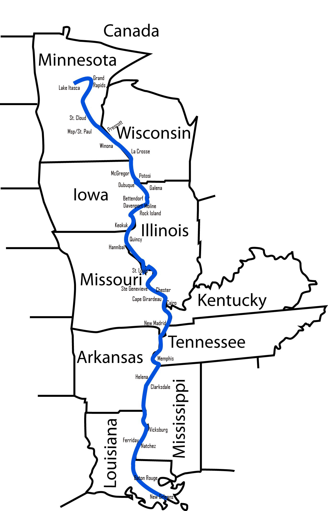
So, how many states does the Mississippi River go through? If we consider the states through which the main channel flows or that it forms a border for, the count is ten:
- Minnesota (Source and initial flow)
- Wisconsin (Forms eastern border)
- Iowa (Forms eastern border)
- Illinois (Forms western border)
- Missouri (Flows through and western border)
- Kentucky (Forms western border)
- Tennessee (Forms western border)
- Arkansas (Forms eastern border)
- Mississippi (Forms western border)
- Louisiana (Flows through and to the Gulf)
This extensive reach underscores the Mississippi River’s status as one of the world’s most significant river systems, a lifeline that has profoundly shaped the history, economy, and culture of the United States. Its journey from a small northern spring to the vast delta is a compelling saga of nature’s power and humanity’s enduring connection to this vital waterway.
LifeOutOfTheBox is a participant in the Amazon Services LLC Associates Program, an affiliate advertising program designed to provide a means for sites to earn advertising fees by advertising and linking to Amazon.com. Amazon, the Amazon logo, AmazonSupply, and the AmazonSupply logo are trademarks of Amazon.com, Inc. or its affiliates. As an Amazon Associate we earn affiliate commissions from qualifying purchases.