
The name Hurricane Katrina is etched into the collective memory of the United States as one of the most devastating natural disasters in history. While the catastrophic events in New Orleans and the breach of its levees dominate the historical narrative, many travelers and history enthusiasts often ask a fundamental question: Did Hurricane Katrina hit Florida? The answer is a definitive yes. In fact, Florida was the site of the storm’s very first landfall, and the impact it left on the state’s natural landmarks and coastal geography was profound.
Understanding the trajectory of Hurricane Katrina is essential for anyone interested in the natural history of the Gulf of Mexico region. Before it became the monster Category 5 storm that loomed over the Mississippi River Delta, it was a developing tropical system that tested the resilience of South Florida. This article explores the timeline of the storm’s passage through the Sunshine State, the specific landmarks affected, and the lasting legacy it left on the Florida landscape.
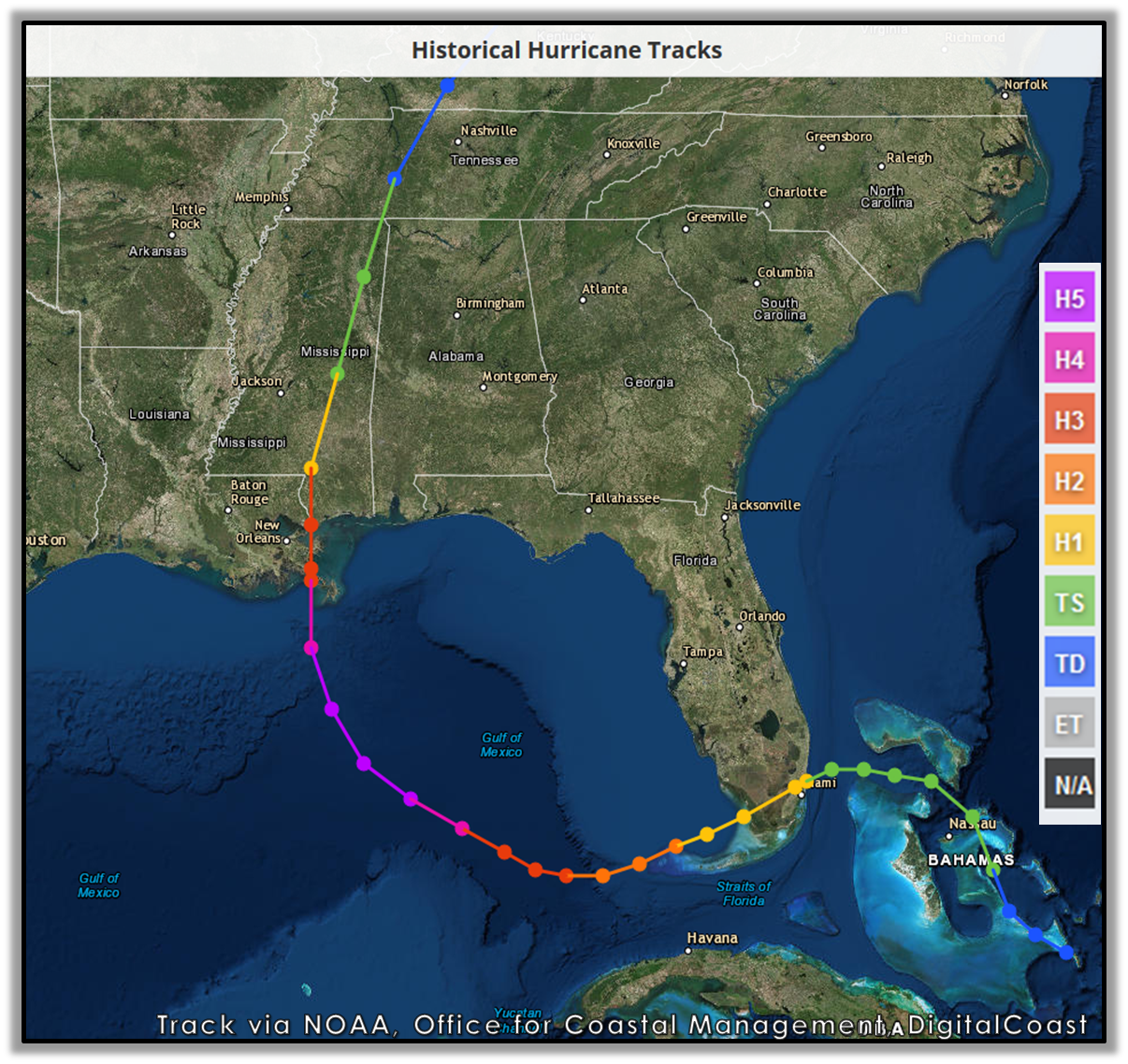
The First Landfall: South Florida’s Encounter
Long before the storm made international headlines for its impact on Louisiana, it was a burgeoning Hurricane Category 1 approaching the Atlantic coast of Florida. On August 25, 2005, the storm made its first official landfall near the border of Miami-Dade County and Broward County. The center of the storm crossed the coastline between Hallandale Beach and Aventura, bringing with it sustained winds of 80 mph and intense rainfall.
Impact on the Miami and Fort Lauderdale Metro Areas
The metropolitan sprawl of Miami and Fort Lauderdale faced the brunt of the storm’s initial energy. While a Category 1 storm is often considered “minor” by seasonal Florida standards, Katrina was deceptively dangerous. It moved slowly across the peninsula, dumping over 15 inches of rain in some areas. This led to significant localized flooding in residential neighborhoods and impacted major transportation arteries used by tourists and locals alike.
Landmarks such as the Monsignor Edward Pace High School suffered notable structural damage, and the iconic Flyover Bridge at the intersection of Interstate 95 and the Dolphin Expressway became a symbol of the storm’s power when a portion of it collapsed under the strain of the winds and rain. For visitors in South Florida at the time, the storm served as a stark reminder of the unpredictability of tropical weather.
The Transit Through the Everglades
After hitting the Atlantic coast, the storm moved southwest across the state. One of the most significant natural landmarks in the world, Everglades National Park, sat directly in its path. As the storm traversed the “River of Grass,” it maintained its hurricane strength, a rare feat for a storm moving over land. The unique topography of the Everglades, which is essentially a shallow, slow-moving sheet of water, provided enough moisture to prevent the storm from weakening significantly.
The impact on the Everglades was primarily ecological. The high winds defoliated vast swaths of mangroves and altered the salinity levels in the Florida Bay. For those who study natural history, the passage of Katrina through Big Cypress National Preserve and the surrounding wetlands provided critical data on how these ecosystems buffer the mainland from storm surges.
The Gulf of Mexico and the Secondary Threat
As Hurricane Katrina exited the Florida peninsula and entered the warm waters of the Gulf of Mexico, it underwent a period of rapid intensification. However, Florida was not yet clear of the danger. The storm’s massive size meant that even as it moved toward the central Gulf Coast, its outer bands continued to lash the Florida Keys and the western coast of the state.
Influence on the Florida Keys
While the eye of the storm was hundreds of miles away, the Florida Keys experienced tropical storm-force winds and significant storm surges. In Key West, the low-lying streets were inundated with seawater, and the famous Dry Tortugas located further west saw even more extreme conditions. The historic Fort Jefferson, a massive masonry coastal fortress, stood as a testament to 19th-century engineering as it weathered the waves generated by the passing hurricane.

The Florida Keys are a chain of islands that are particularly vulnerable to the “dirty side” of a storm—the right-front quadrant where winds and surge are most intense. Even though Katrina was technically a Louisiana and Mississippi event at its peak, the economic impact on the tourism industry in Monroe County was substantial, as coral reefs and fishing grounds were disrupted by the turbulent seas.
The Storm Surge in the Florida Panhandle
Perhaps the most overlooked aspect of Hurricane Katrina’s impact on Florida was what happened in the Florida Panhandle. As the storm grew into a giant in the central Gulf of Mexico, it pushed a massive wall of water toward the northern Gulf Coast. This surge did not stop at the state line.
In Pensacola and Fort Walton Beach, the storm surge reached levels that rivaled previous direct hits. Natural landmarks like the Gulf Islands National Seashore suffered extreme beach erosion. The road to Fort Pickens, a popular destination for history buffs and nature lovers on Santa Rosa Island, was completely washed away in several sections. This was particularly devastating as the area was still recovering from the impact of Hurricane Ivan from the previous year.
Lessons in Resilience and Reconstruction
The legacy of Hurricane Katrina in Florida is one of resilience. While the state was spared the level of tragedy seen in New Orleans, the events of 2005 fundamentally changed how Florida approaches hurricane preparedness and the preservation of its coastal landmarks.
Evolution of Coastal Architecture and Safety
Following the 2005 season, which included not just Katrina but also Hurricane Wilma and Hurricane Rita, Florida significantly updated its building codes. For travelers, this means that the modern resorts in Miami and the vacation rentals in Destin are among the safest structures in the world. The architectural landmarks that define the Florida skyline are now built to withstand the specific pressures that a storm like Katrina produces.
Furthermore, the management of natural sites like Biscayne National Park has evolved. Scientists and park rangers now use the data gathered during Katrina to better understand the role of seagrasses and mangroves in protecting the coastline. For the eco-tourist, visiting these landmarks today offers a chance to see nature’s recovery firsthand. The mangrove forests that were stripped bare in 2005 have largely regrown, providing a lush habitat for manatees, crocodiles, and hundreds of bird species.
The Human Element and Tourism
The impact of Hurricane Katrina also highlighted the interconnectedness of the United States tourism industry. In the aftermath of the storm, Florida became a primary refuge for thousands of displaced residents from Mississippi and Louisiana. Cities like Orlando and Tallahassee opened their doors, and the hospitality sector played a crucial role in the regional recovery effort.
For those planning a trip to Florida, understanding the history of Hurricane Katrina adds a layer of depth to the experience. It is a story of a state that sits at the crossroads of the Atlantic and the Gulf, a peninsula that is both vulnerable to and shaped by the power of the sea. Whether you are exploring the historic streets of Pensacola or taking an airboat tour through the Everglades, the traces of the 2005 hurricane season are part of the landscape’s narrative.

Visiting Florida’s Historic Landmarks Today
Today, the landmarks affected by Katrina have been restored and remain essential stops for any traveler. The Gulf Islands National Seashore continues to offer some of the most pristine white-sand beaches in the United States, and Fort Pickens stands tall, welcoming visitors to explore its coastal batteries and trails. In South Florida, the urban landscape of Aventura and Hallandale Beach shows no outward signs of the storm, yet the enhanced infrastructure below the surface ensures these cities remain vibrant hubs for international tourism.
The question “Did Hurricane Katrina hit Florida?” serves as an entry point into a broader conversation about geography, history, and the enduring spirit of the Gulf Coast. While the storm will always be synonymous with the tragedy in the west, its first chapter was written in the sands and marshes of Florida. Recognizing this history allows visitors to appreciate the delicate balance between the beauty of the Sunshine State and the formidable forces of nature that have helped define its character over the centuries.
From the Bahamas, where the storm first organized, to the shores of the Florida Panhandle, Hurricane Katrina’s journey was a transformative event for the entire region. By exploring the sites that stood in its path, travelers can gain a deeper perspective on the resilience of both the natural world and the communities that call Florida home.
LifeOutOfTheBox is a participant in the Amazon Services LLC Associates Program, an affiliate advertising program designed to provide a means for sites to earn advertising fees by advertising and linking to Amazon.com. Amazon, the Amazon logo, AmazonSupply, and the AmazonSupply logo are trademarks of Amazon.com, Inc. or its affiliates. As an Amazon Associate we earn affiliate commissions from qualifying purchases.