
The name Hurricane Katrina is etched into the collective memory of the United States as one of the most devastating natural disasters in its history. While most historical accounts focus on the catastrophic levee failures and the subsequent flooding of New Orleans in Louisiana, many people forget or are unaware of the storm’s initial chapter. To answer the question “Did Katrina hit Florida?”—the answer is a definitive yes. Long before it became the monstrous Category 5 storm in the central Gulf of Mexico, it made its first landfall as a Category 1 hurricane in South Florida.
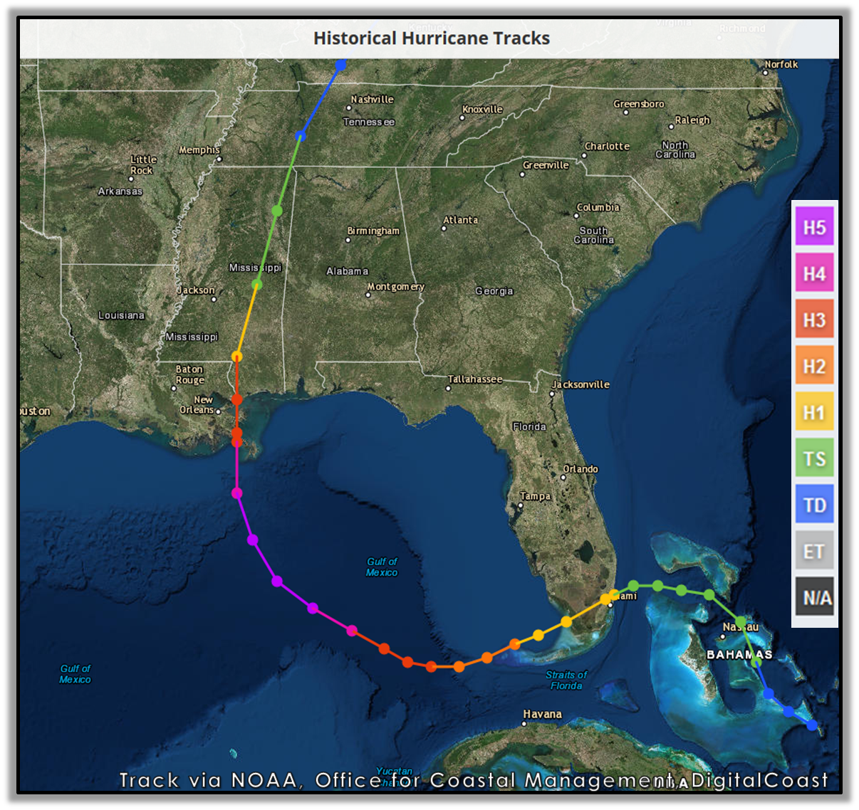
Understanding the history of this storm requires looking at Florida not just as a bystander to the tragedy in the Gulf Coast, but as a primary target that faced significant wind damage, flooding, and ecological disruption. From the urban landmarks of Miami to the fragile ecosystems of Everglades National Park, the footprint of the storm was substantial and served as a precursor to the larger tragedy that would follow.
The First Landfall: South Florida’s Encounter with a Rising Giant
In late August 2005, Hurricane Katrina formed over the Bahamas. As it moved toward the Florida coast, the National Hurricane Center monitored its rapid intensification. On the evening of August 25, the storm made landfall near the border of Miami-Dade County and Broward County. Specifically, the eye of the storm crossed the coastline between Hallandale Beach and Aventura.
Impact on Urban Infrastructure and Landmarks
When the storm hit the South Florida coast, it packed sustained winds of approximately 80 miles per hour. While these figures pale in comparison to the 175-mph winds the storm would later generate, they were more than enough to cause widespread power outages and structural damage. In Miami, the storm’s passage was marked by the sight of fallen trees, damaged signage, and flooded streets.
One of the most notable architectural impacts occurred at the Miami International Airport, which had to suspend operations, leaving thousands of travelers stranded. The storm also tested the resilience of the Florida Department of Transportation infrastructure, as several overpasses and local roads in Fort Lauderdale suffered from debris blockage and minor structural stressors. For the residents of Homestead and Kendall, the storm was a frightening reminder of Hurricane Andrew, though Katrina was significantly less intense at this stage of its life cycle.
The Flooding of Suburban Miami
Beyond the wind, the primary threat to the landmarks and residential areas of South Florida was the rain. Hurricane Katrina dropped over 15 inches of rain in some parts of Miami-Dade County. This led to the flooding of several local landmarks, including shopping districts and historic neighborhoods. The storm surge, while modest compared to what would hit Mississippi, still pushed water into the coastal canals, threatening the foundations of luxury villas and apartment complexes that line the Intracoastal Waterway.
Natural Landmarks Under Pressure: The Everglades and the Keys
As Hurricane Katrina traversed the Florida peninsula, it moved directly over the state’s most famous natural landmark: the Everglades. The storm entered the Gulf of Mexico just north of Cape Sable, leaving a trail of ecological transformation in its wake.
Ecological Shifts in Everglades National Park
The Everglades National Park is a delicate balance of sawgrass prairies and mangrove forests. The high winds and heavy rains of the storm physically altered the landscape. Thousands of acres of mangroves were defoliated or uprooted. These mangroves serve as a critical natural defense for the Florida coastline, and their destruction left the area more vulnerable to future storms like Hurricane Wilma, which hit later that same year.
In the Flamingo outpost, located at the southernmost tip of the park, the storm surge flooded historic visitor centers and lodges. The damage was so severe that many of the facilities remained closed or under-resourced for years, fundamentally changing the tourism experience in the park. Big Cypress National Preserve also saw significant flooding, which altered the water levels of the wetlands and impacted the habitat of the Florida panther.
Impact on the Florida Keys and Coastal Lighthouses
While the eye of the storm passed to the north, the Florida Keys were caught in the storm’s “dirty side,” where the strongest winds and highest surges often occur. In Monroe County, islands like Key Largo and Islamorada experienced tropical-storm-force winds that damaged docks and local marinas.

Historic maritime landmarks were also at risk. The Fowey Rocks Lighthouse, located within the boundaries of Biscayne National Park, stood firm against the waves, but its structure was a testament to the power of the Atlantic Ocean. Further south, the Cape Florida Lighthouse in Bill Baggs Cape Florida State Park witnessed significant beach erosion, a common fate for the famous places along the Florida coast during major weather events.
The Hidden Impact: The Florida Panhandle and the Second Surge
Many people believe that once Hurricane Katrina left the Florida peninsula and headed toward the Gulf of Mexico, the state’s troubles were over. However, as the storm expanded into a massive Category 5 hurricane, its outer bands and massive wind field continued to lash the Florida Panhandle.
The Forgotten Surge in Pensacola
While the eye made landfall near Waveland, Mississippi, the counter-clockwise rotation of the storm pushed a massive surge of water into Pensacola. This “secondary” impact was devastating for the landmarks of Northwest Florida. The storm surge in Walton County and Bay County caused significant beach erosion and damaged the coastal architecture of popular tourist destinations like Destin.
Historic piers and coastal roads were washed away or severely undermined. In Pensacola Beach, residents who were still recovering from Hurricane Ivan the previous year found themselves facing another round of flooding. The sheer size of Hurricane Katrina meant that its effects were felt as far east as St. Marks, where the rising waters of the Gulf of Mexico threatened the historic St. Marks Lighthouse.
Resilience and Reconstruction: Lessons in Architectural History
The impact of the storm on Florida served as a critical case study for architectural resilience and disaster management. In the aftermath, the state’s approach to preserving its landmarks and building new ones underwent a transformation.
Strengthening Iconic Structures
The Seven Mile Bridge and the Overseas Highway are perhaps the most vital pieces of infrastructure in the Florida Keys. During the storm, these landmarks remained largely intact, but the event highlighted the necessity of constant maintenance and reinforcement against salt-water intrusion and high-velocity winds. The Florida Department of Transportation accelerated programs to ensure that these lifelines could withstand even more powerful hurricanes in the future.
Furthermore, the damage to the Everglades led to a renewed focus on the Comprehensive Everglades Restoration Plan. Scientists and historians realized that the health of natural landmarks is directly tied to the state’s ability to survive hurricanes. Restoring natural water flows and protecting mangrove forests became seen not just as an environmental goal, but as a historical and architectural necessity for protecting the Florida coastline.
Comparing Katrina to Other Florida Tempests
To fully appreciate Hurricane Katrina’s place in Florida history, it must be compared to other legendary storms. While Hurricane Andrew in 1992 remains the benchmark for wind destruction in South Florida, and Hurricane Michael later devastated the Panhandle, Katrina represents the complexity of a multi-landfall event.
It was a storm that hit twice: once as an emerging threat in the east and again as a massive, distant engine of surge in the west. This dual impact makes it a unique chapter in the history of Florida’s landmarks. The lessons learned between the first landfall in Aventura and the final devastation in the Gulf Coast helped the Federal Emergency Management Agency and state authorities refine their response strategies for future catastrophes.

Conclusion: The Dual Identity of Hurricane Katrina in Florida History
When we ask “Did Katrina hit Florida?”, we are looking at a story of two different states. One was the South Florida of Miami-Dade and Broward, which took the initial blow and faced a “standard” hurricane experience. The other was the Florida Panhandle, which experienced the fringe effects of a historic monster.
The landmarks of Florida—from the neon lights of Miami Beach to the quiet majesty of the Dry Tortugas National Park—are more than just tourist attractions; they are the physical records of the state’s endurance. Hurricane Katrina remains a vital part of that record. It is a reminder that even when a storm’s most famous tragedies occur elsewhere, the “Sunshine State” often stands at the front lines, bearing the first marks of nature’s most powerful forces. The preservation of Florida’s history and its famous places is a constant battle against the elements, and the legacy of the 2005 storm season continues to shape how those landmarks are protected and celebrated today.
LifeOutOfTheBox is a participant in the Amazon Services LLC Associates Program, an affiliate advertising program designed to provide a means for sites to earn advertising fees by advertising and linking to Amazon.com. Amazon, the Amazon logo, AmazonSupply, and the AmazonSupply logo are trademarks of Amazon.com, Inc. or its affiliates. As an Amazon Associate we earn affiliate commissions from qualifying purchases.